#post-glacial rebound
Text

In addition to 'squishy', after reviewing my submitted intraplate ground motion data, the National Geodetic Survey has politely asked me to stop using the word 'supple' so often when describing Midwestern states.
Minnesota [Explained]
Transcript
[Hairy standing in front of Ponytail and Cueball, who are sitting behind a desk]
Hairy: Does anyone have any other concerns?
Cueball: I'm concerned that Minnesota is getting shorter.
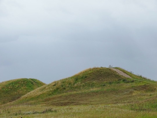
[A map of Minnesota beside Cueball, with arrows pointing from the northern and southern borders towards the middle]
Cueball: Because of post-glacial crust rebound, the northern border is moving toward the southern border. It's less than an inch a decade, but I still don't like it.
Cueball: Minnesota shouldn't be squishy.
[Hairy again standing in front of Ponytail and Cueball at the desk. Ponytail is looking at Cueball, whose finger is now raised in the air, gesturing]
Hairy: Okay. Does anyone have any concerns related to the topic of this meeting?
Cueball: All meetings should be about Minnesota until we resolve this.
540 notes
·
View notes
Text

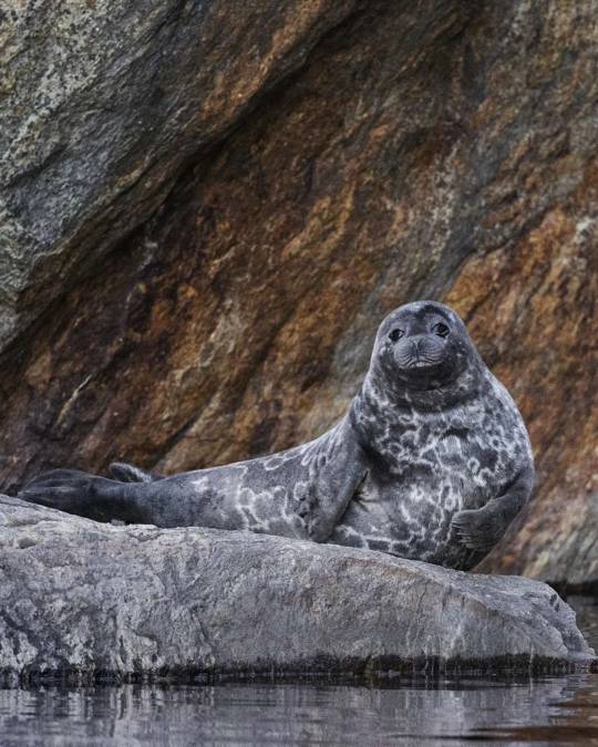
Special interest infodump time [facilitated by an art challenge I'm taking part in over on my instagram] this episode: The Saimaa Ringed Seal!
The Saimaa Ringed seal is a subspecies of ringed seal endemic to Lake Saimaa in Finland. They have evolved separately from other species of glacial ringed seals for nearly 10,000 years after being separated in the forming of Lake Saimaa during post glacial rebound at the end of the last ice age. That prolonged and continued period of isolation has caused them to have broken off into their own, incredibly rare geographically specific and small numbered morphology [other animals to exhibit this include the Devil's Hole Pupfish of death valley]. Due to this nature, while they face endangerment due to the same reasons as many other seals [bycatch mortality, hunting, pollution etc] they also face it purely from a rarity angle, isolated species populations in the sub-1,000s are always going to be incredibly delicate by virture of not having the "padding" of large count numbers on their side.
That said! Conservationists in Finland work closely with the government to do their best to make sure these adorable freshwater seals have the best shot they can at sticking around, and Metsähallitus was very excited to report that this year was a record-high year for Saimaa Ringed Seal pups! Noting that their annual census for 2023 counted 100 pups [the highest count they have ever had! And a HUGE number considering the overall population of the species is estimated around 410 total seals] The organization thinks it's possible the continued increase may be caused by recent net fishing bans in certain parts of the lake allowing more seals to survive to reproductive age, and hope the bans can continue to expand to further parts of the lake as well to increase this encouraging and exciting momentum.
Onnea teille pikku hyljit!! 🦭🩵🇫🇮
#embroidery#saimaa ringed seal#fiber art#fibre art#animal art#endangered species#conservation#marine biology#seals#traditional art#beadwork
533 notes
·
View notes
Text
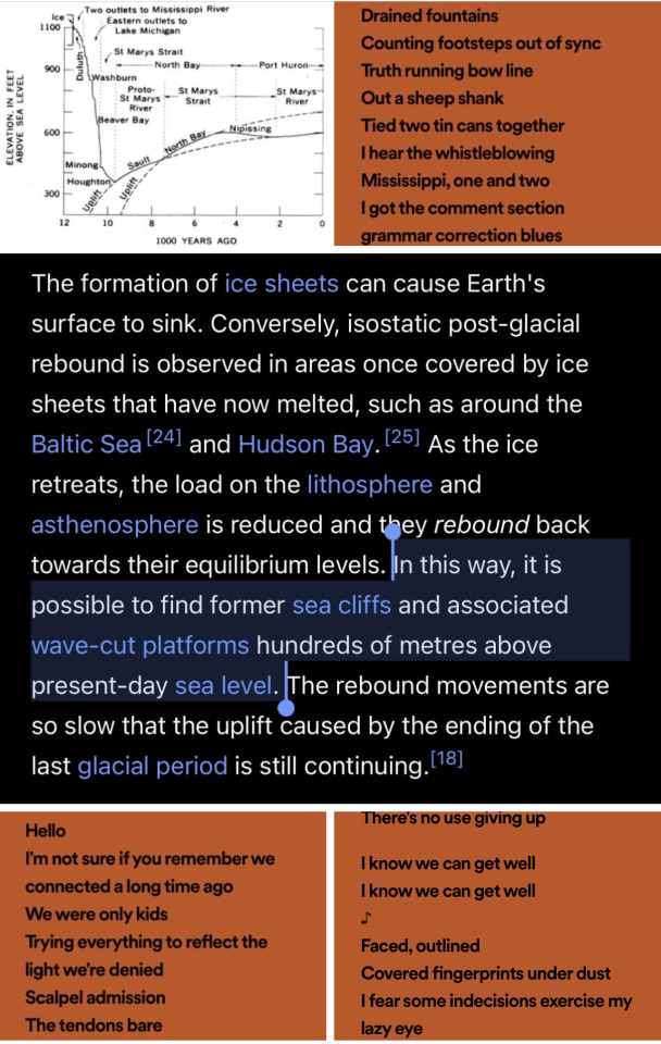
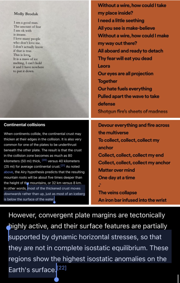


lyrics from past lives by ls dunes / screenshots from wikipedia articles on isostasy and post glacial rebound / poem by molly brodak
90 notes
·
View notes
Text
TIL about post-glacial rebound, and how southeast England is tilting into the ocean at a rate of 5cm a century...
#that's not all i learned#i also learned about the paper released earlier this year about the gulf stream#that predicted it could shut down as early as 2025#and while i agree with the criticisms of the paper and think a prediction of 2100 is more accurate#i am well aware of how screwed we are#i'm currently working for a non profit that provides a voice for charities with the gov#and climate change is one of my areas#and hoboy.#jesus h christ#tmi
13 notes
·
View notes
Text

The red-brown rapakivi granite bedrock on Ulko-Tammio Island off southeastern Finland has been polished by ice age glaciers. With the weight of the glacial ice removed, the landscape is experiencing post-glacial rebound.
2 notes
·
View notes
Text
Concepts that I'm constantly baffled my American friends aren't very familiar with despite the fact that they have no reason to be, because they're so obviously important to me:
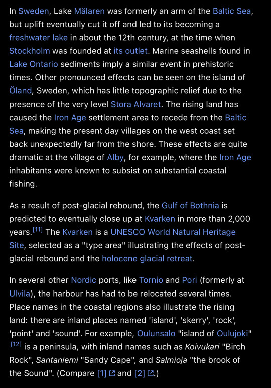
Landhöjningen = the land rising (technically "tectonic uplift", to be specific, post-glacial rebound in this case ) All of Scandinavia was under a thick layer of ice during the last ice age, and the land is still rising significant amounts, to the point where archeology of port cities are now inland.
Trädgränsen = the tree line, when you get to a high enough elevation (exposure and temperature) or latitude (temperature) that nothing that qualifies as trees grow.
5 notes
·
View notes
Text
NASA InSight study finds Mars is spinning faster
Scientists have made the most precise measurements ever of Mars's rotation, for the first time detecting how the planet wobbles due to the "sloshing" of its molten metal core. The findings, detailed in a recent Nature paper, rely on data from NASA's InSight Mars lander, which operated for four years before running out of power during its extended mission in December 2022.
To track the planet's spin rate, the study's authors relied on one of InSight's instruments: a radio transponder and antennas collectively called the Rotation and Interior Structure Experiment, or RISE. They found the planet's rotation is accelerating by about 4 milliarcseconds per year—corresponding to a shortening of the length of the Martian day by a fraction of a millisecond per year.
It's a subtle acceleration, and scientists aren't entirely sure of the cause. But they have a few ideas, including ice accumulating on the polar caps or post-glacial rebound, where landmasses rise after being buried by ice. The shift in a planet's mass can cause it to accelerate a bit like an ice skater spinning with their arms stretched out, then pulling their arms in.
"It's really cool to be able to get this latest measurement—and so precisely," said InSight's principal investigator, Bruce Banerdt of NASA's Jet Propulsion Laboratory in Southern California. "I've been involved in efforts to get a geophysical station like InSight onto Mars for a long time, and results like this make all those decades of work worth it."
How RISE works
RISE is part of a long tradition of Mars landers using radio waves for science, including the twin Viking landers in the 1970s and the Pathfinder lander in the late '90s. But none of those missions had the advantage of InSight's advanced radio technology and upgrades to the antennas within NASA's Deep Space Network on Earth. Together, these enhancements provided data about five times more accurate than what was available for the Viking landers.
In the case of InSight, scientists would beam a radio signal to the lander using the Deep Space Network. RISE would then reflect the signal back. When scientists received the reflected signal, they would look for tiny changes in frequency caused by the Doppler shift (the same effect that causes an ambulance siren to change pitch as it gets closer and farther away). Measuring the shift enabled researchers to determine how fast the planet rotates.
"What we're looking for are variations that are just a few tens of centimeters over the course of a Martian year," said the paper's lead author and RISE's principal investigator, Sebastien Le Maistre at the Royal Observatory of Belgium. "It takes a very long time and a lot of data to accumulate before we can even see these variations."
The paper examined data from InSight's first 900 Martian days—enough time to look for such variations. Scientists had their work cut out for them to eliminate sources of noise: Water slows radio signals, so moisture in the Earth's atmosphere can distort the signal coming back from Mars. So can the solar wind, the electrons and protons flung into deep space from the sun.
"It's a historic experiment," said Le Maistre. "We have spent a lot of time and energy preparing for the experiment and anticipating these discoveries. But despite this, we were still surprised along the way—and it's not over, since RISE still has a lot to reveal about Mars."
Martian core measurements
RISE data was also used by the study authors to measure Mars's wobble—called its nutation—due to sloshing in its liquid core. The measurement allows scientists to determine the size of the core: Based on RISE data, the core has a radius of roughly 1,140 miles (1,835 kilometers).
The authors then compared that figure with two previous measurements of the core derived the from spacecraft's seismometer. Specifically, they looked at how seismic waves traveled through the planet's interior—whether they reflected off the core or passed through it unimpeded.
Taking all three measurements into account, they estimate the core's radius to be between 1,112 and 1,150 miles (1,790 and 1,850 kilometers). Mars as a whole has a radius of 2,106 miles (3,390 kilometers)—about half the size of Earth's.
Measuring Mars's wobble also provided details about the shape of the core.
"RISE's data indicate the core's shape cannot be explained by its rotation alone," said the paper's second author, Attilio Rivoldini of the Royal Observatory of Belgium. "That shape requires regions of slightly higher or lower density buried deep within the mantle."
While scientists will be mining InSight data for years to come, this study marks the final chapter for Banerdt's role as the mission's principal investigator. After 46 years with JPL, he retired on Aug. 1.
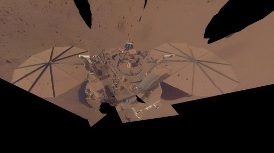
TOP IMAGE....NASA’s InSight lander captured this selfie on April 24, 2022, the 1,211th Martian day, or sol, of the mission. Dust on its solar panels caused the lander to lose power in December of that year, but data recorded by InSight’s instruments is still leading to new science. Credit: NASA/JPL-Caltech
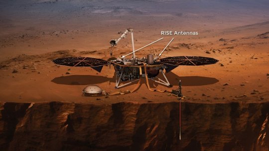
LOWER IMAGE....This annotated artist’s concept of NASA’s InSight lander on Mars points out the antennas on the spacecraft’s deck. Along with a radio transponder in the lander, these antennas made up an instrument called the Rotation and Interior Structure Experiment, or RISE. Credit: NASA/JPL-Caltech
2 notes
·
View notes
Video

flickr
Sisimiut from The Sea by Tony
Via Flickr:
Sisimiut literally means "the residents at the foxholes" Sisimiut has been a settlement site for around 4,500 years, with the people of the Saqqaq culture arriving from Arctic Canada during the first wave of immigration, occupying numerous sites on the coast of western Greenland. At that time, the shoreline was up to several dozen meters above the present line, gradually decreasing in time due to post-glacial rebound.
#Sisimiut#ambassador#ambience#america#atlantic#clouds#copyrite ©2022 Tony Sherratt#cruise#cruise ship#greenland#houses#mountains#sky#town#weather#2022 07 01 065924#flickr
16 notes
·
View notes
Text

GPS in Surveying: Mapping the World with High Precision
In the realm of modern surveying and cartography, the Global Positioning System (GPS) has emerged as a game-changing technology, revolutionizing the way we map and measure the world around us. From land surveying to geodesy, construction to urban planning, and everything in between, GPS has become an indispensable tool for professionals seeking to achieve the highest levels of accuracy and precision in their work.
The Evolution of Surveying: From Theodolites to GPS
Surveying is an ancient practice that dates back thousands of years. Traditionally, surveyors relied on instruments like theodolites and transit levels, combined with painstaking measurements and trigonometric calculations, to determine the positions of points on the Earth's surface. While this approach served well for many centuries, it had its limitations, especially when it came to covering large areas or dealing with challenging terrains.
The advent of GPS technology transformed the field of surveying. In the 1970s and 1980s, the United States Department of Defense established the Navstar GPS program, which eventually led to the development of a constellation of satellites dedicated to providing precise positioning and timing information. These satellites broadcast signals that could be received by GPS receivers on the ground. Surveyors quickly recognized the potential of this system to revolutionize their work.
How GPS Surveying Works
At its core, GPS surveying relies on a simple principle: triangulation. By receiving signals from multiple satellites in space, a GPS receiver can determine its precise location on Earth by calculating the intersecting points of these signals. However, the accuracy and precision of GPS surveying depend on several factors:
Satellite Geometry: The arrangement of satellites in the sky can affect the quality of positioning. A wider spread of satellites provides more accurate results.
Atmospheric Effects: The Earth's atmosphere can introduce delays in GPS signals, affecting accuracy. Differential GPS (DGPS) techniques are used to correct for these errors.
Multipath Interference: Signals can bounce off surfaces like buildings or terrain before reaching the receiver, leading to inaccuracies.
Receiver Quality: The quality and sophistication of the GPS receiver play a significant role in determining accuracy.
Post-Processing: Surveyors often use post-processing software to further refine their GPS data and achieve higher levels of accuracy.
Precision Surveying Applications
GPS technology has opened up a wide range of applications in the field of precision surveying:
Land Surveying
Land surveyors use GPS to accurately measure and map the boundaries of land parcels, determine property lines, and create topographic maps. GPS allows for efficient and precise land surveying, reducing the likelihood of boundary disputes and errors.
Construction
Construction professionals use GPS to guide heavy machinery and equipment with high precision. This ensures that structures are built according to design specifications and that they are properly aligned with the surrounding landscape.
Geodesy
Geodesy is the science of measuring the Earth's shape, orientation, and gravitational field. GPS has revolutionized geodesy by providing an efficient way to measure and monitor subtle changes in the Earth's surface, such as tectonic movements and post-glacial rebound.
Environmental Monitoring
Environmental scientists use GPS to track the movement of glaciers, study the effects of sea-level rise, and monitor changes in ecosystems. GPS technology provides valuable data for understanding the impacts of climate change on our planet.
Mining and Resource Management
In the mining industry, GPS is used for surveying, mapping, and monitoring stockpiles of resources. It helps optimize resource extraction while minimizing environmental impact.
Infrastructure Development
Urban planners and civil engineers rely on GPS to plan and develop infrastructure projects like roads, bridges, and utilities. GPS technology ensures that these projects are executed with precision, reducing construction errors and maintenance costs.
Archaeology
Archaeologists use GPS to record the locations of archaeological sites and artifacts accurately. This aids in preserving cultural heritage and allows for more precise excavations.
Challenges and Considerations
While GPS technology has brought unprecedented accuracy and efficiency to surveying, it is not without challenges:
Satellite Coverage: In remote or densely forested areas, satellite coverage can be limited, affecting the accuracy of GPS measurements. In such cases, alternative solutions like ground-based reference stations may be used.
Signal Interference: Interference from buildings, trees, or other obstructions can disrupt GPS signals. Careful planning and site selection are essential to mitigate this issue.
Cost: High-precision GPS equipment can be expensive. However, the cost is often justified by the time and resources saved in surveying projects.
Data Processing: Processing GPS data to achieve high precision can be complex and time-consuming, requiring specialized software and expertise.
The Future of GPS Surveying
As technology continues to advance, the future of GPS surveying holds exciting possibilities. Some trends to watch for include:
Multi-Constellation Systems: The integration of multiple satellite constellations (e.g., GPS, GLONASS, Galileo, and BeiDou) will provide more robust and accurate positioning data.
Real-Time Kinematic (RTK) GPS: RTK GPS techniques, which allow for centimeter-level accuracy in real-time, are becoming more accessible and affordable.
Unmanned Aerial Vehicles (UAVs): Drones equipped with GPS technology are increasingly used for aerial surveys and mapping, offering new perspectives and efficiencies.
Artificial Intelligence (AI): AI algorithms are being employed to enhance the processing and interpretation of GPS data, improving accuracy and speed.
Conclusion
GPS technology has ushered in a new era of precision surveying, enabling professionals to map the world with unprecedented accuracy and efficiency. From land boundaries to construction projects, environmental monitoring to infrastructure development, GPS has become an essential tool for those seeking to understand and shape our world.
As technology continues to advance, the applications of GPS surveying will expand, and its accuracy will improve further. The role of GPS in shaping our understanding of the Earth's surface and supporting critical decision-making processes across various industries is only set to grow. With GPS as their guiding star, surveyors will continue to map and measure our world with unparalleled precision.
0 notes
Link
In December 2022, NASA lost contact with its Interior Exploration using Seismic Investigations, Geodesy and Heat Transport (InSight) Mars lander, which had been operating on the Martian surface for just over four years. In the time since InSight’s mission was declared over, scientists have continued to analyze the incredible data the lander collected and have made some exciting discoveries. One team of scientists, led by Sebastien Le Maistre of the Royal Observatory of Belgium, recently published research that utilized InSight’s Rotation and Interior Structure Experiment (RISE) instrument to show that Mars’ rotational speed is increasing. The measurements are the most precise measurements of Mars’ rotation ever taken, and even show how the planet wobbles due to the movement of the planet’s molten metal core. As mentioned, Le Maistre et al. used InSight’s RISE instrument, which is a collection of radio transponders and antennas, to make their measurements. They ultimately found that Mars’ rotational speed is accelerating by approximately four milliarcseconds per year squared. The increase in rotational speed corresponds to the length of the Martian day decreased by a fraction of a millisecond per year. Artist’s depiction of InSight on the surface of Mars. Note the RISE antennas on the lander. (Credit: NASA/JPL-Caltech) “It’s really cool to be able to get this latest measurement — and so precisely. I’ve been involved in efforts to get a geophysical station like InSight onto Mars for a long time, and results like this make all those decades of work worth it,” said Bruce Banerdt, InSight’s principal investigator of NASA’s Jet Propulsion Laboratory. See AlsoInSight UpdatesSpace Science CoverageL2 Future SpacecraftClick here to Join L2 While the acceleration is quite small, scientists are still unsure of its cause. One scenario that scientists believe could’ve caused the acceleration is that ice accumulated on the polar ice caps or post-glacial rebound (the rising of landmasses after being buried under ice). By conservation of angular momentum, a significant shift in the mass of a planetary body leads to an acceleration in rotation — similar to how a spinning ice skater speeds up after pulling their arms inward. Using radio waves to learn more about Mars’ characteristics is not unique to InSight. Previous Mars landers, such as the two Viking landers and Pathfinder, employed the use of radio waves to learn more about Mars’ interior and characteristics. However, InSight’s access to advanced radio technology and upgrades to NASA’s Deep Space Network (DSN) allowed InSight to provide scientists with data that was five times more accurate than that from Pathfinder and the Vikings. So, how did Le Maistre et al. measure the rotational speed of Mars? When InSight was still operational, the scientists used the DSN to beam a radio signal at InSight, which operated in the Elysium Planitia region of Mars. When InSight received the signal, RISE reflected the signal back to Earth. When the DSN received the reflected signal, scientists would take a look at the data and look for small changes in the signal’s frequency caused by the Doppler shift. Measuring the shift in frequency allowed the scientists to determine the rotational speed of Mars. “What we’re looking for are variations that are just a few tens of centimeters over the course of a Martian year. It takes a very long time and a lot of data to accumulate before we can even see these variations,” said Le Maistre. Given the extremely small variations in the signal frequencies, Le Maistre et al. had to look at frequency data from InSight’s first 900 Martian days, or sols, to notice the variations. Furthermore, the slight variations in frequency meant that eliminating sources of noise, such as moisture from Earth’s atmosphere and solar wind, from the data would be a challenge. “It’s a historic experiment. We have spent a lot of time and energy preparing for the experiment and anticipating these discoveries. But despite this, we were still surprised along the way — and it’s not over, since RISE still has a lot to reveal about Mars,” Le Maistre said. As mentioned, the RISE data used by Le Maistre et al. was so precise that it picked up Mars’ nutation — the planet’s wobbling motion caused by the sloshing of Mars’ molten metal core. The RISE data allowed the team to measure the size of the core, which they found to have a radius of approximately 1,835 kilometers. Additionally, the nutation gave scientists further insight into the shape and characteristics of the core. Mars is spinning faster! Before it retired last December, @NASAInSight sent back radio science data that’s providing new details about how fast Mars rotates and how much it wobbles. See what the latest findings mean: https://t.co/G47N5oY89s — NASA Mars (@NASAMars) August 7, 2023 But Le Maistre et al. didn’t stop there. They continued with their research of the core and compared their measurement of the core’s size to other measurements derived from data collected by InSight’s seismometer. Specifically, the team looked at whether seismic waves within Mars reflected off of the core or if they traveled through the core uninterrupted, which allowed them to estimate the radius of the core. All three measurements showed that the core was anywhere between 1,790 and 1,850 kilometers. “RISE’s data indicate the core’s shape cannot be explained by its rotation alone. That shape requires regions of slightly higher or lower density buried deep within the mantle,” said co-author Attilio Rivoldini of the Royal Observatory of Belgium. Le Maistre et al.’s results are just the beginning. The team will continue to analyze the RISE data in hopes of learning more about Mars’ rotation, core, and other planetary characteristics. Although InSight’s mission may be over, the incredible data it gathered during its four-year mission will continue to allow scientists to make groundbreaking discoveries in planetary science for the months, years, and decades to come. Le Maistre et al.’s data and results were published in the journal Nature in June 2023. (Lead image: InSight takes a selfie on April 24, 2022, the 1,211th sol of the mission. Credit: NASA/JPL-Caltech) The post Using data from InSight, scientists discover that Mars is rotating faster appeared first on NASASpaceFlight.com.
0 notes
Link
Excerpt from this article by Nexus Media and published by EcoWatch:
Scientists know that sea levels have risen more in some places during the past century than in others. They've gone up faster along the Mid-Atlantic States, particularly near Cape Hatteras and the Chesapeake Bay, compared to north along the Gulf of Maine and south along the South Atlantic Bight. But why?
"Sea-level rise affects us all," said Chris Piecuch, assistant scientist at the Woods Hole Oceanographic Institution and lead author of a new study recently published in the journal Nature that explains the reasons for sea-level rise variations on the East Coast. "Those of us who live on the coast are feeling, and will continue, to feel more acutely its effects. But even those who don't live on the coast will feel the effects. Going into the future, over the coming centuries, multiple meters of global sea-level rise are possible. And even if the nature of storms doesn't change in the future, the higher 'baseline' of rising seas will make the impacts of coastal storms worse. Sea-level rise will come, making the bad worse."
Piecuch and his colleagues attribute the "unequal" sea-level rise in the East to a phenomenon known as "post-glacial rebound."
Thousands of years ago, large ice sheets covered large parts of northern North America, including large swaths of Canada and the northeastern U.S. As a consequence—because the ice sheets were so massive and heavy—they weighed down Earth's crust, causing it to sink directly beneath the ice sheet. "As a result, places that were around the edges or periphery of that ice sheet were actually levered up," Piecuch explained. "It's an imperfect analogy, but you can perhaps think of a see-saw. When you sit on one end of a seesaw, it goes down, whereas the other end of the seesaw goes up. Again, this was the picture thousands of years ago."
In the intervening time, the ice sheets melted, reducing the weight. As a result, the areas formerly sunken down under that massive weight could relax and rise up, whereas those regions around the edges that were formerly levered or bulged up sank, he said. "The seesaw is again helpful here," he said. "If you imagine stepping off the seesaw now, the end you'd been sitting on can rise back up, whereas the other end now sinks down."
Even though the ice sheets had disappeared by 7,000 years ago, the see-sawing of post-glacial rebound continues to this day, he said. "Because the Earth responds so gradually—and is, in a sense, still feeling the last ice age—that 'reverse' see-sawing is still ongoing, with land moving up in some places and down in others," he said. "And it's that spatially variable land motion that gives the effect of different rates of sea-level rise at different places on the East Coast."
5 notes
·
View notes
Link
The research team found that post-glacial rebound accounted for most of the variation in sea level rise along the East Coast. But, importantly, when that factor was stripped away, the researchers found that "sea level trends increased steadily from Maine all the way down to Florida," Piecuch said.
"The cause for that could involve more recent melting of glaciers and ice sheets, groundwater extraction and damming over the last century", Piecuch says. "Those effects move ice and water mass around at Earth's surface, and can impact the planet's crust, gravity field and sea level."
"Post-glacial rebound is definitely the most important process causing spatial differences in sea level rise on the U.S. East Coast over the last century. And since that process plays out over millennia, we're confident projecting its influence centuries into the future," Piecuch explains. "But regarding the mass redistribution piece of the puzzle, we're less certain how that's going to evolve into the future, which makes it much more difficult to predict sea level rise and its impact on coastal communities."
4 notes
·
View notes
Photo
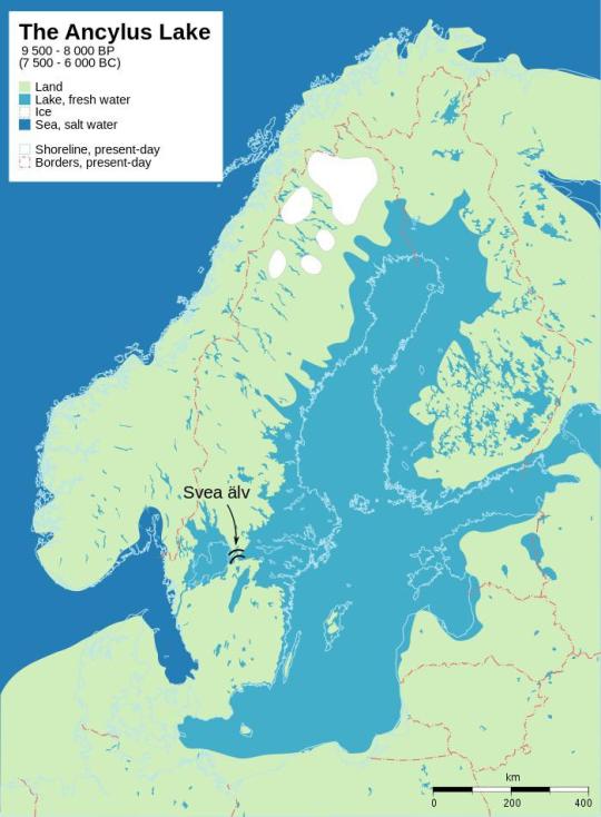
The Ancylus Lake, Baltic Sea, 7500-6000 B.C.
Post-glacial rebound and shore displacement of the Baltic Sea.
242 notes
·
View notes
Photo
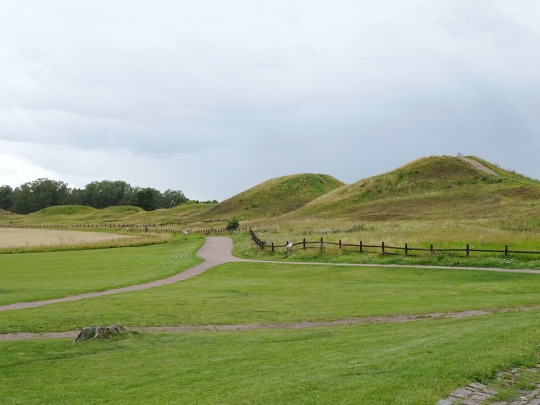


Old Uppsala Archaeological Area, Sweden (No. 1)
It is a testimony to the sanctity of the location in the mindset of followers of medieval Norse religion that Gamla Uppsala was the last stronghold of pre-Christian, Norse Germanic kingship. During the 1070s and 1080 there appears to have been a renaissance of Norse religion with the magnificent Temple at Uppsala described in a contested account through an eye-witness by Adam of Bremen. Adam of Bremen relates of the Uppsala of the 1070s and describes it as a pagan cult centre with the enormous Temple at Uppsala containing wooden statues of Odin, Thor and Freyr.
Sometime in the 1080s the Christian king Ingi was exiled for refusing to perform the sacrifices. Instead Blot-Sweyn was elected, but he was killed by Ingi who could then reclaim his throne.
Its great importance in Swedish tradition led to the location of Sweden's first Archbishopric in Gamla Uppsala in 1164. In practice, however, it had lost its strategic importance when it gradually lost ready access to navigable waters as the land rose owing to the constant post-glacial rebound.
Source: Wikipedia
#Old Uppsala Archaeological Area#Gamla Uppsala#Swedish history#landscape#countryside#Uppsala#Uppland#Gamla Uppsala högar#nature#flora#free admission#Old Uppsala Ancient Monument Area#Gamla Uppsala ancient site#King's Mounds#Nordic Bronze Age#Iron Age#Viking Age#Kungshögarna#wildflower#blooming#fence#Sweden#Sverige#tourist attraction#summer 2020#travel#landmark#vacation#hills#Scandinavia
36 notes
·
View notes
Text
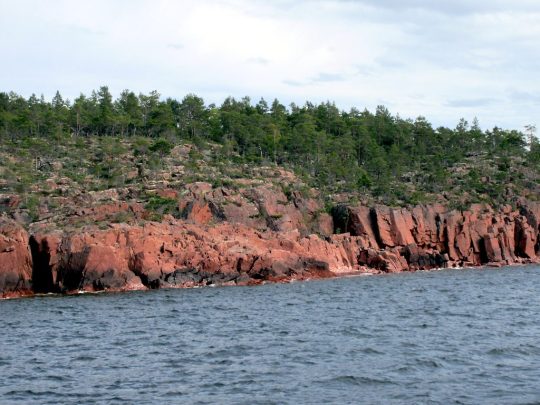
The red cliffs of the Sub-Cambrian peneplain has been exposed by post-glacial rebound along the shore of South Ulvön Island in the Gulf of Bothnia, Sweden.
2 notes
·
View notes
Note
i read your review of naomi's episode and i saw that you mentioned many times that naomi belonged to emily and vice versa. i don't know how to write this so you don't think that i'm judging you because i really just want to know your opinion: don't you think it's a bit weird or problematic to say that someone's yours or that you belong to someone? even in a gay relationship with no age gap like naomi and emily's, some people might have a problem with it
I think I actually only say "belong" once in that post. I think I talk more about how Emily knows that Naomi likes her and so she's willing to move at a glacial speed and rebound from Naomi's rebuffs because she knows eventually it will work out. But I do see your point.
I don't think it's problematic, at least, not in the context of the relationship the show gives us. I think Skins wants us to view Naomi and Emily as soulmates, two people who belong together for the rest of their lives despite any challenges they face. And so I think it wants us to believe that they do "belong" to one another in some sort of metaphysical sense. It's not a property thing, like "Emily owns Naomi and gets to decide what happens to her". Their relationship is pretty well balanced in terms of power dynamics, and both of them make decisions for themselves. There's no dynamic of control. I think it's more "belonging" as "acceptance as a part of something". Naomi is a part of Emily, and Emily is a part of Naomi. They "belong" to each other in that they're an essential part of one another. They "belong" to one another in that they're loyal to their relationship and aren't interested in being with other people. And they provide belonging to one another- at their best, Naomi and Emily love each other fully, without judgement. They both struggle to feel that sense of belonging among other people (for example, Naomi feels that she doesn't belong in her house, where her mum has a commune of strangers, and Emily doesn't feel like her family accepts her sexuality) or in other communities.
Was it a great word choice? Maybe not. But I think that's what the show is giving us, which is why I used it where I did. Naomi literally wakes up with Emily's name printed on her face. In that moment, Naomi looks in the mirror, sees Emily's name, and ultimately decides that yes, this is the person who has always had her heart, and actually, she's okay with that.
Do I believe all of that applies to real-life relationships? Not necessarily. I think in real life, that phrasing can be, and often is, problematic. But I don't think that's what the show is giving us with Naomi and Emily, and so I don't really have a problem with it.
1 note
·
View note
Last Seen Blogs

tieuthienhoang
Untitled

rafadias2017
Frases Do Rafa!!

zmelsxo
ne me zanimavay

taiwanindia0
无标题

amuseoffyre
A Muse of Fyre