#volcanic cinder cone
Photo
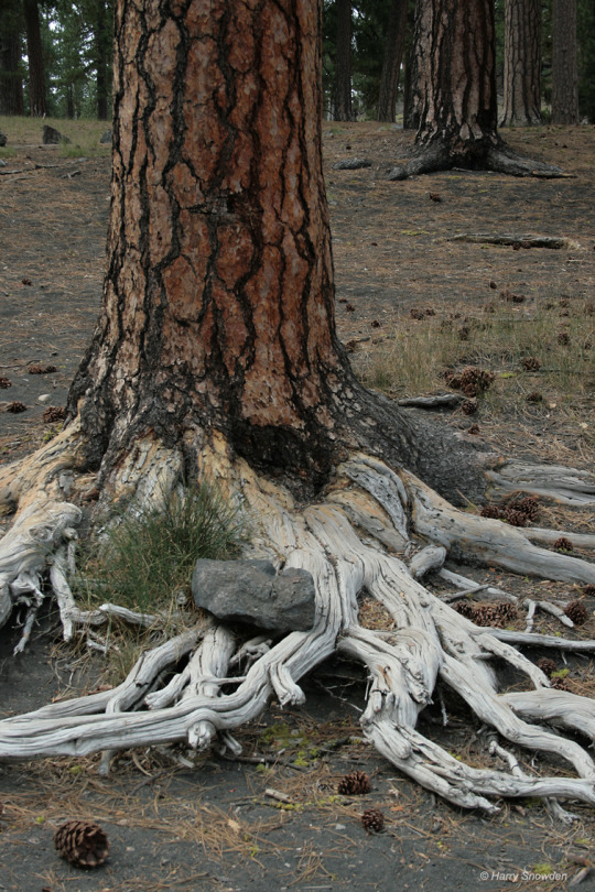
Cinder Cone Trail - Lassen Volcanic NP
Harry Snowden
#cinder cone trail#photographers on tumblr#national Parks#Northern California#volcanic#pnw#hiking#nature photography#trees#original photographer
61 notes
·
View notes
Text
Photos & Paintings of Sunsets: Many Artists!
They say my sunset photos are in positions 17-20.
What’s not to love about these gorgeous works of art — photographs, paintings and other media. Once again I get to boost my fellow artists, and I am deeply honored to have my work displayed too. Thank you Fine Art America!
sunset mountains art
View On WordPress
#cinder cones#nature#northern Arizona#olympusphotography#photography#San Francisco Volcanic Field#sunsets
0 notes
Photo
Matteo Badini
#volcanoes#volcano#lava flow#cinder cones#cinder cone#mountains#hills#rocks#volcanic rocks#scenery#nature#landscape#nature photography#curators on tumblr#aesthetic#geology#volcanology
1 note
·
View note
Text


HiPOD 11 Sept 2023: Hills in Coprates Chasma
In this image, we see two well developed cones, most likley the Martian equivalents of cinder cones, which are part of wider volcanic field in Valles Marineris. A stereo image might provide insight about their shape and size. Observations like this might provide hints about explosive conditions at the time of eruption and also why explosive volcanism occured in this area.
ID: ESP_074115_1670
date: 19 May 2022
altitude: 266 km
NASA/JPL-Caltech/UArizona
251 notes
·
View notes
Text

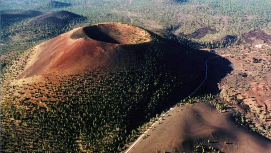
The Cinder Cone, Lassen Volcanic National Park, California, as seen from the start of the trail up the side of the cone (August 2023). The trail looks easy, but it's deceptive — it's a steep 700' elevation change scramble up a loose combination of dirt and dry unstable basalt, and it's very exposed. And that trail is in fact much wider and bigger than it looks (you can see a person on it about halfway up if you look hard enough). But it's definitely worth it…
132 notes
·
View notes
Text

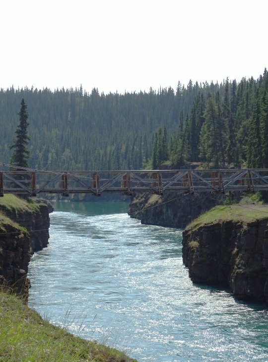


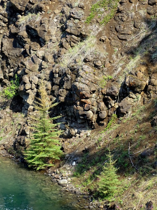

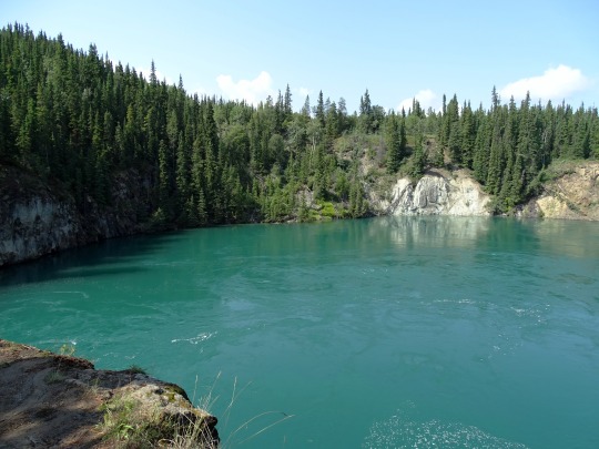

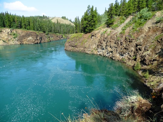
Miles Canyon, YT (No. 4)
The lava flows and cinder cones in the Alligator Lake volcanic complex southwest of Whitehorse are the greatest accumulation of these rocks.
The Miles Canyon Basalts were thought to be Pleistocene age. However, geological investigations supported by geochronological analyses indicate that these rocks are much older. The 'type' Miles Canyon flows along the Yukon River are ~8.4 million years old (Miocene) and the Alligator Lake flows are ~3.2 million years old (Pliocene). The Alligator Lake cones may be younger but have been affected by glaciation so are not entirely post-glacial in age.
Source: Wikipedia
#Miles Canyon#Miles Canyon Basalt#geology#volcanic rocks#travel#original photography#vacation#tourist attraction#landmark#landscape#Canada#Yukon#Whitehorse#the North#subalpine fir#river bank#summer 2023#forest#woods#flora#nature#countryside#cityscape#Yukon River#Miles Canyon Suspension Bridge#architecture#engineering
22 notes
·
View notes
Text
July 27: Take Your Houseplants For A Walk Day
Before moving into the Koopa Kingdom’s castle, Luigi took pride in the garden he cultivated next to his and Mario’s little house.
Most of his plants were useful herbs and power ups, although his eclectic tastes have led to him getting miniature Piranha Plants (who were such good girls as they wanted pets more than anything), some Nippers (who kept the garden mosquito-free as he waited for them to mature), and other various plants he and his brother encountered.
And then he married Bowser.
One thing led to another, but Luigi held little regret in practically transplanting his whole garden into a climate controlled greenhouse- practically screaming to anyone who knew Luigi that he had every intention of staying.
And he did, spending many years adding to the collection with potted native species like Heart Plants (gifted to him by Mario after a year in the Koopa Kingdom) and Calm Volcano Lotuses (as a wedding gift from Peach).
However, unlike the species of his original garden, native plants had a particularity of needing to be exposed to regular high temperatures and annual additions of volcanic soot. Both are unfortunately (or fortunately for him) not found inside the castle.
So, Luigi decided to break out the old wheelbarrow and wheel each potted plant outside the castle walls, placing them near the local cinder cones every week.
It was a routine he did alone- until Roy took up an interest in gardening.
While definitely a bit of a muscle head, what with his enthusiasm for fighting, the Koopaling had been equally fascinated by the quieter activities of feeding, potting, watering, and pruning of plants.
When asked, Roy would insist that it was because of the native plants- how they tended to have their own violent spunk in order to survive their natural habitat.
But, in the moments where he and Luigi were enclosed in the Royal Greenhouse, his attention lay with the plainer vegetation- herbs, berry bushes, nut trees, and especially sunflowers.
Privately, Luigi thinks it’s because sunflowers are the only large plants that don’t try to eat people’s faces off, but he’s sure that there’s another reason as well.
Whatever it may be, Luigi is likely the first to notice how the other Koopalings started to poke around as well- usually taking the time to ‘bother’ Roy with questions about certain plants, maybe even asking to help (which usually consists of collecting fruits and nuts).
Still, he loved the way Roy lit up at each question. How his eyes sparkled with seldom-seen excitement, and how his grin was more relaxed than the sharp-toothed smiles he gave to opponents.
It was little things like that which had him and his husband watch the kids in silence, sharing looks of fondness as the kids got absorbed into their bubble in the garden.
It was the main reason that Luigi loved and prided in his garden, and the motivation which he drew on for days that were a bit more difficult.
It was what made him wonder if he ever could get any happier than in moments like this.
70 notes
·
View notes
Note
OH OH OK I GOT A QUESTION. whats the youngest like, volcano in the san francisco volcanic field
Sunset Crater!!!!!!!!! My favorite volcano everrrrrr, it erupted around the year 1050 so it's very recent in geologic terms - it's about 950 years old. It also means the San Francisco volcanic field is still active (not Sunset Crater though, that is a cinder cone so they only erupt once and then it's over - we call that a monogenetic volcano). Sunset Crater National Monument is managed by the NPS near Flagstaff. The red is from oxidized basalt (contains iron). Also, the Sinagua people in the area witnessed the eruption, safely evacuated, and eventually relocated to areas like Wupatki and Walnut Canyon due to volcanic soil allowing the areas to be farmable. I am a volcanologist so I understand the in-depth geology of Sunset Crater better than the historical and cultural significance, but I do recommend doing your own reading on it if that interests you too cuz I always think it's incredibly neat how human and volcanoes are so intertwined with one another, one way or another.
btw...Sunset Crater also makes a lot of "cameos" in my story Uranium Rush cuz the fictional town of Sandstone Springs is nearby it. If you ever see me draw a reddish looking volcano cone in the desert that isn't the San Francisco Peaks (Very large, jagged, has snow) it's most likely Sunset Crater! Anyways...from my understanding, every hill in Northeast Arizona is actually a cinder cone, so I think that is super neat...and there's like 600 of them in the area.
Also, SP Crater is the 2nd youngest at about 5.5k - 6.0k years old, still seems pristine bc its crater rim is compose of resistant lava. (Sunset Crater has a tiny bit of crater collapse which you can see on the left side in the previous image)

Thank you so much for the ask!
16 notes
·
View notes
Text
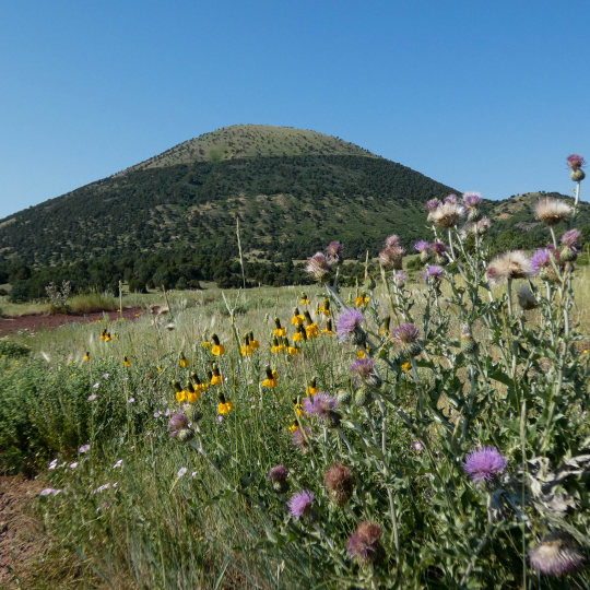
Capulin is a classic cinder cone volcano. The eruption of Capulin, approximately 60,000 years ago, was one of the most recent eruptions in the Raton-Clayton Volcanic Field (RCVF). Overall, the RCVF is considered dormant and individual volcanic centers within the field, like Capulin, are considered extinct.

#New Mexico#what a view#OptOutside#roadtrip#travel#daytrip#nature#geology#whataview#scenic#earthpix#explore#landscape#naturelovers#Raton#volcanic#landscapephotography#HighDesert
8 notes
·
View notes
Text
Landscape Language
Cinder cone (noun) – a steep hill formed by accumulation of solidified fragments of lava around a volcanic vent.
Mount Rainier is not the only volcano in the park but has several satellite volcanoes surrounding it. About 105,000 years ago new vents opened on the lower northwest flank of Mount Rainier and lava flows of basaltic andesite (hotter, more fluid magmas than typical for Mount Rainier) spread across the Spray Park and Mist Park areas from cinder cones preserved as Echo and Observation Rocks. The vents were probably fed from a great depth rather than laterally from the same system that fueled Mount Rainier’s eruptions.
NPS/S. Redman Photo of Observation and Echo Rocks viewed from the Sunrise area. ~kl
45 notes
·
View notes
Text

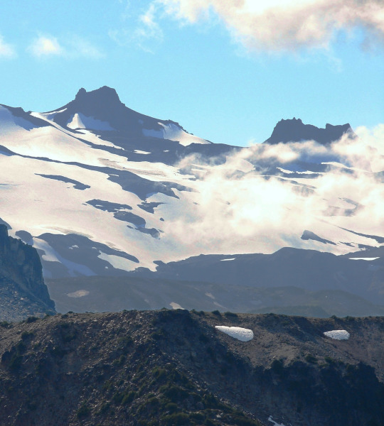
Vilyuchinsky, or Vilyuchik, is a steep-sided Pleistocene-to-Holocene stratovolcano south of Avachinsky Bay. Deep erosional gullies dissect the flanks, with Lava domes and young basaltic cinder cones at its base. Most of the growth of the volcano took place during the late Pleistocene. The last significant eruption took place from the summit crater about 10,000 years ago, producing a moderate airfall deposit and a lava flow. Landslides and rock avalanches have affected habited areas.
This volcano is located within the Volcanoes of Kamchatka, a UNESCO World Heritage property.
Smithsonian Institution - Global Volcanism Program
12 notes
·
View notes
Photo

Cinder Cone - Lassen Volcanic NP
Harry Snowden
#photographers on tumblr#california#pnw#cinder cone trail#national parks#Lassen Volcanic National Park#wilderness#hiking#adventure
39 notes
·
View notes
Text

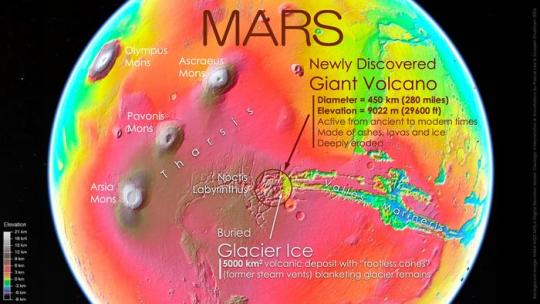

Giant volcano discovered on Mars
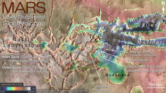
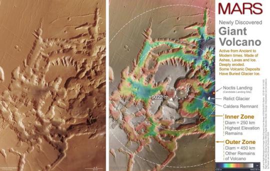
In a groundbreaking announcement at the 55th Lunar and Planetary Science Conference held in The Woodlands, Texas, scientists revealed the discovery of a giant volcano and possible sheet of buried glacier ice in the eastern part of Mars’ Tharsis volcanic province, near the planet’s equator. Imaged repeatedly by orbiting spacecraft around Mars since Mariner 9 in 1971 - but deeply eroded beyond easy recognition, the giant volcano had been hiding in plain sight for decades in one of Mars’ most iconic regions, at the boundary between the heavily fractured maze-like Noctis Labyrinthus (Labyrinth of the Night) and the monumental canyons of Valles Marineris (Valleys of Mariner) (Fig. 1).
Provisionally designated “Noctis volcano” pending an official name, the structure is centered at 7° 35' S, 93° 55' W. It reaches +9022 meters (29,600 feet) in elevation and spans 450 kilometers (280 miles) in width. The volcano’s gigantic size and complex modification history indicate that it has been active for a very long time. In its southeastern part lies a thin, recent volcanic deposit beneath which glacier ice is likely still present. This combined giant volcano and possible glacier ice discovery is significant, as it points to an exciting new location to study Mars’ geologic evolution through time, search for life, and explore with robots and humans in the future (Fig.2).
“We were examining the geology of an area where we had found the remains of a glacier last year when we realized we were inside a huge and deeply eroded volcano,” said Dr. Pascal Lee, planetary scientist with the SETI Institute and the Mars Institute based at NASA Ames Research Center, and the lead author of the study.
Several clues, taken together, give away the volcanic nature of the jumble of layered mesas and canyons in this eastern part of Noctis Labyrinthus. The central summit area is marked by several elevated mesas forming an arc, reaching a regional high and sloping downhill away from the summit area. The gentle outer slopes extend out to 225 kilometers (140 miles) away in different directions. A caldera remnant – the remains of a collapsed volcanic crater once host to a lava lake – can be seen near the center of the structure. Lava flows, pyroclastic deposits (made of volcanic particulate materials such as ash, cinders, pumice and tephra) and hydrated mineral deposits occur in several areas within the structure’s perimeter (Figs. 3, 4 and 5).
“This area of Mars is known to have a wide variety of hydrated minerals spanning a long stretch of Martian history. A volcanic setting for these minerals had long been suspected. So, it may not be too surprising to find a volcano here,” explained Sourabh Shubham, a graduate student at the University of Maryland’s Department of Geology and the study’s co-author. “In some sense, this large volcano is a long-sought ‘smoking gun’”.
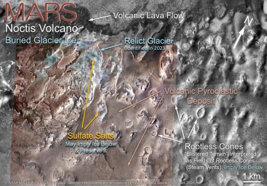
In addition to the volcano, the study reports the discovery of a large, 5000 square kilometer (1930 square mile) area of volcanic deposits within the volcano’s perimeter presenting a large number of low, rounded and elongated, blister-like mounds. This “blistered terrain” is interpreted to be a field of “rootless cones,” mounds produced by explosive steam venting or steam swelling when a thin blanket of hot volcanic materials comes to rest on top of a water or ice-rich surface (Figs. 3 and 6).
Just a year ago, Lee, Shubham and their colleague John W. Schutt had identified the spectacular remains of a glacier - or “relict glacier” - through a sizeable erosional opening in the same volcanic blanket, in the form of a light-toned deposit (LTD) of sulfate salt with the morphologic traits of a glacier. The sulfate deposit, made mainly of jarosite, a hydrous sulfate, was interpreted to have formed when the blanket of volcanic pyroclastic materials came to rest on a glacier and reacted chemically with the ice. Breached rootless cones identified in the current study show similar occurrences of polyhydrated sulfates, further suggesting the blistered volcanic blanket may be hiding a vast sheet of glacier ice underneath it (Fig. 6).
The Noctis volcano presents a long and complex history of modification, possibly from a combination of fracturing, thermal erosion, and glacial erosion. Researchers interpret the volcano to be a vast shield made of layered accumulations of pyroclastic materials, lavas, and ice, the latter resulting from repeated buildups of snow and glaciers on its flanks through time. As fractures and faults eventually developed, in particular in connection with the uplift of the broader Tharsis region on which the volcano sits, lavas began to rise through different parts of the volcano, leading to thermal erosion and removal of vast amounts of buried ice and the catastrophic collapse of entire sections of the volcano.
Subsequent glaciations continued their erosion, giving many canyons within the structure their present distinctive shape. In this context the “relict glacier” and the possible buried sheet of glacier ice around it, might be remnants of the latest glaciation episode affecting the Noctis volcano.
But much about the newly discovered giant volcano remains a mystery. Although it is clear that it has been active for a long time and began to build up early in Mars’ history, it is unknown how early exactly. Similarly, although it has experienced eruptions even in modern times, it is unknown if it is still volcanically active and might erupt again. And if it has been active for a very long time, could the combination of sustained warmth and water from ice have allowed the site to harbor life?
As mysteries surrounding the Noctis volcano continue to puzzle scientists, the site is already emerging as an exciting new location to study Mars’ geologic evolution, search for life, and plan future robotic and human exploration. The possible presence of glacier ice at shallow depths near the equator means that humans could potentially explore a less frigid part of the planet while still being able to extract water for hydration and manufacturing rocket fuel (by breaking down H2O into hydrogen and oxygen).
“It’s really a combination of things that makes the Noctis volcano site exceptionally exciting. It’s an ancient and long-lived volcano so deeply eroded that you could hike, drive, or fly through it to examine, sample, and date different parts of its interior to study Mars’ evolution through time. It has also had a long history of heat interacting with water and ice, which makes it a prime location for astrobiology and our search for signs of life. Finally, with glacier ice likely still preserved near the surface in a relatively warm equatorial region on Mars, the place is looking very attractive for robotic and human exploration,” said Lee.
This study was conducted using data from NASA’s Mariner 9, Viking Orbiter 1 and 2, Mars Global Surveyor, Mars Odyssey, and Mars Reconnaissance Orbiter missions, as well as ESA’s Mars Express mission. Special appreciation is expressed to their instrument teams for acquiring the various datasets used in this study. Use of the open NASA Planetary Data System, Mars Quickmap, Mars Trek, and Google Mars online data visualization tools was also key in enabling the study.
IMAGE 1....A giant volcano hiding in plain sight in one of Mars’ most iconic regions. Thenewly discovered giant volcano on Mars is located just south of the planet’s equator, in Eastern Noctis Labyrinthus, west of Valles Marineris, the planet’s vast canyon system. The volcano sits on the eastern edge of a broad regional topographic rise called Tharsis, home to three other well-known giant volcanoes: Ascraeus Mons, Pavonis Mons, and Arsia Mons. Although more eroded and less high than these giants, the newly discovered volcano rivals the others in diameter, which is about 450 km (280 miles) (red dashed circle in this picture). Possible buried glacier ice is also reported under a relatively recent volcanic deposit within the perimeter of the eroded volcano, making the area attractive for the search for life and future robotic and human exploration. Credit NASA/USGS Mars globe. Geologic interpretation and annotations by Pascal Lee and Sourabh Shubham 2024
IMAGE 2....Newly discovered giant volcano is located in the “middle of the action” on Mars. Topographic map showing the iconic location of the Noctis volcano between the largest volcanic and canyon provinces on Mars. Credit NASA Mars Global Surveyor (MGS) Mars Orbiter Laser Altimeter (MOLA) digital elevation model. Geologic interpretation & annotations by Pascal Lee and Sourabh Shubham 2024
IMAGE 3....Topographic map of the Noctis volcano. The Noctis volcano does not present the conventional cone shape of a typical volcano because a long history of deep fracturing and erosion has modified it. However, upon close inspection, key features indicative of a volcano are recognizable. Within the “inner zone” delineating the highest elevation remains of the volcano, an arc of high mesas marks the central summit area, culminating at +9022 m (29,600 ft). Preserved portions of the volcano’s flanks extend downhill in different directions to the outer edge of the “outer zone,” 225 km (140 miles) away from the summit area. A caldera remnant – the remains of a collapsed volcanic crater once host to a lava lake – can be seen near the center of the structure. Lava flows, pyroclastic deposits (made of volcanic particulate materials such as ash, cinders, pumice and tephra) and hydrothermal mineral deposits occur in several areas within the perimeter of the volcanic structure. The map also shows the rootless cone field and possible extent of shallow buried glacier ice reported in this study, in relation to the “relict glacier” discovered in 2023. Noctis Landing, a candidate landing site for future robotic and human exploration, is also shown. Credit NASA Mars Reconnaissance Orbiter (MRO) Context Camera (CTX) mosaic and Mars Global Surveyor (MGS) Mars Orbiter Laser Altimeter (MOLA) digital elevation model. Geologic interpretation & annotations by Pascal Lee & Sourabh Shubham 2024
IMAGE 4....Detailed Mars data analysis revealed the Noctis volcano.
Detailed analysis of the altimetry of the region using NASA’s Mars Global Surveyor (MGS) Mars Orbiter Laser Altimeter (MOLA) data, in combination with high resolution imaging data from NASA’s Mars Reconnaissance Orbiter (MRO) High Resolution Imaging Science Experiment (HiRISE) and Context Imager (CTX), and from the European Space Agency’s Mars Express (MEX) High Resolution Stereo Camera (HRSC) enabled the discovery of the Noctis volcano. In addition to the volcano’s summit, caldera remnant, and inner and outer zones, the topographic map on the right shows the “relict glacier” discovered in 2023 and Noctis Landing, a candidate landing site for future robotic and human exploration. Credit Left: Mars Express HRSC color mosaic © ESA/DLR/FU Berlin CC BY-SA 3.0 IGO; Right: Background image: same as Left; NASA MGS MOLA digital elevation model. Geologic interpretation and annotations by Pascal Lee and Sourabh Shubham 2024
IMAGE 5....Noctis volcano in 3D. Anaglyph image showing portions of the Noctis volcano’s 250 km (155 mile) diameter inner zone of high elevation remains, and 450 km (280 mile) diameter outer zone of other remains associated with the volcano. In addition to the volcano’s summit, caldera remnant, and inner and outer zones, this 3D map shows the “relict glacier” discovered in 2023 and Noctis Landing, a candidate landing site for future robotic and human exploration. Credit Mars Express anaglyph (3D) mosaic © ESA/DLR/FU Berlin CC BY-SA 3.0 IGO. Geologic interpretation and annotations by Pascal Lee and Sourabh Shubham 2024
IMAGE 6....Possible buried glacier ice near the base of the Noctis volcano. A well-preserved volcanic lava flow and pyroclastic deposit in the southeastern part of the Noctis volcano suggest that the volcano remained active even in relatively recent times. The pyroclastic deposit presents “blisters” at its surface, interpreted as “rootless cones” or steam vents produced when the hot pyroclastic materials came in contact with H2O ice. Breaches in the pyroclastic deposit reveal light-toned deposits (LTDs) of sulfate salts, expected products of chemical reactions between pyroclastic materials and H2O ice. The largest LTD of sulfates in this area had already been described as a “relict glacier,” as it presents a wide range of morphologic traits specific to glaciers, suggesting that glacier ice might still be preserved, only protected under a thin layer of sulfate salts. By extension, the rootless cones and other sulfate deposits in this area may be blanketing even more glacier ice. Credit NASA Mars Reconnaissance Orbiter (MRO) High Resolution Imaging Science Experiment (HiRISE), Context Imager (CTX), and Compact Reconnaissance Imaging Spectrometer for Mars (CRISM). Geologic interpretation and annotations by Pascal Lee and Sourabh Shubham 2024
4 notes
·
View notes
Video
Wizard Island by James Marvin Phelps
Via Flickr:
Wizard Island Crater Lake National Park Oregon July 2023 Wizard Island is a captivating natural wonder nestled within the pristine waters of Crater Lake National Park. Located in the southern part of Crater Lake. This enchanting island is a volcanic cinder cone that emerged over 7,000 years ago during a series of volcanic eruptions. Rising majestically from the deep, crystal-clear waters of the lake, Wizard Island is shrouded in an aura of mystique, drawing visitors from far and wide to witness its otherworldly beauty. The island's unique conical shape, covered in lush greenery and dotted with fumaroles, lends an ethereal charm to the landscape. Accessible by boat, exploring Wizard Island offers a magical experience, allowing travelers to connect with the region's ancient geological history and enjoy breathtaking vistas surrounding this mystical gem within Crater Lake National Park.
#oregon#national park#crater lake#volcano#lake#crater#water#wizard island#daytime#clouds#landscape#nature#beauty#outdoors#travel#james marvin phelps photography#flickr
10 notes
·
View notes
Text
Inside the Cinder Cone, with Mt Lassen lurking off in the distance, Lassen Volcanic National Park, California (August 2023).
81 notes
·
View notes
Text

Cinder Cone Trail, Lassen Volcanic National Park
2 notes
·
View notes
Last Seen Blogs

jj-lives
JJLives

dykesfordonnatartt
Untitled

prince-raisins-art
WE OBJECTIFY MEN HERE SIR.

darkalinas
no. 1 villain protector

carlawrap-blog
Carlawrap | Car Wrap Shop at www.carlawrap.com