
itssedimentary
It's Sedimentary
I'm a 25-year-old geology Ph.D. Candidate who loves rocks and wants other people to love them too! Here you'll find a diverse collection of all things geology and natural history related. It's sedimentary, my dear Watson!
312 posts
Don't wanna be here? Send us removal request.
Last Seen Blogs

vandinh126
Untitled

sasykes
Untitled

gavin-david-free
dank memes only

tifa-lockhart15
Tifa Lockh4rt

reisaart
Reisaart
Video
youtube
Could an Earthquake Destroy Disneyland?
Disneyland may be one of the happiest places on Earth, but it’s also smack in the middle of California earthquake country. The San Andreas fault runs through nearly the entirety of California and has produced many great earthquakes.
The San Andreas fault defines a tectonic boundary between the Pacific Plate and the North American plate. These plates are trying to move past one another, and in doing so, produce earthquakes.
The southern portion of the San Andreas fault has not produced a great earthquake in historic times, and many seismologists anticipate the next big quake will occur in this area---putting at risk the greater Los Angeles area.
In this video, learn more about the San Andreas fault, earthquakes and the risks they pose to places like Disneyland.
#geology#science#disney#san andreas#earthquake#california#stem#disneyland#san andreas fault#natural hazards#mickey mouse
8 notes
·
View notes
Photo
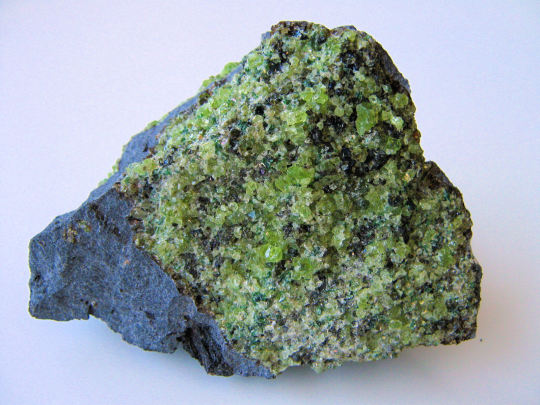
A journey to the center of the Earth | Peridotite xenoliths
You don’t need to go on a Jules Verne journey down to the center of the Earth, sometimes the center of the Earth is brought up to us!
These rocks are examples of peridotite xenoliths. A xenolith is a fragment of rock that becomes enveloped by magma without being melted or incorporated into it. In these photos, there are abundant fragments of xenolith peridotite surrounded by basalt. Peridotite is a rock composed of the minerals olivine and pyroxene, and it is the dominant rock composing the upper-part of Earth’s mantle.
As this basaltic magma was quickly rising through the mantle and the crust, it tore away solid chunks of mantle and brought them up in-tact to the surface. So when you look at these xenoliths, you’re looking at the composition of the Earth at tens to hundreds of kilometers depth!
These samples come from the San Carlos volcanic field near the town of Peridot, AZ. (Gem-quality olivine is called ‘peridot,’ so you can see where the town gets its name!) The San Carlos volcanic field covers a 50 km2 area of cinder cones and lava flows and is one of the world’s leading sources in gem-quality peridot.
All images by author
#geology#science#volcano#volcanology#peridot#olivine#mantle#peridotite#gem#stem#arizona#volcanic field#petrology
456 notes
·
View notes
Link
My undergrad advisor has a really interesting article in the New Yorker about the recent earthquakes that have struck Mexico---turns out it’s not the type of faulting you would expect in a subduction zone.
18 notes
·
View notes
Photo

Can you find the unconformity?
An unconformity is an erosional or non-depositional gap in the geologic record. They typically form when an older layer is subject to a period of erosion before the deposition of new sediments. This road cut near Payson, Arizona shows a pretty cool unconformity. Can you find where it is? Check the jump below to see if you’re correct!
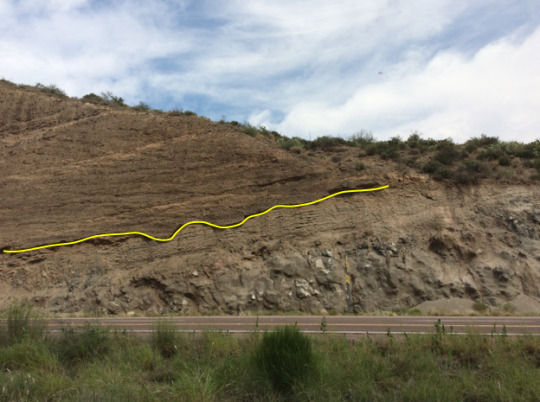
The yellow line shows where the unconformity is in the outcrop. Did you identify it correctly?
Below the unconformity, there is an andesite overlain likely by a paleosol. Above the unconformity is valley fill produced from the nearby eroding mountains. You’ll notice that the unconformity isn’t a totally planar surface; the valley fill cut into pockets of the former surface, giving the unconformity a wavy appearance.
Another cool thing about this outcrop is that you can see the units aren’t actually horizontal, meaning they must have experienced tilting due to regional tectonic activity!
Image by author
11 notes
·
View notes
Video
youtube
Why are the Rocks of Sedona, Arizona Red?
Ever wondered why the rocks of Sedona are so vibrantly red?
I made this video for Arizona State University’s Science Showcase competition, I’d greatly appreciate anyone who can view/share! Plus learning about geology is fun!
#geology#science#sedona#arizona#stem#earth science#sedimentary#iron#az#erosion#video#science showcase
12 notes
·
View notes
Video
youtube
Could a Sinkhole Swallow Walt Disney World?
Sinkholes are all too common of an occurrence in Florida, frequently swallowing cars and houses. The state of Florida has so many sinkholes because it is a karst landscape, composed primarily of limestone bedrock.
So what are the odds that a sinkhole appears at Walt Disney World? What if I were to tell you there’s already a massive sinkhole there... watch to learn more!
#geology#science#disney#sinkhole#walt disney world#disney world#florida#limestone#karst#earth science#stem#magic kingdom#epcot#original#geology of disney
15 notes
·
View notes
Photo

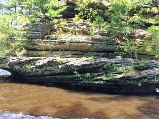
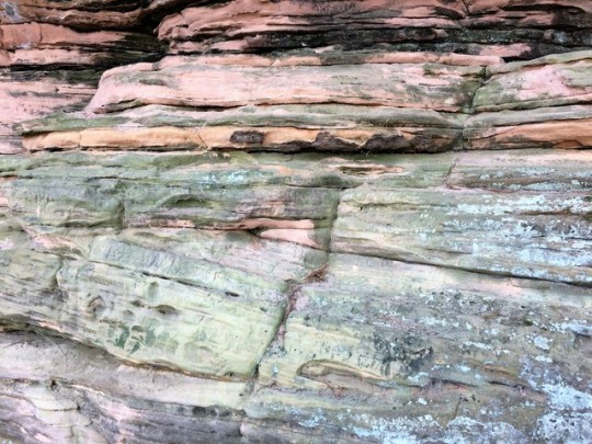
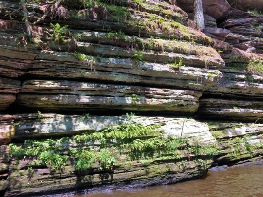
The Wisconsin Dells | An Ice Age and modern water park
Despite its location in the heart of Wisconsin, the Wisconsin Dells is today known as the “Waterpark Capital of the World.” However, it was its rocks---the actual Dells---that first made it a popular Midwest tourist destination back in the 1800s.
The Wisconsin Dells---which come from the French word dalles, or narrows---is a 5 mile stretch of gorges and rock formations along the Wisconsin River. The rocks are composed of Cambrian sandstone deposited around 500 million years ago.
At that time, present-day Wisconsin lay in the southern tropics, and the Dells were in a nearshore environment by shallow tropical seas that waxed and waned over the area. The sandstones were first deposited as wind-blown dunes. (The cross-bedding you can see in the rocks records the orientations that the winds were blowing.) Toward the end of the Cambrian, shallow seas began encroaching the region and deposited marine sandstones over the aeolian (wind-formed) deposits.
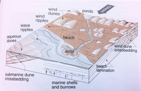
Figure from Roadside Geology of Wisconsin, Dott and Attig
However, it was a very long time in between when these rocks were deposited and when they became the Dells that we recognize today.
During the last Ice Age around 19,000 years ago (when Wisconsin was in its present-day location), the Green Bay lobe of the Laurentide ice sheet ponded meltwater and dammed the Wisconsin River to form Glacial Lake Wisconsin. At its greatest extent, this lake covered much of central Wisconsin and was the size of modern-day Great Salt Lake.
When the glaciers began to retreat 14,000 years ago, an ice dam holding back lake waters catastrophically failed, and Glacial Lake Wisconsin fully drained within the span of about a week. This rush of water surged through the Dells area and deeply incised the poorly-cemented Cambrian sandstones to create a series of gorges---the Wisconsin Dells that we see today.
It’s quite a strange twist of fate that an area so rapidly formed by raging waters is now home to guests who play in them all day!
All images by author
#geology#science#earth science#wisconsin dells#wisconsin#dells#sandstone#midwest#original#glacial lake wisconsin#glacier#ice age#cambrian#stem
83 notes
·
View notes
Video
youtube
The Geology of Disney’s Animal Kingdom
Think there’s no geology behind theme parks? Think again! In this video, I’ll teach you about the real-life geology behind popular attractions at Disney’s Animal Kingdom.
Learn about the formation of the Himalaya from Expedition Everest, the End-Cretaceous mass extinction from Dinosaur and the sandstone peaks of the Zhangjiajie National Forest Park from Pandora’s floating mountains!
If you haven’t already, check out the sister video I made about the geology behind some of the attractions at the Disneyland Resort!
#geology#science#disney#walt disney world#animal kingdom#himalaya#structural geology#expedition everest#dinosaur#cretaceous#mass extinction#meteorite impact#volcanism#volcanoes#pandora#avatar#floating mountains#geomorphology#china#chicxulub#disney world#original#stem education#stem outreach#stem#theme park
63 notes
·
View notes
Video
instagram
More augmented reality sandbox work!
4K notes
·
View notes
Video
youtube
A few months ago, I made a blog post about The Geology of Disneyland. I’ve now turned that content into a video, so please do watch and enjoy!
#geology#science#disneyland#disney#stem#matterhorn#monument valley#hoodoo#hoodoos#erosion#differential erosion#big thunder mountain#radiator springs racers#pangaea
11 notes
·
View notes
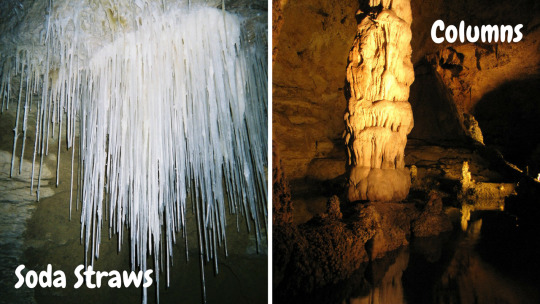
Photo
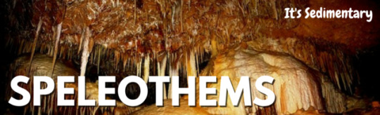
Speleothems
Imagine that there’s a faucet that’s slowly dripping. If the faucet is left to drip long enough, you’ll notice that it will leave behind deposits from the dissolved minerals in the water. Now, imagine if you left your faucet dripping long enough to create a mineral deposit that was a meter-plus tall. This process is the basic mechanism behind how speleothems form.

Speleothems are cave formations built by secondary mineral deposition. The majority of speleothems are composed of calcium carbonate (CaCO3) derived from the limestone or dolostone bedrock that comprise a karst.
As rainwater interacts with CO2 in the atmosphere and in soils, it becomes weakly acidic. When this water travels down through calcium carbonate bedrock, it reacts with and dissolves the bedrock via carbonate dissolution reactions. When the solution reaches the cave, the lower partial pressure in the cave will cause degassing and drive precipitation of CaCO3, developing speleothems over time.

The best-known types of speleothems are dripstones formed by drips of mineral saturated water, just like from a leaky faucet. Drip by drip, dripstones grow either from the roof down or the ground up. Typically, a dripstone will grow less than 10 cm every thousand years. Stalactites hang down from the ceiling, while stalagmites grow up from the ground. (An easy way to remember the difference is that stalactites hold tight on the ceiling while stalagmites might grow to reach the roof.)
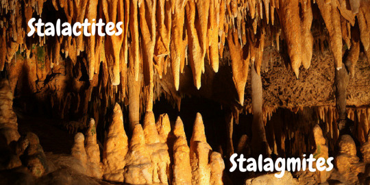
Stalactites and stalagmites both come in various forms, depending on the supply and location of their water source. The most delicate type of stalactites are soda straws, which are very long, thin and cylindrical in shape. If a stalactite and a stalagmite grow to reach one another, they will fuse to create a column. Columns reach from the floor to the roof of a cave, making them the most formidable of all speleothems.
In addition to dripstones, flowstones are another type of speleothem. Flowstones are deposited from thin sheets of flowing water, rather than discrete drops. Flowstones tend to coat cave walls and floors. Deposits can even form ‘draperies’ under hanging portions of a wall. These draperies may be layered and slightly transparent, giving them the moniker of cave “bacon.”
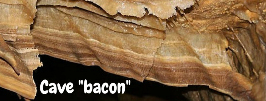
Photo sources in order: [x], [x], [x], [x], [x], [x], [x]
#geology#science#cave#karst#speleothem#speleothems#stalagmite#stalactite#dripstone#calcium carbonate#original#cave bacon#flowstone#limestone
76 notes
·
View notes
Photo
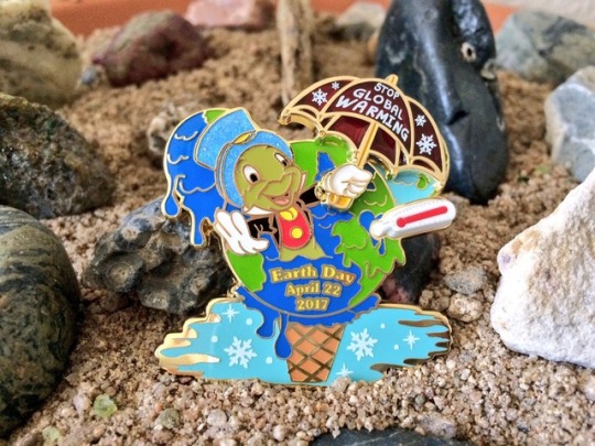
Happy Earth Day 2017! More than ever, we must educate others on the realities of climate change and global warming. We only have one planet, let's be kind to our home! 🌎🌍🌏
21 notes
·
View notes
Photo
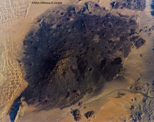
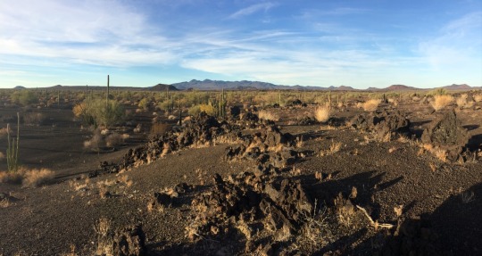
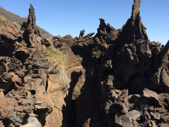
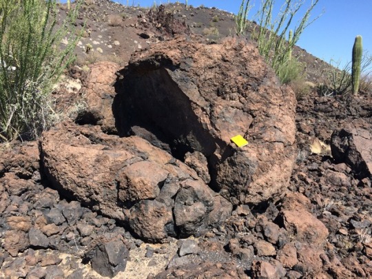
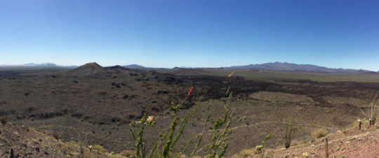
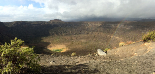
Pinacate Volcanic Field
Located in far northwest Sonora, Mexico, the Pinacate volcanic field comprises a 1,500 km2 area of Pleistocene lava flows with over 400 cinder cones and 8 maars. The volcanoes in the Pinacate are monogenetic---meaning they erupt only once and each have a unique magmatic signature. The field today is part of El Pinacate and Gran Desierto de Altar Biosphere Reserve and is also a UNESCO World Heritage Site.
The eastern portion of the field---which is accessible by a vehicle tour route---contains the youngest cones and is mantled by an extensive tephra deposit. One of the most impressive features on the vehicle route is a large maar caldera, Crater Elegante, formed 32 thousand years ago in an explosive eruption when groundwater interacted with magma. The caldera measures nearly a mile in diameter and is the largest maar in the field.
The cinder cones are accompanied by extensive basaltic lava flows, some of which form spiky stiff peaks. Due to the arid, desert setting of the field, most of the cones have experienced very little erosion and retain a relatively youthful morphology. Extensive dune fields surround the volcanic complex, providing a stark visual contrast to the dark basalt rocks.
Top image from Dan Lynch, all other images by author
#geology#science#volcano#volcanoes#pinacate volcanic field#pinacate#earth science#original#volcanology#mexico#sonora#desert
192 notes
·
View notes
Photo

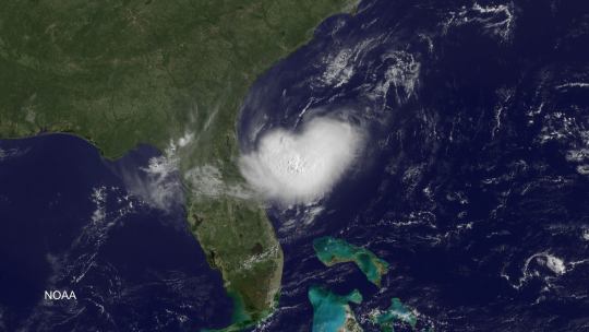
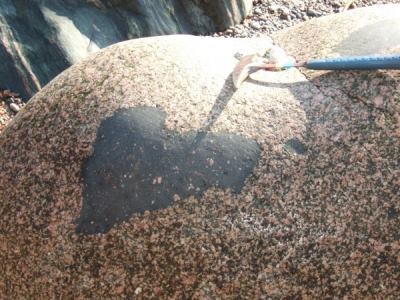
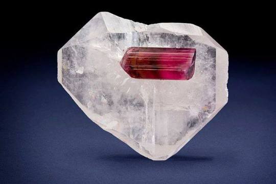

Geological hearts
Since it’s Valentine’s day today and love is being celebrated around our beautiful Planet and sole home, I thought I’d share a few Earthly wonders. The first is a spatter of basaltic lava ejected from Kilauea, that mighty shield of the Hawaiian Isles, our second is a cloud above Florida snapped from space, our third is a xenolith, a chunk of foreign material carried up from the world’s depths by rising magma and erupted onto the surface. The fourth is a lush Brazillian piece measuring 7 x 6 x 2 cm and consisting of a 3cm gem rubellite tourmaline sitting on a quartz crystal and my last is a hole in some lava at Nakalele Point in Hawaii. Happy St Valentines to you all.
Loz
Image credit:
Lava Brad Lewis/Science Faction/Corbis
Cloud NOAA
Xenolith: James /BBC Scotland
Crystals: Joe Budd/Rob Lavinsky/iRocks.com
Nakalele: Coty Gonzalez
635 notes
·
View notes
Photo

GEOLOGY OF DISNEYLAND
Even before I finished my first geology class, I (jokingly) told people that I was going to be a Spanish-speaking geologist at Disney World. While the rocks of Disney may not exactly be real, we can still learn about the geologic formations they take their inspiration from. Here’s a look at a few of the geologically-inspired attractions at the Disneyland Resort in California and their real-life counterparts.
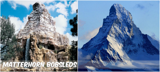
The Matterhorn Bobsleds, Disneyland’s original roller coaster, is directly modeled after Matterhorn mountain of the Swiss-Italian Alps. The Disneyland version of the mountain employs forced perspective and is exactly 100 times shorter than the original Matterhorn (which is 14,700 feet tall!). The real Matterhorn mountain is composed of the metamorphic rock gneiss. The Matterhorn--along with the rest of the Alps--originated during the break-up of the supercontinent Pangaea 200 million years ago. 100 million years after Pangaea broke into Laurasia (containing Europe) and Gondwana (containing Africa), a part of Gondwana broke off and collided with the European continent to become the Alps. The classic pyramidal shape of the Matterhorn mountain is relatively recent and was carved by glacial erosion over the last few million years. The Matterhorn is one of the world’s best examples of a “glacial horn” or “pyramidal peak,” which is produced when multiple glaciers diverge from a central point.
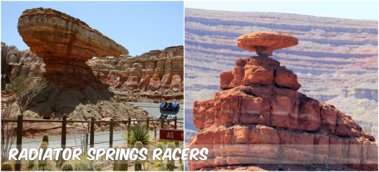
Radiator Springs Racers takes riders through the fictitious Cars city of Ornament Valley, scenically inspired by Monument Valley of Utah and Arizona. Along the ride you pass “Willy’s Butte,” which is modeled after “Mexican Hat” rock in Utah near Monument Valley. The rock resembles an upside down sombrero and the real version measures 60 feet wide across the top. From about 300 to 200 million years ago, the southwest was covered by shallow seas, and layers of siltstone, shale and sandstones were deposited. When the seas retreated and the area was uplifted, these sedimentary units were subject to erosion. The different hardnesses of shale and sandstone result in differential erosion--meaning rates of erosion will vary based on the different resistances of surface materials. Sandstone is more resistant--eroding away less quickly--and will form vertical cliff faces. Siltstone and shale are far less resistant and erode away faster to form gentle aprons of material. If a resistant rock like sandstone overlies a weaker rock like shale, the weaker rock will erode and undermine the rock above, resulting in these cool “upside-down” formations.
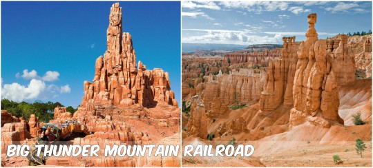
Big Thunder Mountain Railroad takes riders through scenery inspired by the hoodoos of Bryce Canyon National Park in Utah. Hoodoos are skinny spires of rock shaped like totem poles and are most commonly found in arid badland-like areas. Bryce Canyon National Park contains a greater concentration of hoodoos than anywhere else in the world, and many are up to 100 feet tall. The conglomerate, siltstone and sandstone rocks of the Bryce Canyon region were deposited from around 100 to 50 million years ago when an interior seaway covered the area. Once the seas retreated and the region was uplifted, the area experienced erosion. We can also thank differential erosion for the formation of these hoodoos, as they are composed of large layers of softer rock alternating with layers of more resistant rock. However, the primary weathering processes at work are freeze-thaw cycles. As water makes its way into vertical rock fractures, it will freeze and expand, further widening cracks. The repeated freeze-thaw cycles eventually causes portions to calve off, leaving behind tall totem-like spires.
Photo credits: Banner background [x] | Matterhorn Bobsleds [x] | Matterhorn mountain [x] | Radiator Springs Racers [x] | Mexican Hat rock [x] | Big Thunder Mountain Railroad [x] | Bryce Canyon hoodoos [x]
#geology#science#disney#disneyland#matterhorn#radiator springs racers#big thunder mountain#mountains#butte#hoodoo#alps#utah#bryce canyon#monument valley#arizona#route 66#attractions#rocks
16 notes
·
View notes
Text
Yes, climate change is real—and we’re causing it
Especially in the news as of late, there has been a lot of talk as to whether politicians “believe” in climate change. Framing the question like this makes it seem as though climate change is in the league of Santa Claus or the Easter Bunny—things that require belief for their existence. However, climate change doesn’t care whether or not we “believe” in it. Much like how the Earth is round, climate change is something that is regardless of how we feel about it. Global climate is warming, and we’re the ones that are directly responsible.
So how do we know that global climate has drastically warmed? Drilled ice cores from Antarctica yield CO2 records that serve as a proxy for global temperatures back in the geologic past. (Read more about paleoclimate proxies here.) Over the past 400,000 years, these ice cores show that CO2 values ranged from around 180 to 300 ppm, with the variability tracking glacial-interglacial cycles. In the late 1950s, the Mauna Loa Observatory began taking direct measurements of CO2 in the atmosphere. From this time to the present, CO2 values skyrocketed. Today, they are now off the charts and have surpassed 400 ppm. This is a drastic, unprecedented and indisputable rise in CO2 values and global temperature, and it has been directly caused by human activities.

CO2 values over the past 400,000 years to present. Image source: NASA
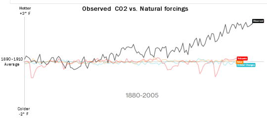
We can compare this trend in rising CO2 values to modeled CO2 trends if only natural forcings—orbital changes, volcanoes and solar effects—were at work. Over geologic time, these natural forcings have been important drivers of changes in CO2. However, as the graph below clearly shows, natural forcings at work today do not match the increase in CO2 values over the last century. Instead, natural forcings alone would support no changes in CO2 and global temperature.
However, if we instead look at only anthropogenic (human) forcings and the observed increase in CO2 concentrations, we begin to find a much clearer correlation. While land use, aerosols and ozone alone would actually stabilize or even decrease CO2 concentrations, greenhouse gas emissions follow---and even surpass---the observed CO2 trend. It is these greenhouse gases, emitted by humans, that are the primary driver of global warming.
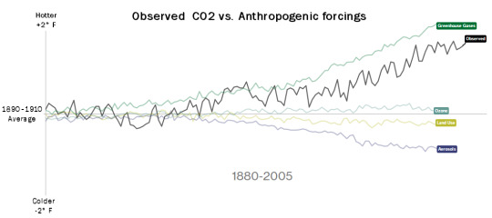
Collapse all these anthropogenic factors together, and now you have have a trend that tracks along well with the increase in CO2 concentrations over the last century.
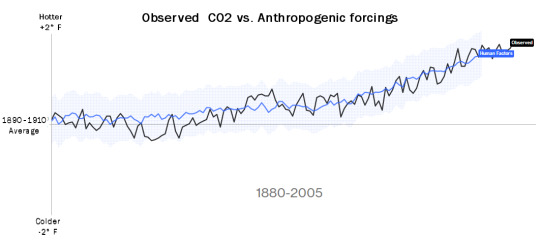
Include in the influences from both natural and anthropogenic forcings, and the trend even more closely matches the directly measured increase in CO2 concentrations and global temperatures.
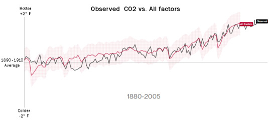
Based upon these individual components, greenhouse gases emitted by humans are directly responsible for climate change. CO2 concentrations show annual fluctuations based on when vegetation is “inhaling” or “exhaling” CO2, but the overall increase is indisputable. Strategies and policies to mitigate and adapt to climate change are needed immediately. As global temperatures continue to rise, continental ice sheets will melt and raise sea level, arid areas will become even more prone to droughts and national security concerns will reach new heights.
It is a small bit of comfort to know that the Earth is going to be just fine at the end of this. Over its 4.5 billion year history, the Earth been through a lot—meteorite impacts, massive volcanic eruptions, continental collisions, etc.—and it has come out just fine. However, it’s humans and the biosphere that will directly be at risk. If we don’t soon mitigate or reverse the effects of global warming, humans may find themselves victims of a sixth mass extinction.
So instead of “do you believe in climate change?”, questions now need to be, do we accept that climate change is an important issue? How are we going to mitigate or reverse its effects? Are we even aware of how severe its effects may be? Every time a politician denies the reality of climate change, they are putting all of us at risk. So please share this with your friends and family, write to or call your state’s government representatives and urge them to act upon the reality of climate change. The fate of humanity and the biosphere quite literally depends on it.
Global warming graphs adapted from Bloomberg and NASA
#geology#science#climate change#climate#climate science#fossil fuels#anthropogenic emissions#global warming#carbon dioxide#original
47 notes
·
View notes