#NW Coast Haida
Note
who's the formline-inspired fish for?
So I'm still fleshing the character out, but as befitting Chowder's successor, he's a cheerful goalie from the West Coast. In this case, he's from the Pacific NW, and he's First Nations (maternally; primarily Haida and Kwakwaka'wakw) and Alaska Native (paternally; primarily Inupiat, followed by Tlingit and Yup'ik). There's actually a rhyme and reason for why I mixed those specific groups.
If Chowder can do the splits on command, this dude can do a high kick in goalie pads.
Debating on whether he went to school at Shawnigan Lake or St. George's. Willing to have input from anyone from BC between the two.
1 note
·
View note
Photo
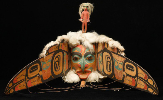


An assortment of anthropomorphic transformation masks created by Pacific Northwest Coast Indigenous peoples on the continent of North America.
#Transformation masks#NW Coast Haida#Movable masks#Kwakiutl#Haida#masks#transformation#bear transformation mask#Northwest Coast Indian art#Vancouver Island#British Columbia#Pacific Northwest#Tsa-qwa-supp#Pitt Rivers Museum#American Museum of Natural History#Eagle Mask#Charles Edenshaw#Kwakwaka'wakw artists#Raven Travelling#Wanderer mask#First Nations of British Columbia#Northwest coast of Canada#magictransistor#Late 19th century#magic transistor#Native American art#American art#Ameerica#Americans#Wooden transformation mask
8K notes
·
View notes
Photo
raven steals the moon pendant, Andrew Williams (Haida)
#andrew williams#haida#nw coast#raven#moon#pendant#necklace#silver#metalwork#carving#argilite#abalone#shell#ndn#indigenous#native americ#american indian
798 notes
·
View notes
Text
How Hecate came to Vancouver Island. (June 7the 2020)
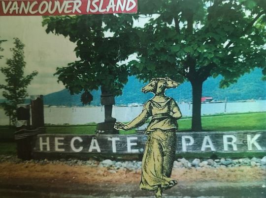
Image from Hecate Park & image of Hecate I made into a postcard.
I’ve grown up here on Vancouver Island. We moved here from Manitoba by the time I was 6 years old. It wasn’t til summer 2013 when I really became aware of the goddess Hecate (a story for another post!) and it was another few years before I clued into the connection between two local places I knew about, Hecate Park and Hecate Strait, with the goddess Hecate. I think the delay was due to the difference in pronunciation, the locales are pronounced Hek-et, and after hearing it my whole life, it just took me some time to connect the dots!
Hecate Island, image by Kira Hoffman
Since that time I have discovered there are 16 locales (as well as a fishing lodge and an inn) named Hecate on Vancouver Island and the surrounding areas! Obviously as a devotee of Hecate, I was thrilled to have this physical connection to a goddess associated with such faraway lands in history, and lands so different than the Pacific Northwest. But as so often happens, the actual story of how these places came to be named Hecate is neither terribly exciting, nor surprising really when the history of this island is looked at.
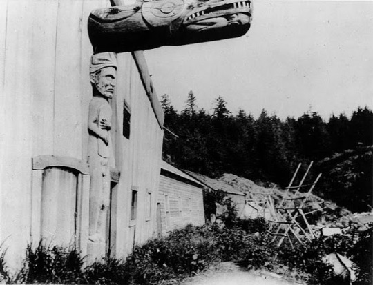
1903 Nootka House
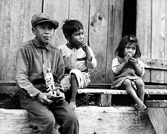
Kwakwakaʼwakw children in Yuquot (Friendly Cove)
Vancouver Island historically, and presently, is home to the Kwakwakaʼwakw, Nuu-chah-nulth and Coast Salish peoples. In the 1800s the British came and began their colonization of these lands as if they did not already belong to others. While this post isn’t about the atrocities that happened here, I would be remiss not to mention them. The repercussions are still being felt to this day. I recall being really surprised when I learned that a large proportion of Canadians actually knew almost nothing about the attempted genocide. Though it is now finally starting to be talked about in schools, the information being shared is not entirely accurate and still quite problematic according to a young Kwakwakaʼwakw woman I spoke with, whom has recently finished with the school system. I am grateful to my grandparents (an amazing couple whom I have much more to write about in another post) that raised me to be respectful of the land and the original inhabitants, and for always having been aware of what happened in this place. It has led me to feel a strangely conflicted feeling about living here. Feeling both so at home with this island’s spirit, yet always feeling a deep longing for Europe, and being but a guest here. I feel the same conflict about being thrilled to have locations named Hecate here while knowing how those locations came to be named.
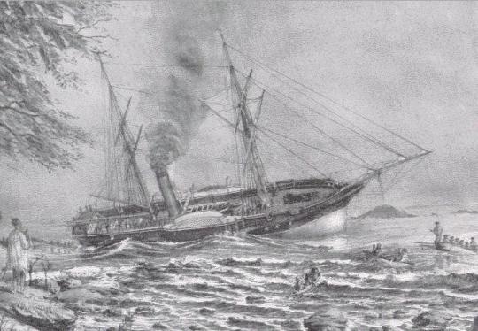
HMS Hecate aground in Neah Bay east of Cape Flattery between 15 and 21 August 1861
In 1860 Captain George Henry Richards first came to B.C. to do survey work on the H.M.S Plumper until she was decommissioned, he then continued the work aboard the H.M.S Hecate. And thus we see the origins of all these places being named Hecate. Captain Richards did survey work around Vancouver Island and the Sunshine Coast for two years. By all accounts he was a kind and fair man. Oftentimes he was called to break up disputes between the Indigenous people and whites, and he would invariably always call out the whites as being in the wrong. There are also stories of him giving treats and gifts to the Indigenous people and being generally very kind. I was personally very glad to read this. He also had some sweet mutton chops.
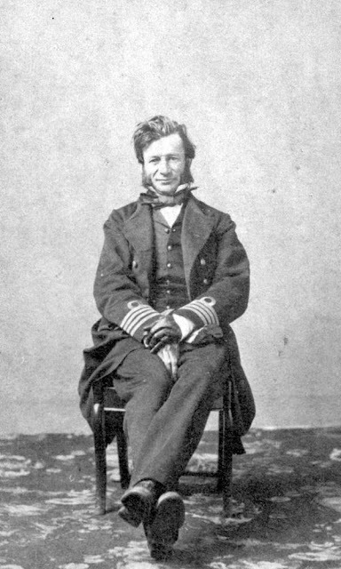
Captain George Henry Richards, Royal Navy, BC Archives
In naming places around coastal BC, apparently the indigenous names were kept as much as possible, but much that was not named already or if the indigenous name could not be used, then those places would be named. Many of the names given by Capt Richards were for his crew and even a favourite racehorse.
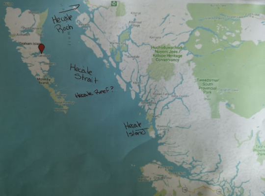
Here is the list I compiled of all the places named Hecate, on and around Vancouver Island, starting from the South and moving upward North Island and over to the Sunshine Coast.
Hecate Passage (E. of Chain Islets, W. of Plumper Passage)
Hecate Park (Cowichan Bay)
Hecate Street (Nanaimo)
Hecate Mountain (NE of junction of Uchucklesit Inlet and Alberni Inlet)
Hecate Bay (NW. of Meares Island, E. of Catface Range)
Hecate (abandoned locality NE side of Nootka Island)
Hecate Lake (N. end of Nootka Island, E. of Saltery Bay)
Hecate Channel (Between Zeballos and Tahsis Inlets)
Hecate 17 (East shore of Zeballos Arm of Esperanza Inlet)
Hecate Cove (N. side of Quatsino Sound, E. of Quatsino) [There is also the Hecate Cove Fishing Lodge]
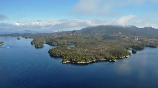
Hecate Island (Just N of Calvert Island)
Hecate Strait (Between Haida Gwaii & mainland) [On Haida Gwaii there is the Hecate Inn]
Hecate Rock (shoal in Duncan Bay)
Hecate Rock (Goletan Channel, Mount Waddington)
Hecate Reefs (I’m assuming this refers to the reefs in Hecate Strait)
Hecate Place (street in Vancouver)
According to British Columbia Coast Names by John, T. Walbran, Hecate Strait, Bay, Passage, Channel, Cove, Island, Rock (there are two in two different places) and reefs were named directly by Capt Richards between 1861-1862. The other places will likely have been named directly from those named by Richards.
{With libraries & archives being closed due to Covid 19 I wasn't able to access some of the information I'd originally gathered when I started this article several years back. That said, I think it contains most, if not all of the relevant information.}
While I was doing this research I realized there are quite a lot of places all over the world named Hecate, She certainly has made her way around the globe!
And lastly, I recently was also made aware of someone local who at one time had a boat named Hecate (retired), which if I get permission I will share a photo here of the boat herself, or at the very least, the beautiful wood sign with the name that was on the boat. They named the ship actually due to the goddess, the family having had a long time interest in Greek mythology.

Resources and references:
The private journal of Captain G.H. Richards: the Vancouver Island survey (1860-1862) (The first part is here: http://ronsdalepress.com/wp-content/uploads/2011/04/Private-Journal.pdf ) Ronsdale Press 2012
British Columbia Place Names G. P. V. Akrigg, Helen B. Akrigg, UBC Press 1997
British Columbia Coast Names 1592-1906 by John Walbran, J.J. Douglas Ltd 1977-2003
BC Geographical Names https://apps.gov.bc.ca/pub/bcgnws/
The Coast of British Columbia: Including the Juan de Fuca Strait, Puget Sound, Vancouver and Queen Charlotte Islands, United States. Hydrographic Office, U.S. Government Printing Office, 1891 - British Columbia
Dictionary Of Canadian Biography http://www.biographi.ca/en/bio/richards_george_henry_12E.html
Cobble Hill Historical Society https://cobblehillhistory.org/vignettes/item/26-hms-hecate
https://www.thecanadianencyclopedia.ca/en/article/vancouver-island#:~:text=The%20Treaty%20of%20Washington%20(1846,of%20British%20Columbia%20in%201871
Image Citations:
Nootka (Nuu-cha-nulth) House, 1903, Meany, Edmond S. (1862-19350 IN Meany Album v.2, p. 26, Digital Collection: American Indians of the Pacific Northwest Images, Edmond Meany Collection no. 132, Negative Number: NA 1150
Nuu-chah-nulth children at Friendly Cove, 1930s Alamy Stock Photo/Contributor Matteo Omied, Image ID 2BD7Y77
HMS Hecate - Public Domain
Captain George Henry Richards, Royal Navy; HMS Hecate and HMS Plumper, BC Archives, A-02432

3 notes
·
View notes

Photo
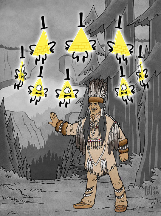
Bill and Modoc the Shaman
(click to embiggen)
Another piece to celebrate the anniversary of the release of the Blacklight Journal 3 Special Edition! This time, Modoc the Shaman! I was excited to see a drawing in the blacklight Journal 3 of Modoc, and had been wanting to do something with him ever since.
The reasoning and research behind the way he is dressed, along with illustrations, is probably best put under a cut...
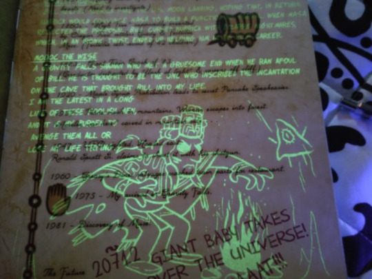
“Modoc the Wise. A Gravity Falls shaman who met a gruesome end when he ran afoul of Bill. He is thought to be the one who inscribed the incantation on the cave that brought Bill into my life. I am the latest in a long line of these foolish men, and it is my burden to avenge them all or lose my life trying.”
(Once again, indebted to @fordarkisthesuede for the pic of the blacklight Journal, and the transcription!)
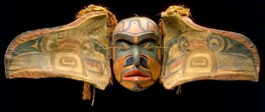
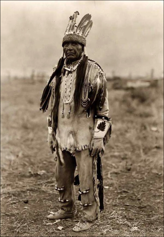
I really appreciated that the design for Modoc was clearly based on NW Coast elements, rather than his being a "generic shaman" design. The only problem, though, was that the headdress and robe he is wearing is pretty clearly identifiable -- the headdress is a Haida chief's design, featuring a carved frontlet and ermine surround, while the robe looks a little like a Haida robe and a little like a Tlingit chilkat robe (it's hard to tell at that angle and in just linework; but the Tlingit did trade with the Haida).

(Above, Haida Chief Son-I-Hat John McAllister, 2016)
So on the one hand, it's great that the design is from roughly the right part of North America! (Rather than being a Plains design, for example.) However, the Haida and Tlingit are coastal tribes, from quite far north (along the coast in what is now British Columbia in Canada, and southeastern Alaska). And, Gravity Falls, as shown on maps in the show itself, is not coastal, and is located in at least central to south Oregon. The tribes in that area aren't the same, and they don't have the same artistic and design expression.
(I'm not counting the presence of the totem pole in the show. So-called totem poles are also more of a NW Coast thing, but, in modern times, they've become a lot more widespread throughout the region. And the show is a case of a white guy using the totem pole as decoration for a tourist trap, in which case, it not being exactly geographically authentic is completely to be expected.)
So I decided to see if I could figure out how Modoc the Shaman might have looked, with a bit more of a nod to customs local to the Gravity Falls area.
The first issue, of course, is that while we have a general idea of where Gravity Falls is supposed to be, we don't have an exact location. It's *probably* in the Cascades in central-ish Oregon, but we don't know how far to the north or south. It's probably not as far south as Crater Lake, and it isn't as far north as Mt. Hood. Otherwise...? *Handwave*. This makes a difference because the tribe whose lands comprise the north-central Cascades are the Molala, while the southern Cascades (into northern CA) are the Klamath (including the area around Crater Lake).
In the end, I wound up going with a Klamath shaman design for Modoc, for a few reasons:
Edward Curtis took a bunch of photos of Klamath men and women, including one shaman, in the early 20th century. So it's easier to find references for Klamath ceremonial dress.
I wasn't having much luck finding good references for the Molalla.
the show named the shaman “Modoc”.
The Modoc tribe is from the same region as the Klamath, and is affiliated with the Klamath Tribes today.
I based this design of Modoc the Shaman specifically on photos of Lee Snipes, otherwise known as "Captain Sky", one of the last practicing shamans of the Klamath (according to their own tribal website). He was photographed in several outfits, and I blended elements from them. To figure out the coloring, I was able to hunt down a website with pictures from what seems to be some Smithsonian holdings of historical Klamath clothes and decorations, in color. (The problem with trying to reconstruct historical costumes from black and white photos, obviously, is that you can fall into the trap of making everything too monochrome. In this case, I felt a little more certain by the end that the outfit probably WAS fairly monochrome in earth tones, with some stand-out red and blue design elements, based on the historic clothing samples.)

(Above, my two main references. Both Lee Snipes / Captain Sky, taken by Curtis ca. 1923. Snipes was photographed in a variety of outfits. There are a few more photos of him, in which accessories vary but some basic design elements remain the same. It seems likely -- though I don’t know for sure -- that Snipes himself was selecting the outfits for the photos. I’m making an assumption, however, that these reflect what he would have worn for ceremonial purposes as a shaman.)
The other issue with figuring this out is that Modoc the Shaman is supposed to be from far in the past - 1000 CE. It's not ideal to be attributing what is essentially a modern design to a far-past historical figure -- that is, it's not great to suggest that a Native American tribe's ceremonial dress was static in design across centuries, when we know that almost all traditional designs evolve even if the culture is trying to keep to a tradition. So I just want to acknowledge that as problematic. Just because we know what a Klamath shaman was wearing in the early 20th century, we can't necessarily say that a shaman from the same region was wearing the same things 500 or 1000 years earlier. So, this is a good-faith effort to be more authentic to the region, but, with an acknowledgement of its limitations.
(At least we do know that the Klamath, or a form of that tribe, were living in the area for a very long time. When I visited Crater Lake, a ranger gave a presentation that included the fact that it's now been acknowledged by historians that Klamath oral tradition includes what are basically mythologized eyewitness accounts of the eruption that formed Crater Lake... 10,000 years ago.)
So there you go! This was an interesting exercise, and I like the results.
Finally, I should note: elements of this piece should be recognizable as a combination of screenshot-redraw modifications, most notably from The Last Mabelcorn. The background is also based on some screenshots.
384 notes
·
View notes
Photo
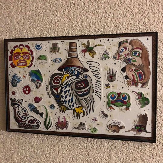
🌲🌲🌲 . . . Story time! This is a neo traditional style flash sheet inspired by two books that were read to me as a child: Echoes of the Elders and Spirits of the Cedar People by the great Chief Lelooska. Chief Lelooska was from the Kwakitul tribe so the stories in these books in particular are based off the Kwakitul history. But the books do include folklore from all the NW Coast Indians which include Tlingit, Haida, Nootka, Saitsh, Bella coola and Tsimshian tribes. The stories were told during long winter nights and taught children how to understand nature and other mysterious forces. . . . I am a white male with no known genealogy to any native American tribes. The extent of my background is only reading these stories as a child, attending a traditional Haida wedding in Alaska, and taking several classes at University my favorite of which was Ecosystem Science of PNW Indians. With these post I am just looking to share these beautiful stories with the utmost respect and give them some new energy as they have given me so much perspective and wisdom over the years. . . . #art #artistofinstagram #artist #pnwcoastindians #pnwcoast #oregon #washington #chieflelooska #echoesoftheelders #cedarpeople #indigenouspeoplesday #story #folktale #originstory #raven #sun #bear #seagull #box #traditionalbox #history #coastindians #goodnight #tattoostudent #freelanceartist #flash #neotraditionalflash #drawing #painting #watercolor (at Grants Pass, Oregon) https://www.instagram.com/p/CIQOz19LE14/?igshid=16q9mvbhr93lf
#art#artistofinstagram#artist#pnwcoastindians#pnwcoast#oregon#washington#chieflelooska#echoesoftheelders#cedarpeople#indigenouspeoplesday#story#folktale#originstory#raven#sun#bear#seagull#box#traditionalbox#history#coastindians#goodnight#tattoostudent#freelanceartist#flash#neotraditionalflash#drawing#painting#watercolor
0 notes
Link
BULLETIN Public Tsunami Message Number 1 NWS National Tsunami Warning Center Palmer AK 1235 AM AKST Tue Jan 23 2018 ...A TSUNAMI WARNING IS NOW IN EFFECT... ...A TSUNAMI WATCH IS NOW IN EFFECT... Tsunami Warning in Effect for; * BRITISH COLUMBIA, The Juan de Fuca Strait coast, the outer west coast of Vancouver Island, the central coast and northeast Vancouver Island, and the north coast and Haida Gwaii * SOUTHEAST ALASKA, The inner and outer coast from The BC/Alaska Border to Cape Fairweather, Alaska (80 miles SE of Yakutat) * SOUTH ALASKA AND THE ALASKA PENINSULA, Pacific coasts from Cape Fairweather, Alaska (80 miles SE of Yakutat) to Unimak Pass, Alaska (80 miles NE of Unalaska) * ALEUTIAN ISLANDS, Unimak Pass, Alaska (80 miles NE of Unalaska) to Attu, Alaska including the Pribilof Islands Tsunami Watch in Effect for; * CALIFORNIA, The coast from The Cal./Mexico Border to The Oregon/Cal. Border including San Francisco Bay * OREGON, The coast from The Oregon/Cal. Border to The Oregon/Wash. Border including the Columbia River estuary coast * WASHINGTON, Outer coast from the Oregon/Washington border to Slip Point, Columbia River estuary coast, and the Juan de Fuca Strait coast PRELIMINARY EARTHQUAKE PARAMETERS --------------------------------- * The following parameters are based on a rapid preliminary assessment and changes may occur. * Magnitude 8.0 * Origin Time 0032 AKST Jan 23 2018 0132 PST Jan 23 2018 0932 UTC Jan 23 2018 * Coordinates 56.0 North 149.2 West * Depth 12 miles * Location 175 miles SE of Kodiak City, Alaska 365 miles S of Anchorage, Alaska FORECASTS OF TSUNAMI ACTIVITY ----------------------------- * Tsunami activity is forecasted to start at the following locations at the specified times. FORECAST START SITE OF TSUNAMI ---- ---------- * Alaska Kodiak 0145 AKST Jan 23 Seward 0155 AKST Jan 23 Elfin Cove 0155 AKST Jan 23 Sitka 0200 AKST Jan 23 Yakutat 0205 AKST Jan 23 Valdez 0215 AKST Jan 23 Sand Point 0220 AKST Jan 23 Cordova 0225 AKST Jan 23 Unalaska 0240 AKST Jan 23 Homer 0255 AKST Jan 23 Craig 0300 AKST Jan 23 Cold Bay 0300 AKST Jan 23 Adak 0305 AKST Jan 23 Shemya 0350 AKST Jan 23 Saint Paul 0400 AKST Jan 23 * British Columbia Langara 0210 AKST Jan 23 Tofino 0340 AKST Jan 23 * Washington Neah Bay 0455 PST Jan 23 Long Beach 0500 PST Jan 23 Moclips 0500 PST Jan 23 Westport 0510 PST Jan 23 Port Angeles 0530 PST Jan 23 Port Townsend 0555 PST Jan 23 * Oregon Port Orford 0505 PST Jan 23 Charleston 0510 PST Jan 23 Seaside 0510 PST Jan 23 Newport 0515 PST Jan 23 Brookings 0515 PST Jan 23 * California Crescent City 0520 PST Jan 23 Horse Mountain 0525 PST Jan 23 Fort Bragg 0525 PST Jan 23 Monterey 0555 PST Jan 23 San Francisco 0620 PST Jan 23 Port San Luis 0620 PST Jan 23 Santa Barbara 0635 PST Jan 23 Los Angeles Harb 0650 PST Jan 23 Newport Beach 0700 PST Jan 23 La Jolla 0705 PST Jan 23 Oceanside 0705 PST Jan 23 OBSERVATIONS OF TSUNAMI ACTIVITY -------------------------------- * No tsunami observations are available to report. RECOMMENDED ACTIONS ------------------- Actions to protect human life and property will vary within tsunami warning areas. If you are in a tsunami warning area; * Evacuate inland or to higher ground above and beyond designated tsunami hazard zones or move to an upper floor of a multi-story building depending on your situation. * Move out of the water, off the beach, and away from harbors, marinas, breakwaters, bays and inlets. * Be alert to and follow instructions from your local emergency officials because they may have more detailed or specific information for your location. * If you feel a strong earthquake or extended ground rolling take immediate protective actions such as moving inland and/or uphill preferably by foot. * Boat operators, * Where time and conditions permit, move your boat out to sea to a depth of at least 180 feet. * If at sea avoid entering shallow water, harbors, marinas, bays, and inlets to avoid floating and submerged debris and strong currents. * Do not go to the shore to observe the tsunami. * Do not return to the coast until local emergency officials indicate it is safe to do so. If you are in a tsunami watch area; * Prepare to take action and stay alert for further information. IMPACTS ------- Impacts will vary at different locations in the warning areas. If you are in a tsunami warning area; * A tsunami with damaging waves and powerful currents is possible. * Repeated coastal flooding is possible as waves arrive onshore, move inland, and drain back into the ocean. * Strong and unusual waves, currents and inland flooding can drown or injure people and weaken or destroy structures on land and in water. * Water filled with floating or submerged debris that can injure or kill people and weaken or destroy buildings and bridges is possible. * Strong and unusual currents and waves in harbors, marinas, bays, and inlets may be especially destructive. * Some impacts may continue for many hours to days after arrival of the first wave. * The first wave may not be the largest so later waves may be larger. * Each wave may last 5 to 45 minutes as a wave encroaches and recedes. * Coasts facing all directions are threatened because the waves can wrap around islands and headlands and into bays. * Strong shaking or rolling of the ground indicates an earthquake has occurred and a tsunami may be imminent. * A rapidly receding or receded shoreline, unusual waves and sounds, and strong currents are signs of a tsunami. * The tsunami may appear as water moving rapidly out to sea, a gentle rising tide like flood with no breaking wave, as a series of breaking waves, or a frothy wall of water. ADDITIONAL INFORMATION AND NEXT UPDATE -------------------------------------- * Refer to the internet site tsunami.gov for more information. * Pacific coastal residents outside California, Oregon, Washington, British Columbia and Alaska should refer to the Pacific Tsunami Warning Center messages at tsunami.gov. * This message will be updated within 30 minutes.
#tsunami warning#tsunami#british columbia#washington state#oregon#california#hawaii#emergency#canada#united states
1 note
·
View note
Photo
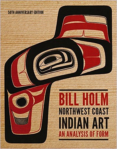
The Founding Textbook
This is the founding text of the modern revival of North NorthWest Coast indigenous art. The statements by a number of Northwest artists are wonderful; I was especially impressed with the statement by Robert Davidson, who I briefly met when I was on Haida Gwaii a couple of years ago. For anyone wanting to understand Northwest Indigenous art, this is the book. Holm has done invaluable work and, along with many Haida artists, this work, in graphics, jewelry, wood carving, and sculpture has become some of the most revered art in the world. I am, as a sociologist, also interested in the whole question of Cultural Appropriation and what it means in this context since the renewal and development of this art is based on work done by a Euro-American (Holm) and many indigenous artists, including Bill Reid, Joe David, Nathan Jackson, Robert Davidson and many others.
Go to Amazon
The NW Coast Formline "bible" - in color!
Wonderful to see this book in color. Long cherished as the NW Coast Formline "bible" by artists who design in this style.
Go to Amazon
An excellent classic
This is a really neat book. The images are high quality, the writing is above average and the them is interesting. It doesn't have the whole story, so you'll need to go see the real deal; however, it's an excellent jumping off point.
Go to Amazon
Great resource.
Nicely done art and graphics. Excellent source book.
Go to Amazon
Five Stars
Keep up the good work
Go to Amazon
1 note
·
View note
Photo
Just Pinned to Necklaces: Haida Indian Eagle Fine Silver Necklace - NW Coast Indian Key Ring - Haida Eagle Pendant - Fine Silver Salish Eagle Talisman - NW Coast Gift https://ift.tt/2PzV1sO
0 notes
Text
New Post has been published on Books What
New Post has been published on http://bookswhat.com/archives/44320
Totem Lost
Whereas Copper Spirit copes with the loss of life of her beloved father, his spirits seem to her. They inform her that to avoid wasting her individuals she should develop into a shaman. These apparitions set her on a deadly path that unfolds within the wilds of...
0 notes
Text
0 notes
Photo
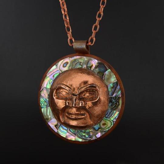
necklace, Mitch Adams (Haida, Tsimshian)
#mitch adams#haida#tsimshian#pendant#necklace#nw coast#abalone#shell#metalwork#copper#ndn#indigenous#native american#moon
92 notes
·
View notes
Photo
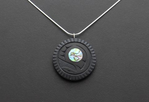
salmon egg pendant, Calvin Bell (Haida)
#calvin bell#haida#pendant#necklace#indigenous#argilite#abalone#shell#carving#nw coast#native american#ndn
110 notes
·
View notes
Photo

bear pendant, Calvin Bell (Haida)
#calvin bell#haida#indigenous#nw coast#pendant#necklace#bear#argilite#abalone#shell#carving#ndn#native american
118 notes
·
View notes
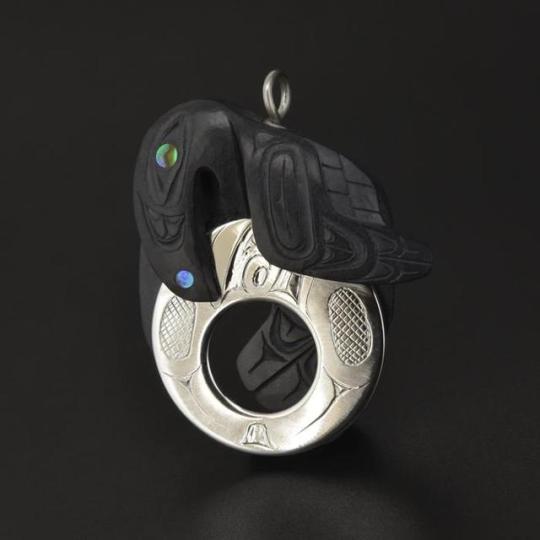
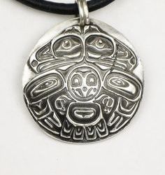
Photo
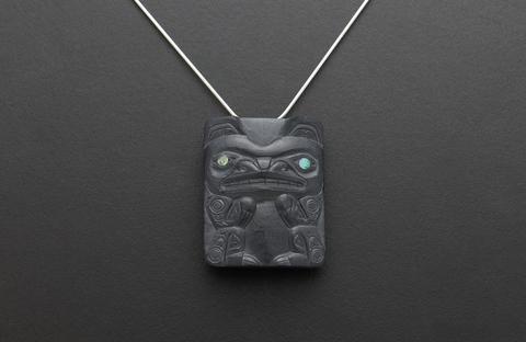
bear pendant, Andrew Williams (Haida)
66 notes
·
View notes
Last Seen Blogs

oliviaknittle
The 15 Stepping Stones for Coming of Age

muralofmymusings
Mural Of My Musings
morbidloren
Cemetery Postcards

listenhardtrainharder
#ListenHardTrainHarder