#maritime navigation
Photo

“ARE IN GREAT DANGER,” Daily British Whig (Kingston). December 18, 1911. Page 2.
----
A GRAVE CHARGE RE LAKE NAVIGATION.
---
Government Official Says Sailors Are Careless and Endanger Lives of Passengers.
----
Montreal, Dec. 16 - "The lives of thousands of passengers are being endangered yearly, not so much by defects in our navigation laws as because these laws are not enforced. I sometimes wonder how many passengers there would be on the great lakes and on our inland waters generally if only they had the least idea of the risks they run."
This was the statement made by Captain Charles Moller, compass adjuster and marine surveyor to the dominion government, in discussing the finding of the wreck commissioner recently relation to the stranding of the Canadian Lake Line's steam ship Coruna last summer.
In this particular case it was stated by officers of the vessel that the vessel went aground owing to the fact that while lying at a wharf in Montreal previous to the voyage on which she stranded, she was struck , by an outgoing steamer, the -impact destroying the accuracy of the compass.
Captain Moller stated that the.law required that a second compass be carried by all vessels. but that the law was not enforced. In his opinion owners in many cases would promptly supersede a captain who insisted on the extra expenditure. In cases where a second compass was carried it was generally stored away and never referred to, much less adjusted.
Lookout men, according to Captain Moller, are habitually careless and seldom make reports on lights or on other matters that do not seem to them to be of much importance.'
The reason, according to Captain Moller, that the law is not enforced, is that there are too few inspectors and consequently. the Canadian system is defective and compares most unfavorably with that of the United States.
Captain Holler intends going to Ottawa to lay the matter before the authorities.
#montreal#marine surveyor#shipwreck#maritime accident#ship's compass#lake navigation#maritime navigation#maritime journey#great lakes#shipping companies#capitalism in canada#history of crime and punishment in canada#crime and punishment in canada#government investigation
2 notes
·
View notes
Text
For instance, no one now disputes that when Europe's great age of maritime discovery was just beginning, Chinese navigation was far more advanced and Chinese sailors already knew the coasts of India, Arabia, East Africa, and perhaps Australia.*
*Some people think Chinese sailors even reached the Americas in the fifteenth century, but as I will try to show in Chapter 8, these claims are probably fanciful. The closest thing to evidence for these imaginary voyages is a map of the world exhibited in Beijing and London in 2006, purporting to be a 1763 copy of a Chinese original drawn in 1418. The map is not only wildly different from all genuine fifteenth-century Chinese maps but is also strikingly like eighteenth-century French world maps, down to details like showing California as an island. Most likely an eighteenth-century Chinese cartographer combined fifteenth-century maps with newly available French maps. The mapmaker probably had no intention of deceiving anyone, but twenty-first-century collectors, eager for sensational discoveries, have happily deceived themselves.
"Why the West Rules – For Now: The patterns of history and what they reveal about the future" - Ian Morris
#book quotes#why the west rules – for now#ian morris#nonfiction#maritime discovery#maritime navigation#maritime history#europe#china#india#arabia#east africa#australia#the americas#15th century#beijing#london#maps#world map#00s#2000s#21st century#60s#1760s#18th century#10s#1410s#cartography#california#deception
0 notes
Text
AIO's Maritime Legal Services: Safeguarding Your Assets and Maritime Operations
At AIO, our maritime legal services stand as a beacon of assurance for clients in the maritime, oil tanker and commercial vessel industry. With a comprehensive suite of services tailored to meet the diverse needs of our clients, we prioritise protection, compliance, and strategic counsel in every aspect of maritime law.
One of our core strengths lies in our Charterparty Expertise. Meticulously…

View On WordPress
#boats#bulk carriers#cargo ships#commercial vessels#container ships#cruise ships#ferries#fishing vessels#maritime#maritime accidents#maritime arbitration#maritime disputes#maritime economics#maritime environment#maritime industry#maritime infrastructure#maritime insurance#maritime law#maritime litigation.#maritime logistics#maritime navigation#maritime operations#maritime regulations#maritime safety#maritime security#maritime technology#maritime trade#maritime transport#naval vessels#oil tankers
0 notes
Text
The maritime codes of Italy /
translated and annotated by His Honour Judge Raikes.
Description
Tools
Cite thisExport citation fileMain AuthorRaikes, Francis William, 1842-1906.Language(s)English ; Italian PublishedLondon : E. Wilson, 1900.
SubjectsMaritime law > Maritime law / Italy.
NoteIncludes index.
Physical Descriptionxii, 264 p. ; 22 cm.
0 notes
Text
🚢 Light up your sea voyage and discover a new world! 💡⚓
✨ Marine floodlight - a must-have for sailing, lighting up the night sailing.
🌊 Waterproof design - Keep lighting stable in the face of waves, wind and rain.
🔍 Long illumination distance - illuminate the distance to ensure safe navigation.
🛳️ Ship equipment - suitable for all types of ships to help ensure safe navigation.
🌐 https://reurl.cc/lgznmE - Click to learn more and add sparkle to your sailing experience! #Marine Floodlight #Maritime Navigation #Navigation Lighting
#street lights#floodlights#Navigation Lighting#Maritime Navigation#Marine Floodlight#led lights#Floodlight for Marine Use#Marine Searchlight#Ship Floodlight#Nautical Spotlight
0 notes
Text
I am always deeply in love with a man that loves to run experiments.
"A year later, in September 1839, Ross took command of HMS Terror and Erebus and commenced a four-year expedition to the Antarctic. Ross and Terror's captain, Francis Crozier, performed magnetic experiments as they sailed down the Atlantic and across the Indian Ocean, setting up magnetic observatories at St Helena, Cape Town and Hobart. These would, initially, be sites of scientific activity quite distinct from existing colonial astronomical observatories but, within a few years, the Cape's magnetic and astronomical observatories would merge together into a single research institution. Although disappointed to find that the South Magnetic Pole was far inland, Ross went on to determine its approximate location in 1841 and returned to Britain in 1843 with a wealth of magnetic data."
#Francis Crozier#james clark ross#British Magnetic Scheme#Magnetic Crusade#maritime history#magnetic readings#naval history#naval navigation#age of sail#Mo chuisle
34 notes
·
View notes
Text

I FUCKING LOVE LIGHTHOUSES!!!!!!!!!!!!!
11 notes
·
View notes
Text

Johann Michael Vogler, Universal equinoctial dial for latitudes 0°-90° North, early 18th century. Brass. Ellingen, Germany. Via National Maritime Museum, Greenwich.
#Johann Michael Vogler#equinoctial dial#National Maritime Museum#sailing#antique maritime#sailboat#navigation#antique navigation#history#artifact#historic
168 notes
·
View notes
Text
youtube
13 notes
·
View notes
Text

For the night is dark and full of terrors
#life at sea#maritime#merchant marine#nautical#ocean#sailing#boats#cargo ship#navigation#helmsman#el mar#barcos#sail
4 notes
·
View notes
Photo
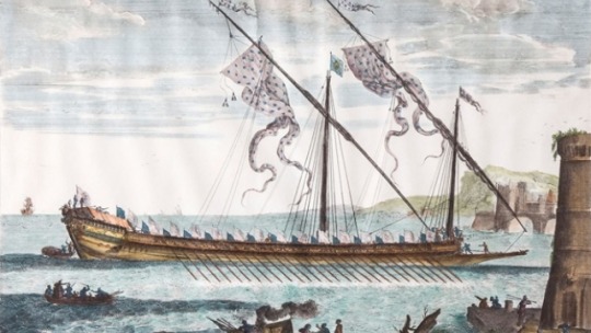
27 septembre 1748 : ordonnance de Louis XV abolissant l’institution des galères ➽ https://bit.ly/2MPS59d On avait fini par trouver que ce genre de bâtiments, en usage pendant l’enfance de la navigation, était incommode dans ses distributions, fort coûteux, de ressource presque nulle pour la guerre
#CeJourLà#27Septembre#Abolition#Galères#Mer#Maritime#Navigation#Guerre#Institution#Ordonnance#Roi#LouisXV#histoire#france#history#passé#past#français#french#news#événement#newsfromthepast
2 notes
·
View notes
Video
youtube
#156 Colreg card. Ship's navigation daytime shapes and action to avoid c...
#youtube#colreg#colregs#navigation#education#sea#marine#maritime#seafarer#seaman#mariners#rules#ror#ship art#vessel
0 notes
Text
youtube
#youtube#usmilitary#Navigation Safety#Key Bridge#Baltimore#Temporary Channel#Port of Baltimore#Bridge Navigation#Patapsco River#Carmen Ship#Vessel Traffic#Maryland#Shipping Channel#Navigates#Key Highway Bridge#Incident#Bridge Collision#Maritime#Shipping News#Shipping#Ship Operations#Maritime Incident
0 notes
Text

1 note
·
View note
Text
1 note
·
View note
Text
What is Sextant?
In the past, people would hold a sextant in their hands to determine the angle that the horizon formed with respect to the sun, moon, or stars. Prior to the development of contemporary navigation systems such as GPS, it was a crucial instrument for ships to determine their latitude and chart their voyage over the seas.
An eyepiece, horizon glass, and a moveable arm make up the sextant. The user would use the movable arm to align the image of the celestial object with the horizon after sighting it through the horizon glass. The instrument's scale may then be used to read the object's angle with respect to the horizon.
With this angle measured and the time in hand, navigators could use celestial navigation methods and tables provided in books to determine their latitude. Even in the middle of the enormous oceans, before satellite navigation became accessible, sextants allowed sailors to precisely map their position and route by measuring the ship's speed and direction.
Although sextants are no longer used for marine navigation, they are still employed for some specialized tasks such as surveying, astronomy, and training in celestial navigation. During the Age of Sail and Discovery, they allowed for precise transoceanic sailing and exploration, which is a significant historical accomplishment.
#sextant#marine#navigation#maritime#CelestialNavigation#MaritimeHistory#AgeOfExploration#AgeOfSail#Navigation#NavalInstruments#NauticalAntiques#Seafaring#VintageNavigation#SextantNavigator#ClassicInstruments#NavigationTools#NauticalEquipment#TraditionalNavigation
1 note
·
View note
Last Seen Blogs

v-for-void
expletives and series of incomprehensible horrors

katyswritingjournal
Katy's Writing Journal

littlemiss-anonymous-blog
little miss anonymous

iconssworld
☆•Kpop Icons•☆
aiiidoneus
aidoneus