#sub-alpine fir
Text


Carcross Desert, YT (No. 2)
Carcross Desert is significantly drier than the surrounding region, receiving less than 50 cm (20 in) of precipitation per year. This is due in part to a rain shadow effect caused by surrounding mountains. As a result, several rare species of plant life have taken hold in the comparatively arid conditions. Carex sabulosa, the Baikal sedge, is only known to exist in four other sites in North America, mainly existing in Asia. Yukon lupine, also unusual for the surroundings, "grows like a weed." While the vegetation in the area currently locks much of the dune system in place, a large event such as a forest fire could easily clear out the vegetation and return the dunes to an active state.
Source: Wikipedia
#Caribou Mountain#Nares Mountain#Carcross Desert#travel#original photography#vacation#tourist attraction#landmark#landscape#northern sand dunes#sand#tree#sub-alpine fir#woods#forest#floran#nature#countryside#cityscape#Carcross#Yukon#the North#Canada#summer 2023#world's smallest desert#snow
22 notes
·
View notes
Text
youtube
So, with the school holidays approaching fast, we have been looking out for family friendly breaks to keep the kids entertained.
Trabolgan Holiday Village is well known for its magical surroundings, excellent facilities and range of indoor & outdoor activities.
Trabolgan is not only a great holiday destination, it has also established itself as one of Irelands most popular Day-Trip destinations for families, school tours, corporate outings and has a variety of activities to choose from . It is located in an idyllic and tranquil setting beside the sea near Midleton in East Cork.
There are an incredible range of activities to choose from at Trabolgan. Families can try out Trabolgan Adventure Sports, which include an incredible BRAND NEW High Ropes Course, combat laser, abseiling, go karting, zip-wiring, climbing, bungee trampolines, archery, footgolf, to name a few . Of course, no trip to Trabolgan Holiday Village is complete without a visit to the indoor sub – tropical swimming pool complex with panoramic views of the Atlantic and the infamous wave machine! In addition to that there are incredible nature walks as well as access to the newly opened beach.
Phone: +353 (0) 21 4661551 or Email: [email protected]
Family Self Catering Holiday Homes At Trabolgan Holiday Village

They can offer a range of holiday homes from intimate one-bedroomed houses right up to our largest homes that can accommodate up to nine people, meaning we can find something that’s right for you, no matter how small or large your family or group are.
Unfortunately no pets are allowed, with the exception of guide or assistant dogs.
Alpine Self Catering Cottages - ideal for up to two/three people
Chestnut Self Catering Apartments & 2 Storey Holiday Homes - ideal for up to five people
Forest Oak Self Catering Houses - ideal for six/ seven people
Sycamore Self Catering Houses -ideal for up to six people
Hazel: Large Holiday Lodges - ideal for up to eight people
Noble Fir: Detached Self Catering Holiday Homes - ideal for up to nine people

0 notes
Note
so, in the kingdom of anthea, there's a light province, a water province, a nature province, an ice province, a fire province, a metal province, a healing province, an earth province, a sky province, a wood province, and the capital :o could you tell us a bit about each province and which characters are from where? :)
Right off the bat I just want to make something clear: The people of a province generally won’t have the same magic as their rulers, even if it’s something valued by them the vast majority of people will just pick literally whatever they want, aside from the heirs who have to learn that type of magic. I just want to make that clear because I’ll be referring to them as “the XYZ province” and those are just placeholder names! I’m having a hard time finding real names since I feel like I should have a “theme” just like I did with the plant names for each character but it’s surprisingly harder than I thought :p each province takes light influence from certain parts of the world but that’s mostly in the people being represented to have a connection to the real world and I don’t plan to dive too deep into fantasy culture and history beyond what’s needed as far as lore goes, I’m not Tolkien lol, but any an all input is still welcome on it! anyway, I’ll put all the rest under the cut so I clog people’s dashes.
Well, before I even start here’s a map of Anthea! labeled (Still with the placeholder names) and color coded :) this’ll just be good for reference, so I’ll start in the middle with the light province and go around in a loop! As for which characters are from where I should probably make a separate post for that since this one’s already going to be long and wordy, for the most part though most H.A. students that aren’t heirs are from the light province (or were born their with their parents being from somewhere else) since that’s where the school is, the heirs are just super rich kids that get to go abroad lol
First off is the central light province ruled by Angrec, after taking over from the now deceased Ambrosia, with Amaryllis being the current heiress. Since it’s the central province and the ruler of it is also the ruler of Anthea as a whole. It used to be the only one before it became impossible to manage by single people, as opposed to Iris and Crocus before Iris stepped down and passed it off to Anne-Lace, the first queen, who started to break it off into pieces governed by sub-rulers like dukes and duchesses to make it more manageable. The province itself is filled with big cities as well as tiny villages, it’s a huge melting pot of people from all around Anthea. The main influence was the United States but with European-eque villages. For example the way I view the village that Hecate Academy is in is very heavily influenced by my own home village of Karpenisi in terms of lay-out, basically just taking inspiration from my own childhood experiences in both Greece and America.
Then is the sky province, ruled by Weigela who has recently taken after her father fell ill and passed away, leaving her younger sister Wedelia as the heir apparent. The province is mainly inspired by countries in the Mediterranean region, mostly Greece since like I said before it’s a place I’m more than familiar with! It’s a mountainous alpine province with buildings and houses built around and going up the mountains. It also has lots of temples and ruins, because is the most devout to Iris of all, hence their abundance of temples, but they used to have the same energy for Crocus, that’s where the ruins come from. They’re not as celebrated.
Next is the ice province, as you can probably guess it has an icy arctic terrain and is located high up north. It has cities and villages with buildings made of ice, full of beautiful crystal-like structures and cities. It’s real-world inspiration is twofold, with both Russian and Inuit influence, though the latter is heavier depending on the part of the province. It’s also known for its beautiful northern lights, they’re said to be enchanted in a wish-upon-a-star type way, though that’s largely considered to just be a cute story to tell to kids.
After that is the wood province, currently ruled by the youngest heir in its history by a longshot, Elm at age 13 took over after his mother’s death, but he also has a team of advisers that guide him through a lot of the process since he was mostly unready to take over so soon, and he wouldn’t have had to if he were just two months younger. The province itself has influence from Asian countries with the heaviest probably being Japanese. The environment is a contrast between small farming villages with wooden homes and huge neon cities and the province is big in technological innovation, especially in terms of crystal technology, being the place where crystal screens (Anthea’s smartphone equivalent) were invented.
Right underneath it is the fire province, ruled by Calendula with her second child Celosia as the heir apparent, after her first child Ash quit. The province’s influence is also from Asian countries but with a much heavier influence from India as well as bit of the Middle East. The two provinces actually share one island together where one gradually shifts into the other. Of course it is ruled by fire so expect hot weather and a focus on fire throughout. Buildings vary from small and humble to castle-like depending on the area, and it’s not uncommon to find temples scattered throughout.
After that it’s the earth province, it’s current ruler is Sycamore and her three children, Senna, Maple, and Morel, are the heirs. It’s the largest one so it also has the largest range in culture going from small villages that live closely knight, to huge buzzing cities with unique architecture. Generally both actively try to avoid harming the earth, since it IS the earth province, that’s something important. Unsurprisingly it also has a lot of mountains including the largest in Anthea, it’s so large that it’s seemingly impossible to climb, no one ever has, and people say it’s cursed to be that way.
Then is the healing province, the landscape is generally very hot and dry, desert-like in some places, but filled with beautiful and lively villages. It’s a province that values and celebrates life, as the healing would imply, and the people are generally regarded for being super hospitable. It’s influence is Central American and it’s currently the smallest province. The current sitting ruler is Vervain, who currently has no children and instead of passing it off to the closest blood relative plans to choose her own heir.
Next is the nature province, it’s current rulers are Mullein and Fir, and their daughters, Chrysanthemum, Magnolia, and Celandine, are the heirs. It’s a very large providence filled with flora, it’s main influence is South America and it’s probably the province that sticks to it’s own aesthetic the harshest. Tree-house villages are incredibly common in it’s vast forest areas, and other villages will be big valleys filled with flowers, cities won’t keep up this aesthetic as harshly but aspects of it will still be there. Generally it’s regarded as the most mellow and peaceful province.
Right by that to that is the metal province, based on Western Europe with the heaviest influence from England. The province is incredibly industrial with a combination of huge factories and metalworks along with castles and medieval aesthetics, it’s going through a bit of a shift between the old and new ways, becoming kind of steampunk in aesthetic (but no actual steam or this would have been the steam province). It’s current ruler is Ironwood and his daughter Clarkia is both the heiress as well as a local knightly hero.
And lastly in the middle of the ocean, of course, is the water province. It takes influence from both Hawaii and… Myths about Atlantis, making it the only one not influenced by reality, but after all this is a fantasy story. The Atlantis influence is obvious, because the vast majority of the province is actually completely underwater. The people cannot breathe underwater, it’s under a magic dome, and the only way in and out is on the surface areas of the province. There are many tropical villages on top of islands too, but underwater it’s filled with huge villages and cities and cities and incredible sights you can only get underwater. It’s current rulers are Dehlila and Kelp, and their heirs are their two kids, Geranium and Coral.
There’s actually another landmass too. It’s not a part of Anthea though, it’s not a part of anything. This island used to be Crocus’ personal playplace. Iris cast it aside from Anthea in order to protect people from her brother’s monsters. It’s also known as the Forbidden Island, it stands as lonely as can be far away from Anthea. It’s landscape is bleak, beran, filled with monsters, curses, and chaos. Though there are also ruins there from long-forgotten villages and homes before the people were forced out.
#finn's ocs#i answered this late and i finally got motivated to finish it sorry :p#its 5:30 so im sorry if it gets sloppy in some places but hopefully im legible#its kind of long though! and can drag on in some places....#its Good Enough for now#pakbet#Answered#in all honestly i havent really put a lot of time into coming up w names anyway. i was just always like#''eh i have placeholders ill do it later lol''#i should. actually sit down and do it
17 notes
·
View notes
Photo
The Rocky Mountain Subalpine Fir Tree is one of the essential parts of the ecosystem in the Rockies, according to the US Forest Service, the tree is highly sensitive to fire, and even low-intensity fires prove fatal for all but the healthiest trees. The last major fire in the park was the 2012 Fern Lake Fire, which was caused by an illegal campfire and burned for two months, causing firefighters from around the world to be called in for support.
MORE LANDSCAPES HERE
INSTAGRAM
The sub-alpine fir provides good environmental protection for elk, moose, mule deer, small mammals, and birds in Colorado. It also has a high potential for erosion control in Colorado. Conversely, the sub-alpine fir provides good environmental protection for elk, moose, mule deer, small mammals, and birds in Colorado. It also has a high potential for erosion control in Colorado.
Inspiration: Ring of Fire - Johnny Cash
Taken: Rocky Mountain National Park, 12-15-19 943AM
Nikon D7200, 200-500mm f/5.6
#monochrome#black and white#rocky mountain national park#rmnp#national parks#winter#colorado#snow#black#white#lines#abstract#trees#subalpine fir#mountains#art#fine art#landscape#landscape photography#nature#nature photography#natgeo#nikon
5 notes
·
View notes
Text
Heaven on Earth: Annapurna Base camp Trek
Heaven on Earth: Annapurna Base camp Trek
Annapurna Base camp Trek though one of the most scenic routes in the world, a visit to the Annapurna Base camp will have you traverse through dense forests and beautiful landscapes, with the pristine Himalayas never out of sight. The highlight of the trek to ABC trek (Annapurna Region ) poon hill viewpoint is the best sport to see mountain views. where you can, on a clear day, view all peaks of the Annapurna, Dhaulagiri, and Manaslu Range on a clear day. Surrounded by verdant forests on all sides, Poon Hill is a popular destination for local and foreign tourists alike. Especially famous as a short trek destination, Ghorepani-Poon Hill pulls in a crowd of up to 1000 tourists every day during the peak seasons.
This season though, Poon Hill hardly welcomed 400-500 visitors each day. The recent devastating earthquakes, the Indian blockade and the unrest in the Terai have affected this world-renowned destination of tourists. The mountains still exude the same serenity and are still calming and imposing. “The natural beauty has not changed, and the hotels are ready to serve the guests,” a local entrepreneur said on a recent visit, “But there are hardly any tourists.” Ghandruk, Ghorepani Poon Hill await visitors. Annapurna Circuit Trek joined place Ghorepani.
The Annapurna Base Camp trek lying at the foot of the Annapurna massif is reached after traversing through a rapidly changing landscape as you climb higher and higher from the rich green valley shrouded in seasonal vegetation to the arid landscape of the high mountains. The Annapurna Sanctuary is a gigantic amphitheater facing giant peaks at close proximity. 4,130 m above sea level, the sanctuary enjoys a spectacular 360 view of 13 peaks that make up the Annapurna massif. This obviously is the highlight of the trek. But even from Day One of the treks, the great peaks, Machapuchare (6,993m), the Annapurna III (7,555m), the Annapurna II (7,937m) and the Annapurna IV (7,525m) keep coming into view, building up excitement as the trek progresses.
Along the way are the hot springs at Jhinu Danda, delightful little Gurung villages embraced by terraced hillsides, hidden trails in the heart of a gigantic bamboo plantation, and a forest of rhododendrons. This trek offers all the pleasures one can derive from a walk in the Nepalese Himalaya. If you want an adventure trekking trail Manaslu Trek package here.
Why Annapurna Base Camp is among the most popular treks in the world
The Annapurna base camp trek is one of the most popular treks in the world. It literally brings you face to face with an eight-thousand – for a moderate-difficult trek, this is incredible! The fascinating Annapurna massif includes the world’s tenth highest peak. Annapurna I (8,091 m) holds an almost fatal attraction for mountaineers. It has the highest fatality ratio among the eight-thousanders. This formidable aura apart, the ABC trek holds several treasures for the mountain lover.
How difficult is the Annapurna Base Camp trek?
We rate the Annapurna Base Camp trek as “Moderate-Difficult.” There are two major reasons the ABC trek is considered Moderate-Difficult. First, the distance. The trekker covers a total distance of 90 km over 14 days of the trek. This includes three days where you cover more than 10 km, with the longest being 15.5 km from ABC to Bamboo.
Is Annapurna Base Camp trek safe?
The Annapurna Base Camp trek has a buffer day included in the itinerary. This ensures that we have a day more to complete the trek in case of unfavorable weather. Besides this, the Well plan Trekking trek team for a full strength batch comprises a Trek Leader, Guide. The team is equipped with an oximeter, blood pressure monitor, and a high-altitude medical (HAM) kit. The Trek Leader maintains a health card with a record of every trekker’s vitals (Blood pressure and oximeter readings) taken twice a day. Training properly for the trek for at least a month, hydrating yourself during the trek will also ensure you complete the trek safely and in a good condition.
Trekking inside the forests of the Annapurna Conservation Area
The trek is nestled in the 7,629 sq km Annapurna Conservation Area. This is home to 1,226 species of flowering plants, 102 mammals, 474 birds, 33 reptiles and 22 amphibians. If you’re lucky you might spot an exotic bird or even a marmot. While trekking from Ghandruk to Chomrung you are surrounded by rhododendron, fern and bamboo. Once you cross Sinuwa to enter the Annapurna sanctuary, the forest becomes dense. Tall oak trees become prominent here. As you move higher up towards Deurali, the thick forests give way to tall grass. Around this area, you will find trees with thick bark called Daphne. This is used by locals to make paper. These trees are commonly found around Sandakphu as well. Closer to Machapuchare base camp, the terrain turns Alpine. You see patches of grass amidst boulders. There are also flowering plants lining the trail in this section. The trail has 3 sections through the forest that is so dense that sunlight barely seeps through. The first one starts right after the villages around Chomrung and extends till New Bridge. On the trail from Sinuwa, you hear the Modi Khola roaring past right next to you. But the trees around are so dense that you can’t really see the river. The third stretch is after Bamboo and goes all the way to Dovan. The beauty of this trek is that you walk through these forests not once, but twice!
DETAILS ITINERARY
Day 01: Arrive in Kathmandu 1,345 m and then transfer to respective Hotels
On reaching Kathmandu via respective airlines well received by company guides and staff for a short drive in the hub of Kathmandu city where your hotels located. After checking into your lovely rooms getting refreshed join in at the Hotel lobby for a group briefing regarding treks and other useful information to make your stay in Nepal enjoyable and pleasant.
Day 02: Drive to Pokhara 860 m – 06 hrs journeys (via flights 30 mins on air).
Annapurna Base Camp trekking begins with the overland drive to Nepal Mid West taking a comfortable coach or in Tourist Bus to reach scenic Pokhara, a beautiful and leading touristic place in all Himalaya range, with warm sub-tropical temperatures and close views of Annapurna Himalaya with Mt. Machhapuchare ‘Fish Tail’.On reaching Pokhara transfer to respective hotels by the Phewa Lake with views of Annapurna and Machhapuchare peak, afternoon at leisure for short walks around the lakeside. Meals included: Breakfast
Day 03: Drive beyond Nayapul and trek to Ulleri village 1,740 m – 06 hrs.
Morning departs from the hotel taking a short drive where the journey takes you beyond Pokhara, valley-facing views of Manaslu and Annapurna Himalaya. On reaching at Nayapul following Modi River to Bhirethati village from here drive leads further past farm villages and terraced fields to reach at Hille on the foothills of Annapurna, where our first-day walk begins heading for high hills on stone steps to reach at the nice and lovely village at Ulleri with views of Annapurna peaks. From this small farm village, our first-day walk starts heading north with the steep climb on the stone-paved steps to Jhinu village located on a high scenic ridge, from this village a short walk downhill leads you to natural hot-spring by the Modi River. Meals included: Breakfast, Lunch, Dinner
Day 04: Trek to Ghorepani village 2,845 m – 04 hrs.
The morning begins heading uphill to reach a ridge above Ulleri and Bhanthati villages, as the walk continues on the gradual winding path into the deep forest covered with tall rhododendron-magnolia-
pine-oak and fir trees. Slowly walk climbs higher side of the mid-hills to reach at charming Ghorepani village with blue painted houses serving as lodges for trekkers offering marvelous views of the Dhaulagiri range of peaks with Annapurna Mountain. Ghorepani situated on the old Trans-Himalayan Salt Trade Route of Nepal and Tibet where the route leads past towards Upper Mustang to Tibet Border called Karo-la. A wonderful spot in the midst of tall rhododendron trees, in spring the whole hills turn to magic when rhododendron flowers are in full blooms of different colors. Meals included: Breakfast, Lunch, Dinner
Day 05: Hike to Pun Hill and continue walking to Tadapani 2,680 m -06 hrs
Early morning hike for an hour or more uphill to Pun Hill on the highest spot of the adventure at above 3,210 m high offering striking sunrise views over a panorama of peaks that includes Dhaulagiri-Tukuche-Nilgiris-Annapurna and Manaslu range of mountains with majestic Machhapuchare Himal ‘Fish Tail peak’.Enjoying breathtaking super views of mountains with sunrise head back to Ghorepani for breakfast and continue trek heading uphill into rhododendron forest with fantastic views of peaks and then downhill with the last climb to reach Tadapani, located in the midst of a forest with superb views. Meals included: Breakfast, Lunch, Dinner
Day 06: Trek to Chhomrong 2,020 m -06 hrs
Leaving Tadapani, our trail descends to Kimrong river through the jungle of rhododendron. We then hike to Chhomrong going across the Gurung village. Chhomrong will bestow you close scenery of Mt. Annapurna south, Himchuli and Fishtail (Machhapuchhre). Tonight at Chhomrung. Meals included: Breakfast, Lunch, Dinner
Day 07: Trek to Dovan 2610 m -06 hrs
Today, we set off from Chhomrong and descend to Chhomrong stream and then make our way up to Dovan. On the way, we will be passing through amazing rhododendron woods. Overnight at the guest house in Dovan.Meals included: Breakfast, Lunch, Dinner
Day 08: Trek to Deurali 3200 m -06 hrs
Today, we climb to Deurali through the rhododendron and bamboo forest. The place located on the ridge of Hinko Cave and it is the trail most stretch subject to avalanche. Meals included: Breakfast, Lunch, Dinner
Day 09: Trek to Annapurna base camp 4,131 m -06 hrs
We begin trekking up to Machhapuchhre base camp (3900m.) and then proceed to Annapurna base camp. The area is encircled by the peaks and is recognized as Annapurna Sanctuary. This set gives you an impressive view of huge peaks including Annapurna I, Barah Shikhar, Annapurna South, and many other giant peaks. Meals included: Breakfast, Lunch, Dinner
Day 10: From Annapurna Base Camp walk downhill to Bamboo 2,345 m – 06 hrs.
After a great fascinating time at Annapurna Base Camp and within a beautiful sanctuary, a long walk downhill to lower areas as the morning leads to a descend to Deurali past Machhapuchare Base Camp, then with few short ups and down following a gradual winding trail back into the green forested area to Bamboo for the overnight stay. A nice and pleasant spot a temporary settlement with lodges to cater to the needs of the trekkers located by the Modi River in a gorge within green bamboo and rhododendron forest. Meals included: Breakfast, Lunch, Dinner
Day 11: Trek to Jhinu village 1,780m with Hot Spring – 06 hrs.
From Bamboo a short steep climb up to Khuldi Ghar, then on a winding downhill path into the dense forest to Sinuwa-Danda, and then our walk descends to Chomrong Khola. After crossing the bridge an uphill walk for less than an hour to reach at Chomrong village for short rest or lunch stop, after Chomrong a short up for half-hour reaching at the top of Chomrong ridge, from here our route descends to Jhinu-Danda for an overnight stay, this place offers refreshing hot springs just 20 minutes’ walk downhill near Modi river. Meals included: Breakfast, Lunch, Dinner
Day 12: Trek to siwai and drive back to Pokhara
Eventually, it is our last day of trekking. We are walking sawai for 2 hours then return driving back to Pokhara. Meals included: Breakfast
Day 15: From Pokhara drive to Kathmandu 1,345 m – 06hrs.
After a wonderful time in the high mountains and hills, taking a morning driving journey back to Kathmandu, on reaching Kathmandu after 5-6 hours of nice interesting drive, transfer to respective hotels with the afternoon free at leisure or last day shopping souvenirs and handicrafts. Meals included: Breakfast
(Options by air 30 minutes flight back to Kathmandu with great views)
Day 16: International Departure for Homeward Bound.
Last day in Nepal in the country of high Himalayan mountains with fascinating culture, after a memorable time on Annapurna Base Camp Trekking with wonderful adventure and experience, as per your international flight time our staff transfers you to the airport for the flight homeward bound or to your next port of call and respective countries. Meals included: Breakfast
0 notes
Photo

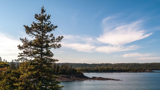
Best Things To Do in Acadia National Park
Best Things To Do in Acadia National Park: Acadia National Park protects the natural beauty of the highest rocky headlands along America's Atlantic coastline. This 47,000-acre recreation area -- primarily on Maine's Mount Desert Island -- features woodland, rocky beaches and glacier-scoured granite peaks such as Cadillac Mountain, the highest point on the United States' East Coast. Among the wildlife are moose, bear, whales and seabirds. The bayside town of Bar Harbor, with restaurants and shops, is a popular gateway. And each year, more than 3.5 million people explore seven peaks above 1,000 feet, 158 miles of hiking trails, and 45 miles of carriage roads with 16 stone bridges. My name is Rob Decker and I'm a photographer and graphic artist with a single great passion for America's National Parks! I've been to 51 of our 63 National Parks — and Acadia is great park the whole family can enjoy! I have explored most areas of the park — so I'm ready to help! So if this is your first time to the park, or your returning after many years, here are some of the best things to do in Acadia National Park! Explore Mount Desert Island The majority of Acadia National Park is located on Mount Desert Island. The island offers an endless array of activities for everyone including a visit to Sand Beach, Thunder Hole and Otter Cliff. Here, the mountains truly meet the sea and you can enjoy one of the most spectacular settings on the entire East Coast. With its beautiful coastal scenery, the island is a great location for hiking or ocean kayaking. Bar Harbor, the largest town on Mount Desert Island is often thought of as synonymous with the Park. But visitors can also stay in charming Northeast Harbor, Southwest Harbor, Bass Harbor, Otter Creek, Seal Harbor or Somesville. Drive the Park Loop Road The 27-mile Park Loop Road is the best way to navigate through Acadia National Park. The loop begins near the Hulls Cove Visitor Center on the north side of the island in Bar Harbor. It connects the park's lakes, mountains, forests and rocky shores -- making exploration easy. Sand Beach, Thunder Hole and Otter Cliff and other popular sites and trails can be reached from the road. 20 miles of the Park Loop Road is one way. But there is a two way section that begins near Wildwood Stables -- perfect for taking in the magnificent views. Hike, Bike & Ride the Carriage Roads This 57-mile long network of paved paths created and financed by John D. Rockefeller Jr. provides hikers, bikers, inline skaters, horse riders, and horse-drawn carriages a unique way to visit Acadia National Park. Over the course of the 27-year project, Rockefeller designed the paths to highlight the best scenery in the park -- circling around Jordan Pond, Eagle Lake and Mount Desert Island. The Carriage Roads are off-limits to motor vehicles. During the winter months, some of these allow for cross-country skiing and limited snowmobiling. Explore Jordan Pond When you think of the most idyllic spot in Acadia National Park, Jordan Pond with its pristine calm waters surrounded by lush, majestic mountains in all directions usually comes to mind. The Jordan Pond Nature Trail -- an easy stroll through the evergreens -- and the Jordan Pond Shore Trail -- a more difficult trek along the rocky coast -- spill out to the picturesque and pleasant respite of Jordan Pond. Regardless of your route, at the end you'll find crystal-clear waters that mirror the surrounding mountains. Swimming is not allowed, but non-motorized boats such as canoes and kayaks are permitted. Hike Cadillac Mountain Cadillac Mountain -- at 1530 feet -- is not only is it the tallest mountain in the park, but it's the tallest mountain on the North Atlantic seaboard. It's also the first point of the United States to greet the rising sun -- a spectacular sight to see. Largely composed of pink granite, it's covered with spruce and pitch pine forests, tiny sub alpine plants, short gnarled trees and wild blueberries. You can hike the Cadillac Summit Loop Trail or drive the narrow 3.5-mile access road. The only attraction that can be reached by car, Cadillac Mountain tends to draw large crowds. There are several observation areas along the way -- perfect for taking in the views before you reach the top. Enjoy Sand Beach On the east side of Mount Desert Island, Sand Beach is nestled between two walls of solid pink granite and surrounded by towering evergreens. With 290 yards of shoreline, Sand Beach is the most popular beach in the park because the views are outstanding. And, you can hike up the Great Head Trail for an even better vantage point. The beach is largely comprised of sand and shell fragments created by the pounding surf. The waterline can vary quite a bit because of the difference between high and low tide. Visit Otter Cliff One of the most spectacular sights along the North Atlantic Seaboard, Otter Cliff is a classic stop along the Park Look Road. The famous 110 foot high granite precipice is one of the highest Atlantic coastal headlands. In the summer, you may see adventurous rock climbers working their way up the granite cliffs and whale pods spouting off shore. In the fall, large flocks of ducks congregate here in the waves before migrating south for the winter. Experience Thunder Hole Feel and hear the thunder of the sea against the rocky shores at this small inlet, naturally carved out of the rocks. At the end of this inlet is a semi-submerged cave where the waves rush in and air and water is forced out like a clap of thunder. Water can spray as high as 40 feet with a thunderous roar! To catch the big boom, there's an element of luck, as well as timing. The best time to visit is when the tides are changing. From here, you can also take in the views -- Schoodic Peninsula in the distance, Sand Beach to your left and Otter Cliff to the east. Ride at Wildwood Stables Wildwood Stables provides a variety of daily horse-drawn carriage rides and tours from end of May through mid-October of each year. Tours follow the famous and scenic carriage roads that were originally constructed by John D. Rockefeller. Tour lengths include one and two hours with the option to charter a private carriage driven by a Wildwood Stables' coachman. The stables are located next to the picturesque Park Loop Road on the southeastern side of Mount Desert Island. Explore Schoodic Point Located at the southern tip of Schoodic Peninsula in Winter Harbor, Schoodic Point is composed of a craggy shoreline, granite headlands and spruce-fir forests. It provides one of the best places to view the pounding surf during rough seas as well as great views of Cadillac Mountain. Schoodic Point isn't as easily accessible as some of the park's other major attractions. But that's precisely why park visitors find this area so special. There are four hiking trails; the Schoodic Head Trail, Anvil Trail and East Trail lead hikers through spruce-fir forests to pine woodlands at the top of Schoodic Head. The less-strenuous Alder Trail guides visitors through a shrubland. Click here to see the Acadia National Park poster. Rob Decker is a photographer and graphic artist with a single passion for our National Parks! Rob is on a journey to explore and photograph each of our national parks and to create WPA-style posters to celebrate the amazing landscapes, vibrant culture and rich history that embody America's Best Idea! Click here to learn more about Rob and the National Park Poster Project https://national-park-posters.com/blogs/national-park-posters/best-things-acadia-national-park?utm_source=rss&utm_medium=Sendible&utm_campaign=RSS
0 notes
Text
Grand Teton National Park! Grand Teton National Park in northwestern Wyoming has a landscape defined by its 40-mile long Teton Range, including the Grand Teton, which has an elevation level of more than 13,000 feet. The park has various forest communities that include white bark and limber pine trees, as well as sub-alpine fir and blue spruce. Glaciers, rivers, lakes, ponds, and wetlands also contribute to Grand Teton’s dynamic plants and wildlife. Many year-round and migratory bird species can be spotted in the park, including the Calliope Hummingbird, Trumpeter Swan, Bald Eagle, Western Tanager, and Osprey.

Grand Basin National Park! Great Basin National Park in Nevada stretches 5,000 vertical feet and supports five distinct types of habitats, lending itself to a wide variety of bird life. As the climate changes, some 15 species might be extirpated from the park including the Red-breasted Nuthatch and Yellow Warbler. Conditions are also likely to worsen for the Cassin’s Finch, Black-throated Sparrow, Sage Thrasher, and numerous other birds. While other birds may move into Great Basin National Park, it is recommended that park managers focus on protecting the existing habitats and reducing the effects of nonnative species.

Grand Sand Dunes National Park and Preserve! Great Sand Dunes National Park and Preserve in Colorado has some of tallest sand dunes in North America; many are more than 700 feet tall. The park’s high desert landscape has lakes, meadows, forests, wetlands, grasslands, and shrublands. Its ecosystems include the Riparian and alpine tundra ecosystems, which support hundreds of plant species like alpine phlox and dwarf clover, as well as wildlife. More than 200 bird species can be found in Great Sand Dunes, including the Mountain Bluebird, Great Blue Heron, Northern Pygmy Owl, Bald Eagle, and Golden Eagle.

Great Smoky Mountains National Park! Located between North Carolina and Tennessee, Great Smoky Mountains National Park has diverse hardwood forests (including 100 native tree species), rugged geologic formations, caves, and scattered wetlands, marshes, and swamps. Many of its mountains and peaks have elevation levels of more than 6,000 feet. Its ecosystems support more than 1,500 plant species and hundreds of bird species, including the Eastern Bluebird, Red-tailed Hawk, American Kestrel, Indigo Bunting, and numerous warblers and sparrows. Great Smoky Mountains National Park is recognized as an Important Bird Area.

Guadalupe Mountains National Park! Guadalupe Mountains National Park, west of Texas, has four of the highest peaks in the state and the most extensive Permian fossil reef on earth. Its landscape consists of geologic formations, formed more than 200 million years ago, as well as pinyon pine and Douglas-fir forests, streams, and caves. Nearly 300 bird species have been recorded in the park, including the Golden Eagle, Peregrine Falcon, Great Horned Owl, sparrows, warblers, chickadees, and nuthatches.
Hot Springs National Park! Located in Arkansas, Hot Springs National Park is well-known for its thermal pools—some with water temperatures nearing 143°F. The park’s landscape consists of rugged mountain slopes, creeks, valleys, and old-growth forests that support a rich ecosystem of animal and plant life, such as mosses, liverworts, grasses, and shrubs. Many bird species can be found in Hot Springs, including the Great Blue Heron, Golden Eagle, Red-tailed Hawk, American Kestrel, Ruby-throated Hummingbird, Greater Roadrunner, and Great Horned Owl, as well as numerous woodpeckers, warblers, and vireos.
Isle Royale National Park! Isle Royale National Park in Michigan, near the northwestern part of Lake Superior, covers more than 100,000 acres of protected wilderness. It has boreal forests of sugar maple, yellow birch, and northern white cedar trees, as well as 600 flowering plant species, and lichens, shrubs, ferns, and mosses. Many bird species have been spotted in the park, including the Sandhill Crane, Great Blue Heron, Downy Woodpecker, Snow Bunting, Double-breasted Cormorant, Winter Wren, and Ovenbird. Isle Royale National Park is recognized as an Important Bird Area.
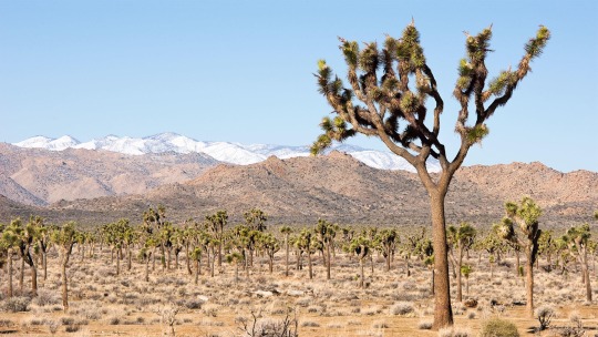
Joshua Tree National Park! Located in the intersection of two distinct desert ecosystems, Joshua Tree National Park serves as a vital migratory stop for birds transiting inland along the Pacific Flyway. Its seeps, springs, and streams are highly important for a wide variety of songbirds, raptors, and waterbirds passing through. The park’s climate will likely grow less suitable for Golden Eagles and other raptors, as well as the iconic Greater Roadrunner. However, other species such as Phainopepla, Cactus Wren, and Verdin appear poised to find a local climate that’s stable or improving for them. In order to retain the park’s vibrant bird population, it is recommended that land managers look to maximizing the water habitat on the park, reducing disturbance, and maintaining as much native plant opportunities as possible.

Katmai National Park and Preserve! Katmai National Park and Preserve in southwest Alaska is known for its brown bears, but natural wonders in the park abound. Like many places in Alaska, Katmai’s landscape is experiencing climate impacts from changes in snow cover to lake ice cover to glacial thinning and retreat, and other impacts will extend to its birds. 21 species could colonize the park as the climate changes over the next 30 years. Meanwhile, the park’s climate suitability is expected to worsen for 35 species, potentially resulting in these birds going extinct within the park by 2050. It is recommended that park managers prepare for an influx of bird species and closely monitor species that are at risk of extirpation from the park.

Kenai Fjords National Park! Kenai Fjords National Park, on the Kenai Peninsula in south-central Alaska, covers more than 500 miles of Pacific Ocean coastline. Its landscape is marked by icy waters, coastal fjords, spruce forests, mountains, glaciers, and icefields, such as the Harding Icefield—the largest in the United States. Many plants flourish here, including fireweed and mosses, and more than 190 migratory and resident bird species, such as the Bald Eagle, Black-billed Magpie, Black Oystercatcher, Peregrine Falcon, Steller’s Jay, and Horned and Tufted Puffins. Kenai Fjords National Park is recognized as an Important Bird Area.
0 notes
Text
144. Not only are there no hot-air registers, return air vents, or radiators, cast iron or other, or cooling systems—condenser, reheat coils, heating convector, damper, concentrator, dilute solution, heat exchanger, absorber, evaporator, solution pump, evaporator recirculating pump—or any type of ducts, whether spiral lock-seam/standing rib design, double-wall duct, and Loloss (TM) Tee, flat oval, or round duct with perforated inner liner, insulation, and outer shell; no HVAC system at all, even a crude air distribution system—there are no windows—no water supplies, drains, bathtubs, urinals, sinks, drinking fountains, water heaters, or coolers, expansion tanks, pressure relief valves, flow control, branch vent, downspout, soil stacks, or waste stacks, or fire protection equipment: smoke detectors, sprinkers, flow detectors, dry pipe valve, O.S. & Y. Gate valve, water motor alarm, visual annunciation devices, hose rack and hose reel whether a 2 1/2″ or 1 1/2′ valve, foam systems, gaseous suppression systems; nor any sign of daisy-chain wiring or star wiring or electrical metallic tubing (EMT), rigid conduit, wireways, bus ducts, underfloor ducts, a cellular floor, a raised floor, or for that matter wire of any sort, No. 36 to No. 0000 (#4/0), or electrical boxes—3 duct junction boxes etc., etc.— or plug-in receptacles, 3-prong grounded duplex or other, pots on pans or cans, or switch plates, switches, whether swing pole, dimmer or remote, or circuit breakers or fuses, whether lead, tin, copper, silver, etc., etc., with a voltage class from 12, 24, 125, 250, 600, 5000+, or even lights, whether electrical discharge, incandescent, or combustion, no flame arc or gas-filled, tipless, inside frosted, decorative, general service, 10,000 watt aviation picture studio, projection signal, Christmas tree, arc projector, photoflood, mercury, sodium, glow, sun, flash, black light, water cooled, germicidal, purple x, ozone, fluorescent, Slimline, Lumiline, Circline, rough service, Q coated, Bonus A-line, 75,000 watt, Quartzline, special service, DVY, DFC, iodine cycle, axial quartz, halogen cycle, bi-post, heat, brooder, red bowl therapy, silver neck brooder, quartz infrared, bent-end infrared, iodine cycle infrared, RSC base, red filter, Marc 300, Lucalox, multi-vapor, e-bulb mercury, 1,500 watt multi-vapor, Watt-Miser II, Magicube, Flash Bar, Flip-Flash, GE-500, composite, discharge forward lighting, Precise, 35.5 lumens, white Lucalox, standby Lucalox, high output Lucalox, Halarc 32 watt, Halarc 100 watt, Staybright XL, high intensity Biax, metal halide, to say nothing of communication systems such as public address, intercom, radio, TV, CCTV, SATV, VSAT, telephone, (PAX or PBX etc., etc.,) or data, signal multimedia designs, or BAS, BMS, BMAS automation; there are not even any moldings or other stylistic signatures such as casings, baseboards, or finished floors, linoleum, cement, whether fast setting, coloured, fiber reinforced, self-leveling, mortar, high early-strength, sand mix, silica sand, plastic, hydraulic, or sheet vinyl, tile, cork tile, terrazo, rubber, carpeting, epoxy, ceramic & stone, slate, aputit-siarvaq, or marble, whether white—Danby Imperial, Colorado Yule, or Carrara—or black or green; or hardwood, whether overlay, strip flooring with alternate joints, or herringbone, inlaid, basket weave, Arenberg, Chantilly, or Versailles parquet; in fact no wood anywhere, whether rewordd, treated western hemlock, yellow pine, cedar, wood-polymer, Engelmann spruce, pecan, southern magnolia, Colorado spruce, alpine fir, american beech, northern red oak, Canada Hemlock, red maple, sugar maple, eastern white pine, butternut hickory, shagbark hickory, american plane tree, eastern black walnut, ponerosa pine, white fir, northern catalpa, common bald cypress, american sweet gum, bur oak, California live oak, mahogany, Douglas fir, eastern cottonwood; nor any sign of a sub-floor, sheathing, drywall, any kind of insulating material, polyicynne or other; sills, sill plates, sill sealer, rebar, anchor bolts, let alone footings or foundation walls; or bricks, whether split paver or red bullnose, or wall studs, firestopping, or braces, nor evidence of floor joists, rafters, king posts, struts, side posts, ridge beams, collar ties, gussets, furring strips, or bed molding (at least the stairs offer some detail: risers, treads, two large newel posts, one at the top and one at the bottom, capped and connected with a single, curved banister supported by countless balusters) though among other things no wallpaper, veneer plaster, Baldwin locks, any sign of glass, whether clear, reflective, insulated, heat-resistant, switchable, tinted, bad-guy, antique; or even tin-plated steel, factory-painted steel, brass; or even a single nail and screw, whether sheet-metal, particleboard, drywall, concrete, drive, aluminum, silicon bronze, solid brass, mechanically galvanized, yellow-zinc plated, stainless steel, epoxy coated, black finish, Durocoat; to say nothing of the sheer absence of anything that might suggest a roof, whether pitched, gable, hip, lean-to, flat, sawtooth, monitor, ogee, bell, dome, helm, sloped, hip-and-valley, conical, pavilion, rotunda, imperial, or mansard; no westwork, ziggurat, brise-soleil, trompe l’oeil etc., fenestration, tierceron rib, coffering, tholos, strapwork, stoa, egg-and-tongue, sala terena, absidole, rotunda, revetments, reredos, flying buttresses, retablo, herm, bedevere, pavillion, pastas, narthex, lunettes, dormers, cottage orné, pendentives, cheek-walls, cavetto, abutment, nor vaulted chambers, whether quadripartite or lierne vaults, or Mihrab domes, turrets, minarets, minbars, porticoes, peristyles, tabliniums, compluviums, impluviums, atriums, alas, exceedras, androns, fauces, posticums, peristylums, vestibules, arcades, apses, naves, naos, pronaos, opisthodomos, nymphaeum, internal crepidoma, courtyards, paradegrounds, bailey, demilune, caponiere, tenaille, flank, postern, rampart, face, bastion, embrasure, curtain, keep, brattice, merlon, or battlement; nor—obviously—pilasters, pillars, friezes, entablatures, architraves, facades, pediments, stylobates, triglyphs, scotia, torus, fillets, finials, and flutes, capitals, whether Ionic, Doric, or Corinthian, with volutes, abacuses, rosettes, acanthus leafe, or metopes, guttas, mutules, acroterions, dentils, or modillions, or even tretoil, Tudor, stilted, horeshoe, ogee, lancet, or equilateral arches, most probably resembling basket handle though without any sign of a keystone, pier, spandrel, voussoir, springer, or import.
Picture that. In your dreams.
— Zampanò, House of Leaves, Mark Z. Danielewski
16 notes
·
View notes
Photo
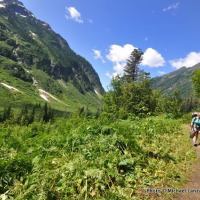
By Michael Lanza
On my first trip to North Cascades National Park, I was sure I’d found heaven. The hard-earned views of a sea of jagged spires and snow- and ice-covered peaks stretching as far as you could see instantly cemented the place as one of my favorite mountain ranges. I’ve returned many times, backpacking, climbing, ski mountaineering, and dayhiking and backpacking with my family.
But not many hikers and backpackers know much about Washington’s North Cascades, one of America’s least-visited national parks. And the season for heading into the backcountry there is upon us.
Check out the gallery of photos below; I think it will persuade you to put this park high on your list. Find links to my stories about the North Cascades below the photo gallery.
The North Cascades National Park complex includes the park itself—nearly 700,000 acres, 93 percent of which is designated as the Stephen Mather Wilderness—as well as the adjoining Ross Lake and Lake Chelan national recreation areas. Ecosystems range from virgin rainforest of giant cedars, hemlocks, and Douglas firs, to sub-alpine meadows carpeted in wildflowers, and alpine areas hosting about 60 percent of all the glaciers in the Lower 48. Everywhere, waterfalls pour down cliffs.
Few mountain ranges compare for the ruggedness, raw beauty, and remoteness and solitude of the dayhiking and wilderness backpacking here.
North Cascades National Park also has one of the most mind-blowing, spectacular backcountry campsites in the country (and one of my 25 best backcountry campsites ever).
Find your next adventure in your Inbox. Sign up for my FREE email newsletter now.
Check out all of my stories about the North Cascades, including “Primal Wild: Backpacking 80 Miles Through the North Cascades,” and “Exploring the ‘American Alps:’ The North Cascades.” The broader North Cascades region also includes the magnificent Glacier Peak Wilderness to the south of the park, and the Pasayten Wilderness to the north.
Tell me what you think.
I spent a lot of time writing this story, so if you enjoyed it, please consider giving it a share using one of the buttons below, and leave a comment or question at the bottom of this story. I’d really appreciate it.
Hi, I’m Michael Lanza, creator of The Big Outside, which has made several top outdoors blog lists. Click here to sign up for my FREE email newsletter. Click here to learn how I can help you plan your next trip. Click here to get full access to all of my blog’s stories. Follow my adventures on Facebook, Twitter, Instagram, and Youtube.
0 notes
Text
A Real Beauty
What do you think about my pic?
#lodgepole pine#Caribou Mountain#Carcross Desert#travel#original photography#vacation#tourist attraction#landmark#landscape#northern sand dunes#sand#tree#sub-alpine fir#woods#forest#floran#nature#countryside#cityscape#Carcross#Yukon#the North#Canada#summer 2023#world's smallest desert#What do you think about my pic?#photo of the day
21 notes
·
View notes
Photo

It is considered Mexico’s most biodiverse region.
15 vegetation types:
vergreen forest, sub-evergreen forest, subdeciduous forest, deciduous forest, sub-montane shrubland, cloud forest, oak forest, pine forest, juniper forest, fir forest, Alpine chaparral, temperate grasslands, xerophyllus grassland, xerophyllus scrubland and riparian gallery forest.
Thousands of plants
1,718 species of vascular plants and 124 species of macromicetes
131 species of mammals, 363 species of birds, 72 species of reptiles and 23 species of amphibians
Its more famous animals being ;
the Jaguar, the Yucatan Brown Brocket, the Mexican Black Bear, the Spider Monkey, the Otter, the Great Curassow, the Crested Guan, the Bearded Wood Partridge Dendrortyx barbatus, the Military Macaw Ara militaris, the Red-crowned Amazon Amazona viridigenalis, the Tucan, the Emerald Toucanet and the American Crocodile
http://www.unesco.org/new/en/natural-sciences/environment/ecological-sciences/biosphere-reserves/latin-america-and-the-caribbean/mexico/sierra-gorda/
0 notes
Text
Langtang Gosainkunda Pass Helambu Trek-18 Days
Langtang Gosainkunda Pass Helambu Trek is an adventurous Trek that combines a unique and one of the best trekking trails in Langtang Himalayan ranges. This trekking has three popular trekking trails; Langtang Valley, Gosaikunda Lake, and Helambu valley that lie to the north of Kathmandu valley offering numerous stunning views of mountains with rare varieties of vegetation and glimpse sight of wildlife. The main attractions are rhododendron and bamboo forests with an abundance of wildlife, majestic waterfalls flowing over mammoth boulders, a chance to bath in soothing hot springs, magnificent views of the snow covered white giant Langtang Lirung, Visiting the holy lakes of Gosainkunda. The Langtang Gosainkunda Pass Helambu Trek route goes through traditional, ethnic Tamang heritage villages and untouched forests of juniper, pine and so forth. This trek offers an opportunity to explore villages, to climb small peaks and to visit glaciers and sacred lakes at a comfortably low elevation.

The 18-day trek begins in Kathmandu with tours of the city’s UNESCO World Heritage Sites. Then we drive to Syabrubesi which is a Tamang village located on the banks of the Bhote Koshi River and begin our trek. We reach Kyanjin Gompa and then climb Tserko Ri the next day. From there we get tremendous views of the Langtang Lirung (7,200m/23,622ft) range. Next, we continue trekking in the beautiful Langtang Valley and reach Gosaikunda which is a revered place of pilgrimage for both Buddhists and Hindus. Moreover, the place is named after the glistening Gosaikunda Lake whose water is believed to have magical healing powers. We pass by a few more lakes on our trek and cross the Laurebina Pass. Our trek in the Helambu Valley begins after crossing the pass. Another highlight of our hike is to reach the top of Ama Yangri at 3,800m. The view of the Himalayas from the top of the hill is believed to rival that of Poon Hill. From here, Mt. Shishapangma and the Langtang ranges seem so close that we feel that we can almost touch them. We continue trekking in the Helambu region for a few more days and end our remarkable journey to the mountains with a drive to Kathmandu.
Detailed Itinerary:
Day 01: - Arrival at Kathmandu Airport
We will meet you at Kathmandu Tribhuvan International Airport and transfer to your hotel.
Day 02: - sightseeing tour of Kathmandu
The very next morning, you will have a full day sightseeing tour around Kathmandu valley. You can visit sacred Pashupatinath Temple and Swyambhunath, very ancient and essentially enlisted in UNESCO World Heritage sites. The biggest Buddhist Stupa at Boudhnath and the fine arts and historical architecture of Kathmandu Durbar Square reflecting the ancient Nepalese culture are highlighted on our guided tour.
Day 03: - Kathmandu drive to Syabru Bensi (1550m/5100ft) 7-8 hours drive
Today, we drive to Syabru Bensi. Enjoy the Himalayan views and mountainous lifestyle through the terraced fields and rustic villages. The scenery of foothills and ridgeline vistas goes through the Trishuli Bazaar, Betrawati and Dhunche you feel as if you are heading towards deep land. We take our Lunch at the Trishuli Bazaar before continuing further toDhunche. We descend down to Syabrubesi for the overnight stay.
Day 04: - Syabru Bensi trek to Lama Hotel (2450m): walking distance 6-7 hours, 1070m ascent - 10.9 km
The first day excitement trail crosses through the Bhote koshi River flowing down from Tibet and following the Langtang Khola. After a visit to the Gompa of Guru Rinpoche, follow the stone-paved main street out of town over Langtang Khola. After crossing the suspension bridge the trail gradually ascend up to Bamboo passing by landslide. The trail goes through the sub tropical forest which is cover by oak and maple, massive spruce, fir and blue pine. Afterwards, your trek ascends gently to Rimche (2400m). And at the end your trail is level to the Lama Hotel for the overnight stay.
Day 05: - Lama Hotel trek to Langtang Village (3430m): walking distance 4-5 hours, 980m ascent - 14.8 km
The day start with a gentle climb, but it soon becomes steeper, The tantalizing glimpse of snow capped peaks start appearing along with fleeting view of Mt. Langtang Lirung (7244m) through the trees. The trail ascends gradually as the valley opens up into classical U-shaped glacial. Follow the trail across the helipad and yak pastures, climb briefly through rhododendrons and scattered Tamang villages. The trail crosses a stream and climbs past several water driven mills and prayer wheels to the large settlement of Langtang (3430m), headquarter of Langtang National Park. The village has flat- roofed Tibetan style house and elaborately carved driven windows of the upper village is worth exploring.
Day 06: - Trek to Kyanjin Gompa (3870m): walking distance 2-3 hours, 460m ascent - 6.8 km
The trail winds through the village and climbs a ridge topped by a large chorten. It then climbs gradually past an impressive mani wall, crossing a stream to the small village of Mundu (3442m). After crossing several small streams with wooden cantilever bridges and moraines, you can finally see the monastery of Kyanjin Gompa and the dramatic icefall flowing from the peaks of Langtang Lirung and Kimshung. The surroundings are interesting also because of the famous Government operated Cheese factory. We have chance to test cheese and curd by Yak milk, it is remarkable of this place. After having lunch, we can explore the area with abundant panoramic views of Langtang Lirung (7246m), Genjempol, Kyangjin RI (4750m.), Tsergo RI (5000m.), Ganja la (5160m.), Langshisa- Ri (6427m.), Dorje Lhakpa (6430m.), Naya Kang (5844m.), Yala peak (5500m).
Day 07: - Acclimatization day in Kyanjin Gompa (3870m)
Today is the rest and exploration day of the trekking .We visit the monastery and the cheese factory or may walk up the moraine to see the spectacular ice faces and tumbling glaciers of Langtang Lirung or ascend Kyanjin Ri (4350m) and Tserko Ri (5,000m), which is highest point of this trek. Hike easy for a breath-taking panorama of the Langtang Lirung, Langtang range, Kinshung, Yansa Tsenji. We also have options to do a side trip to Langshisa Kharka. There are several alternatives sided trips, the surroundings areas of North having many smaller uninhabited valleys. Spend your night back to the Kyanjin.
Day 08: - Trekking back to Lama Hotel (2450m): walking distance 6 hours, 1430m descent - 21.6 km
Have your breakfast with observing surrounding genetic snowy capped mountains breathtaking view. We will follow the same trail back following the Langtang Khola to Langtang village and on to Ghora Tabela. After having a lunch stop continue steep descend to Lama Hotel. All the way downhill you will see fantastic views of towering mountain what you have missed on the way up.
Day 09: - Lama Hotel trek to Thulo Syabru Bensi (2230m): walking distance 6-7 hours - 13.1 km
The beginning trail gently descends along the river to the landslide then passes through pine and Junipers forests steeply up to Thulo (Big) Syabru. The trail offers magnificent views of red pandas, boar, monkeys and various species of birds. The Tamang Cultural Heritage “Thulo Syabru Gaun” preserves wonderful ethnic custom, culture and their traditional. Here, you can enjoy the amazing landscape and the magnificent nature with splendid views of Ganesh Himal (7110m), Langtang Himal and its ranges. Rest of the day explore around the small village of Syabru.
Day 10: - Thulo Bensi to Sing Gompa (3330m): walking distance 3-4 hours, 1040m ascent - 6.8 km
The trails lead us from Thulo Syabru follows a steep ascent path passing through Dursagang (2735m), passing aline of chotens. Along with the breathtaking views of Langtang Himal, Ganesh Himal, Tibetan Mountain, the trail continues steeply through the forests of oak and hemlock and then less steeply through rhododendron forest and pastures to the top of the ridge at Phoparng Danda (3190m). Watch the langur monkeys playing in the forest and a fine sunset views over the Ganesh Himal. The larger trail cuts across the ridge top, staying fairly level through silent moss-covered forests. Then the path gently ascends for a while and follows a flat level to the Sing Gompa. The local well managed cheese factory and a Buddhist Monastery’s can be the visiting places which provides panoramic views, exhilarating nature. Spend your night at teahouse.
Day 11: - Sing Gompa to Gosaikunda Lake (4460m): walking distance 4-6 hours, 1130 m ascent - 11.2 km
The trail today takes two parts. Initially the trail climbs steeply up a ridge that marks a transition zone between rich, moist mountain forests and dry scrub vegetation on the slopes. Slope is the sanctuary for the red pandas and providing magnificent view of snowcapped Ganesh Himal. The trail to LauriBinayak (3920m) is steep & continues for three hours. We follow a rugged trail with dramatic views to the west; Manaslu range, Ganesh Himal range, Tibetan peaks and to the north also across the valley is Langtang Lirung.
From LauriBinayak, the trail ascends now in alpine country above the tree line. Cross a small ridge to see first view of the holy lake of Gosaikunda. There are about a dozen lakes around Gosaikunda Basin, the main three being Saraswatikunda, Bhairabkunda and Gosaikunda. The myth is, Gosaikunda was created by Lord Shiva when he pierced a glacier with his trident to obtain water to quench his thirst after having swallowed a poison which threatened to destroy the world. Hundreds of pilgrims come here to worship and bathe during the full-moon festival every August.
Day 12: - Gosaikunda to Ghopte (3440m): walking distance 6-8 hours, 300m ascent and 1320m descent
After explore around at Gosaikunda, we start a bit challenge day. The trail traverses the northern side of Gosaikunda Lake and climbs on a rocky trail. We climb through rugged country, crosses glacier moraines and past four small lakes to the Laurebina La (4610m). On a clear day we can see Annapurna range through the way. Then the trail leads us steeply down to Phedi (3740m). From here, the route drops to the stream then climbs through the scrub Bamboo to a crest. Continue walk down throughout crossing a rocky hill with pine, rhododendron trees to Ghopte. At night you can see the lights of Trishuli Bazaar far below and Kathmandu glow behind the hills to the west.
Day 13: - Ghopte to Tharepati (3510m): walking distance 1-2 hours, 330m ascent
Descending from the ridge at Ghopte, the trail makes numerous ups and downs across ravines and the boulders of old moraines. The trail slightly descends and then begins to ascend through the rhododendron, oak and juniper forests up to the Tharepati. A steep path rises above the village to a fluttering white prayer flag on a windswept hilltop, offering a perfect panorama of the Langtang Himalaya. Spend your day strolling around the village.
Day 14: - Tharepati trekking to Melamchi (2560m): walking distance 4-5 hours
Heading east from Tharepati, the trail drops rapidly down the ridge. The path passes pine and rhododendron forest rich with bird life along with good views down into the Helambu valley. The ridge gives you a marvelous mountain view of the Jugal Himal and Numbur in the Solu Khumbu. Crossing the village and enter a forested area descending to Melamchi River followed to the Melamchi Gaon. Melamchi Gaon is surrounded by beautiful forests, which is mainly inhabited by Sherpa people with their unique culture and spectacular Buddhist monasteries.
Day 15: - Melamchi to Tarke Ghyang (2590m): walking distance 5-6 hours
From the Gompa in Melamchi Goan, the trail drops rapidly into the forest, passing a series of large chortens, a reminder of the strong Buddhist influence in the village. The trek descends steeply to the valley floor, where you can have a well earned dip in the crystal- clear stream named as Melamchi. After crossing the bridge the trail climbs steeply up to the sprawling valley of Nakote (1980m). Then the trail goes gently up to beautiful Sherpa village Tarke ghyang (ghyang means monastery) passing through Sherpa old settlements and biggest monasteries. Narrow cobbled lanes and tightly packed houses here resemble the high altitude villages of Mustang and Dolpo which are worth viewing. Tarkegyang boasts an 18th century Gompa with huge brass prayer wheel.
Day 16: - Tarkegyang to Sermathang (2610m): walking distance 5-6 hours
Today the trail is quite easy through flat land with beautiful forests. The trail leads us cross small forest with the view of beautiful village of Helembu region. Sermathang is another pretty Sherpa village where you can visit many ancient monasteries and view of Jugal Himal range. In the clear day the villages provide good views of Ganesh Himal, Langtang, Gosainkunda and Rolwaling, Even Everest also in a distance.
Day 17: - Sermathang to Melamchi Bazaar and drive back to Kathmandu: walking distance 4-5 hours and 3-4 hours drive
The trail gradually descends all the way to Melamchi Bazaar through meadows and cultivated fields. From here take a drive of around 3-4 hrs to the Kathmandu valley.
Day 18: - Farewell Departure
We will drop you to the International airport to catch your flight back to your home and wish for your Safe journey.
Note: The package can be redesigned or redeveloped as per your preference. For more information please e-mail us at [email protected]
whatsapp: +977 9841815039
#trek to langtang#langtang gosaikunda trek blog#langtang gosaikunda trek cost#langtang helambu trek map#langtang helambu trek itinerary#langtang gosaikunda trek map
0 notes
Text
Why is Manaslu and Tsum Valley Trek spectacular ?
The manaslu and tsum valley trek is one of the adventurous trek of Nepal. Himalayan gems to observe for a sparkling array of panoramic peaks, wide range of scenery with cultural variety. While on the trek, we pass through the alpine forests, glacial rivers .We can enjoy the warm hospitality of ethnic people. We also visit the ancient Buddhist Gombas of the region. We can see beauty of Milarepa's Cave, Rachen gompa, Mu Gompa among others. Trekkers visiting Manaslu and tsum are sure to have exceptionally unforgettable experience. Manaslu and Tsum valley trekking is exploring remote areas of Nepal Himalayas. The Manaslu and Tsum trekking are spectacular and adventours than many others.People come for trekking from all over the world. Manaslu region was opened for the trekkers only in 1995 and Tsum was also just opened in 2008.
Here are the some reasons of Manaslu and Tsum valley Trek being spectacular:
Ø Trekking to Tsum Valley
Ø Beauty of Tsum Valley
Ø Trekking To Manaslu Valley
Ø Beauty of Manaslu Valley
Ø Local Homestay
Ø Trekking to Tsum Valley
The trek to Tsum Valley (5,093 meters) takes you into the majestic surroundings of the Ganesh Himal, Sringi Himal, and Boudha Himal ranges. In the initial days of the trek, we explore the Budhi Gandaki Valley through a mix of dense forest, terraced fields and hill villages. As we leave the main Manaslu Trail for the Tsum valley, suddenly we get a feeling of entering truly into the hidden valley. While on the trek, we also pass through the alpine forests, glacial rivers, and enjoy the warm hospitality of ethnic people. We can visit to the ancient Buddhist Gombas of the region including the Milarepa's Cave, Rachen gompa, Mu Gompa among others.
Ø Beauty of Tsum Valley
Tsum valley is rich in unique culture, mountain, wildlife, freshwater Rivers, years old monasteries, and Lamas. Tsum is known as the hidden gems of Nepal. There are century-old monasteries and Nunneries. Staying in inside accommodation of Mu-Gumba and direct touch with local Lamas activities is really a marvelous. Exploration of the biggest nunnery is Rachen Gumba, where the only nun practices typical Buddhism.
Ø Trek To Manaslu Valley
Manaslu is around a height of (8,156m) is a mountain of Spirit being one of the eight highest mountains in the world. You can see a marvelous view of Mount Manaslu from very near in this trekking. Trek comprises sub-tropical Himalayan foothills to arid Trans Himalayan high pastures which bordering Tibet. The trekking route follows an ancient salt trading route along the Budhi Gandaki River. Trekkers can pass through the green forest, several gorges, beautiful waterfalls, typical villages, and the highest pass Larke (5,235m). The Manaslu Valley Trek has rough steep tracks and less than luxurious accommodation. It is culturally fascinating with strong continuing links to Tibet in the upper Buri Gandaki and the Tsum Valley. The view of Mt Manaslu, eighth highest mountain in the world is very marvellous and close. We we see the villages of Arughat, Lapubeshi, Doban, Phidim, Lo, Dharamasala Samdo, samagoan, Bumtang, tilche Jagatis inhabited by Gurung, Lama and Bhotias.
Ø Beauty of Manaslu Valley
You can get in touch with local peoples and their lifestyles by staying at their local homestay accommodation. You can visit an untouched valley, towards Dumje with the oldest nunnery, Gumba Lungdang (3,200m). A day hiking to Ganesh Himal Base camp from there is reaching 4,200 miters with spectacular Ganesh Himal and glacier following the bottom of Himalayas. The walk follows through a beautiful alpine woodland of tall rhododendron-pines-oaks and fir tree lines past interesting villages of Namrung-Lho and towards Samagaon, where tree lines decline for short high alpine juniper and rhododendron (azalea) bushes on this arctic cold terrain. The view of snow capped peaks as Cheo Himal, Himlung Himal and Kang Guru and Manaslu are clearly visible from Manaslu valley.
Ø Local Homestay
The Manaslu and Tsum valley trekking trail is with less crowded of trekkers. Basic tea house trekking lodges have built-in both Manaslu and Tsum valley region. Friendly and hospitality peoples, living Buddhist cultures, Tibetan lifestyle and untouched wildlife in the area is making this trekking as untouched and remote area of Nepal.We can see Buddhist performing Buddhism culture all over the trek.
For Manaslu and Tsum valley Trek , we require a compulsory trekking guide and a minimum of two trekkers. The permit can only obtain by a registered trekking office. Trekking enters through the Manaslu region so that the permit of the Manaslu Conservation area also needs to be issued. Besides that permit of Annapurna Conservation Area is also need if you are doing Manaslu circuit trekking through Larke Pass (5,213m) and end at Dharapani Annapurna. The map forManaslu and Tsum valley Trek is available from Kathmandu which make trekkers easy for trekking.
#Manaslu and TSum Valley Trek#Tibet Lhasa Tour Package#Tibet Group Joining Tour#Upper Mustang Trekking#Annapurna Base Camp Trekking#Everest Base Camp Trek#Everest Heli Tour Package#Everest View Tour Package
0 notes
Text
BC Spirits "Spirit a Day" #58 - Montis Distilling Alpine Gin
Wanted to take it back to the basics today with this fantastic gin from Montis Distilling, the only distillery in Whistler. Coniferous pine, resiny juniper and a fruity sweetness on the palate. This is a great versatile gin to try in your favorite cocktail.
Alcohol - 45% / 90 proof
Color - Clear
Nose - Coniferous high notes with resinous sap, hints of citrus and a light look into the base spirit
Taste - The base spirit hits you first, then a unique fruit sweetness, maybe stone fruit or pear then the juniper in the form of coniferous and light citrus notes
Finish - Clean, bright citrus notes and fir tips
Best Enjoyed - This is a perfect sub for traditional macro produced gins
youtube
#spirits#bc spirits#spirit#bc#craft spirits#spiritis#craft spirit#tayton bay spirits#taynton bay spirits#okanagan spirits#spirit bear#bc distilleries#bc liquor whisky#spirit box sessions#free spirit spheres#bc whisky#young spirit love#bc distillers#british columbia#best#bc canada#whisky#whiskey#invermere bc craft spirits#craft#local craft spirits#craft spirits event#craft whisky#craft gin#craft rum
0 notes
Text
Best Trekking Adventure In Nepal: Annapurna Circuit Trek
One of the Best Trekking Adventures In Nepal is Annapurna Circuit Trek. The trek is packed with everything a mountain lover would hope for while on a trip. The Annapurna Sanctuary was opened for tourism and treks in 1980. Since then, the expedition has become one of the most popular treks of all time. The trail leads you amongst beautiful forests, filled with Rhododendron trees and Alpine trees. You get the best views of the surrounding mountains around the Annapurna Range. You will also come across the hot water springs on this trip. So let us learn more about the best trekking destination in Nepal under the following categories:
Nepal Tourism
A brief intro of Pokhara
What to explore in Annapurna Circuit Trek?
Itinerary for Annapurna Circuit Trek
Which is the best time to go for Annapurna Circuit Trek?
Nepal Tourism
Nepal is a small landlocked country in Asia. Though small, the country is rich in heritage and culture. It has numerous Hindu temples and Buddhist Monasteries where people visit every day from everywhere. Nepal is also famous for having most of the highest peaks in the world within its territory. That is one of the key factors that has made Nepal famous among tourists. Consequently, tourism has become the main industry for the economy of Nepal. Every year, thousands of tourists from all over the world, visit Nepal. Not just for the fun of it or for the thrill of it. But for all of the things that have taken Nepal’s tourism to such huge heights.
Therefore it is safe to say that Nepal has a booming tourism industry. Due to the high demand of tourists, the Nepalese government has taken many initiatives for tourist sites. The trail leading to the mountains in the Himalayas are preserved in order to make your adventures fruitful. Not only this, but also the government takes action to see the lodges and tea houses are in good order. As a result, Nepal’s tourism has taken a monumental leap in providing the best traveling experience for the tourists.
A brief intro of Pokhara
Pokhara is situated in the Gandaki Pradesh province of Nepal. It is also the capital city of Gandaki Pradesh. Pokhara is the 2nd largest city in Nepal and is a gateway for many beautiful places in Nepal. It is located 200 km from Kathmandu. The city is famous for its enchanting Phewa Lake. The Annapurna Range falls within the valley of Pokhara. Pokhara is considered as the tourism capital of Nepal is the base for trekkers traveling to Annapurna Base camp. Pokhara is also home to a large number of elite Gurkha soldiers. The nearby hills around Pokhara are surrounded by Gurung Villages with few places belonging to the Khasi community. Small Magar communities are also present in the southern outlying hills.
The altitude of the place varies from 827 meters to 1740 meters. Therefore the weather there is a mixture of warm and cool breeze, but it is not so cold even during winters. Even though the nights can get chilly due to the wind coming from the Himalayas. The nightlife of Pokhara is also an active one. You can find live music and clubs and bars open for people at night. The porous underground layer of the Pokhara valley has favored the formation of caves. Hence, many caves can be found within the city limits as well.
What to explore in Annapurna Circuit Trek?
As mentioned earlier, Annapurna Circuit Trek packs a lot of exciting elements to make your trip a splendid adventure. This trek is not only famous for your trekking experience. But also for the natural hot springs, the world’s deepest Kali Gandaki Gorge and the world’s highest lake (Tilicho Lake). It is also famous for the candid landscape and the stunning Ruptse Waterfall which falls on the trail.
The Annapurna Sanctuary is stretched over a huge area. This sanctuary is filled with a variety of Orchids, different colored Rhododendron trees, Fir and Alpine trees. Bamboo trees are also prominent in these areas. The dense sub-tropical forests are filled with over 400 species of birds and animals. You can definitely come across a variety of birds, but you need to be lucky to see some mountain animals. For instance, animals like Marten, Deer, Langoor and the Snow Leopard are rarely seen in these parts.
Annapurna Circuit Trek takes you through many quaint villages inhabited by friendly faces, isolated Hamlets along with picture-perfect scenery. The settlements we stay in are mostly cozy structures commonly called tea houses and a few lodges. Apart from all this, the views you come across during your trip is of course, magnificent. You will have sightings of the many mountains ranges around the Annapurna region. Like Annapurna I, II, III, IV, Dhaulagiri, Annapurna South, Manaslu, and Macchapuchhre.
Itinerary for Annapurna Circuit Trek
Your exhilarating adventure for Annapurna Circuit Trek starts from Kathmandu, Nepal, where our headquarters are located. Once you reach the airport or our office at Thamel, our working staff will be assigned for your trip. You will be escorted to your hotel in Kathmandu and you can settle down first. In the evening, our staff will conduct a brief session on the importance of Acclimatization at higher altitudes. Rest for the day.
In the morning, we have the whole day for sightseeing. Our tour guide will take you to the holy places in Kathmandu. The first destination is Boudha Stupa, built in favor of the Lord Buddha. Then we visit the holy temple of Lord Shiva, Pashupati Nath. If time permits, we can go visit the Swayambhunath after a hearty lunch of Nepali cuisine. In the evening you can take a stroll through the bustling market of Thamel to get your last-minute shopping done. We rest for the day at the hotel.
After breakfast, we start off early and first drive to Besi Sahar (760 m). The road leading to Besi Sahar is well maintained. After reaching Besi Sahar, we begin our trek towards Bulbule. It is an easy and short walk with the Marya Sangdi river close by. After 2 hours, we reach Bulbule. You will be lead to the lodge there and you can freshen up as we rest for the night.
Early morning, we wake up and after breakfast head uphill. We will need to cross several suspension bridges to get across from Marsyangdi Khola. During the trek, we also come by small waterfalls and rice fields. After going through a small forest we reach the cliff at Jagat. It is a good viewpoint to see the Marsyandi Khola flowing in the foothills of the valleys surrounding it. At the tip of the cliff, you can see a cluster of beehives too. We continue further till we reach Chamje (1425m) and rest for the night at a village lodge.
The next day, we take the hike past narrow steep valleys and dense forests filled with Rhododendron, Pine and Bamboo trees. As we move forward, we reach a wooden bridge that takes us across and further uphill to a wide valley. The view is splendid from where you stand. We continue our ascent towards the village of Tal. Here we have our lunch before we continue. We walk past small fields of barley, wheat, and potato for a while till we reach Dharapani. You can refill your water caskets in one of the natural growing springs. From here we take a west turn through another set of fir and pine-filled forest, to reach Bagarchhap (2160m). We halt for the night here.
Next, we hike from Bagarchhap to Chame (2651m). The first few clicks will take us to the village of Danaque. From there, it is a steep climb towards a few smaller villages in the area inhabited by Tamangs and Tibetans. The villages have great views of Mount Manaslu, Lamjung and Annapurna. You can also observe the change in landscape and house designs as you reach the Tibetan region. We continue on the trail till we go past Than Chowk, Kolo finally to reach Chame. Halting for the night here at a local tea house.
In the morning, we trek towards Pisang (3333m). First, we go beyond the old part of Chame. Then we climb up to Telekhu and thus continue to follow along and leveled trail through smaller forests. Until we reach Barthing. The trail takes us to a suspension where we need to cross the Marsyangdi river again on the south bank. Consequently, the route takes a steeper climb to reach a pine-forested ridge. The ridge levels again as we proceed further from Manang Valley’s upper region. Then after a few corners, we reach the village of Pisang. Here we halt for the night.
Next, we head towards the Manang district (3351m). Pisang actually stands as the starting point for the Upper region of the Manang district. As we make our way uphill, we reach the Tibetan styled village of Braga. The structural composition of the houses here is definitely unique as one can see for themselves. The village has the largest monastery in the district, the Braga Gomba. It is located on a high cliff with the best view of the entire village. And the interior as a wide array of statues on display. We leave Braga after lunch and head up till we make our way to Manang. Here we refresh ourselves and rest for the night.
The day is kept aside for acclimatization. Acclimatization is a very important process to adjust to the high altitude areas. It helps you to avoid sickness and at the same time, you can enjoy the trip to the fullest too. As a part of acclimatization, a short hike will be conducted to Khangsar in the afternoon. It is a beautiful place with a natural setting. We rest for the night once we are back at Manang.
I hope you are rejuvenated after the rest. This day we make our way towards Yak Kharka (4020m). We walk past tall trees towards the alpine grass and junipers strewn along the path. We come across a few meadows where you can see a few horses and yaks grazing in the fields. The slopes of Yak Kharka is a perfect location to spend the night with its serene surroundings. We rest for the night in the village.
In the morning, we trek to Letdar first as it helps in further acclimatization. The trail becomes steeper as we proceed to reach the east bank of Jarang Khola. After enjoying the spectacular view, we continue further to reach Thorung Phedi (4430 m). It is a peaceful village surrounded by vertical cliffs. There are chances of coming across a few mountain animals in this area. The most common sightings are Lammergeiers and Griffons. Whereas you will have to be lucky to spot a blue sheep or a snow leopard loitering around the region. We halt for the night in the village.
After breakfast, we travel along the well-used route towards Thorung La (5416 m). The trek is a long one and can take up to 8 hours to reach the point. The trail has been used for a long time, and it is a comparatively easier ascent. Although the strong wind at the upper regions can make it a bit tough to walk steadily. The route is believed to have been used for herding sheep and yaks to and from Manang, for trading purposes. As we hike further, we reach Thorung La Pass.
The Thorung La pass is the main vantage point for wonderful views of Annapurna Range and Gangapurna. After taking in the magnificent view of the surrounding ranges, we rest for a while at such a great viewpoint. Thereafter, we descend towards the village of Muktinath (3800m). The descent will bring us among glorious views of the Dhaulagiri range at a distance. After a few clicks, the route becomes straighter as we enter grassy plains with serene meadows. A bit further and we reach Muktinath. We spend our night in the village.
Muktinath is famous for the Hindu Jwala Mai temple and several Buddhist monasteries. The village is believed to be a holy site where people from all over the world come and visit. Most of the people coming to Muktinath are either trekkers or people coming to pray at Jwala Mai temple. The temple is blessed with a spring and an eternal flame with 108 water sprouts pouring holy water. At this altitude having cold water poured over your head is really extreme. But thousands of people come every day to take a walk beneath the 108 water sprouts early in the morning.
You can choose to take a bath in the early hours of the day if you want. But after breakfast, we take to the trail leading our way towards Jomsom (2720m). The trail leads us through grassy meadows, clear streams and trees bearing various fruits. Further down, we reach Kagbeni, where we have our lunch. After filling our stomachs, we hike down the Kali Gandaki valley till we reach Jomsom. The altitude has decreased drastically, so you might feel a bit warm. However, Jomsom is known for the cold wind that blows through the town frequently. We halt for the night at Jomsom lodge.
In the morning, we head downhill still. Make sure you know the technique of walking down a slope or a valley efficiently. As we make our way down we first reach the quaint village of Marpha. The route from Marpha to Tatopani takes us through the village of Chokhopani. This is a very recent route. We can get fantastic views of the Nilgiri, Dhaulagiri, Tukuche, and Annapurna while walking on the trail. Mid-way we also come across natural hot water springs. We can spend some time here, and relax. After a while we continue downhill, then reach a suspension bridge. The bridge takes us past the KaloPani river, then finally we reach Tatopani (1189m). Here we halt for the night.
After having breakfast, we move towards Ghorepani (2855m). The terrain of the villages we walk past is mainly made of terraced fields and inclined farmlands. The hike gets steeper as we move further, and we come across Rhododendron trees, Magnolia trees, and other wildflowers. The landscape is greener as we proceed till we finally reach Ghorepani. Ghorepani is a small village previously used by traders as a resting spot. In a literal sense, ‘Ghorepani’ means ‘water for horses’. The view of the mountains in the evening sky is a wonderful phenomenon witnessed at Ghorepani. We halt for the night at a nearby tea house.
We wake up early today to get the best view of the sunrise from Poon Hill. Poon Hill is a great vantage point to witness the sight of the Annapurna and Dhaulagiri ranges as well. One cannot forget this spectacular view ever in his life. Poon Hill is also correctly known as a ‘Photographer's Paradise’. We will stay there for some time, then head back to Ghorepani for our breakfast. After breakfast, we go downhill again and make our way towards Tikhedhunga. The valley is a fascinating sight, with the mountain ranges a bit far out in the distance now.
The trail is quite steep as well before we reach Tikhedhunga. We have our lunch in the village. After that, we trek further down the valley. The terrain is mostly terrace fields and grassy meadows before we reach Nayapul. We take a short drive back to Pokhara after we reach the village. At Pokhara, you will be taken to your hotel. You can choose to rest or agree to take a stroll around the city. It is back to civilization for the trip. We rest at the hotel there.
The next day, we can go for a short trip to Phewa Lake after breakfast. Thereafter we take 6-7 hours to drive back to Kathmandu. Upon reaching Kathmandu, you can take a stroll around Thamel bazaar and get your souvenirs to take back home. With this, your trip comes to an end. In the morning, depending on your flight plans, one of our staff will escort you to the airport.
Which is the best time to go for Annapurna Circuit Trek?
The Annapurna Circuit Trek is a very popular trek. And as you can imagine, people from all over the world come to take the trip every season. The weather is a bit unpredictable in the Himalayas. But based on past expeditions, Spring and Autumn seasons are the best seasons to take the trek. However, being the best season also has its flaws. The rush of tourists during these two seasons is also promising. Travel agents usually have a tough time arranging the trek during the seasons.
So, if the booking clears through, you are up for a great experience. During Spring and Autumn, the sky is blue, and the trail is cleared with unobstructed views of the peaks. The weather is also peaceful after Winters and after Monsoons. You will find greenery and freshness all around the trail. Lots of birds and animals are also sighted during the Spring and Autumn seasons.
Monsoons are not the best time to come here. The trail is muddy and there are chances of getting injuries. Rain will only make the hike a disaster. Plus the cold at that altitude can make you fall sick easily. Winters also is not a good time to make the trek. The views and the trail can get really foggy. Some of the passes are blocked due to heavy snowfall. Snowfall is another reason the trek can be a hectic one. Some of the lodges and tea houses also remain closed during winters due to the harsh weather.
0 notes
Photo

[seeds] alexstrohl: Walking among the sub alpine firs on the way back from the Jewel Basin. My favourite tree in the North West.. 9.25.17 • Instagram A look back at the start of Autumn ‘17 in True nature
0 notes
Last Seen Blogs

indywasdeepfried
Look, Gordon! Ropes! We Can Use Them For Big Pits

hatsunemix-blog
Hatsune Mix

rosetumrp-blog
rosētum academy

atealiers
trapped in the amber

theweepingguitar
matilda