#wakhi people
Text


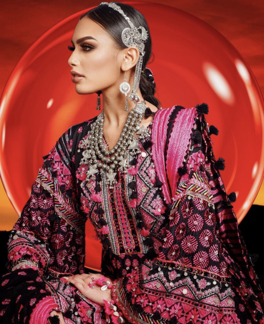


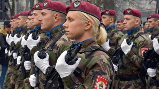
Miss Universe Pakistan 2023 National Costume
The name of the National Costume is Pehchaan or in English 'Identity' Meaning: the distinguishing character or personality of an individual: INDIVIDUALITY Everyone has their own Pehchaan (Identity Miss Universe Pakistan message on her national costume is 'Unity in Diversity by celebrating its own Identity' Erica aims to celebrate the rich and diverse culture, history and lifestyle of Pakistan through her outfit. Pakistan is home to multiple ethnicities based on region, religion, language, and culture. Few of the existing ethnicities include Baloch, Brahui, Sindhi, Punjabi, Muhajir, Saraiki, Memon, Kalashi, Balti, Wakhi, Afghani, Kashmiri, and Hindkowan. This costume is a vibrant celebration of Pakistan's diverse cultures, seamlessly weaving together its distinct beauty and the profound love and unity embedded in its people's hearts. The intricate patchwork blends the rural and urban elements, paying homage to the rich crafts and heritage of Pakistan. The handcrafted fan, a major part of Pakistan's tribal lifestyle, is a symbol of power, and elegance and an ode to its roots. Meanwhile, the grand silhouette serves as a powerful visual testament to Pakistan's remarkable growth and evolution over time. It embodies the nation's journey from its roots in tradition to its strides toward modernity since gaining independence.
110 notes
·
View notes
Photo

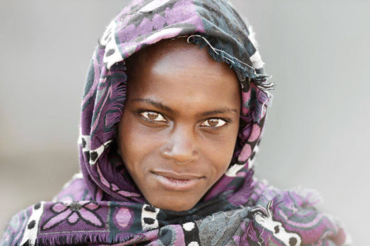
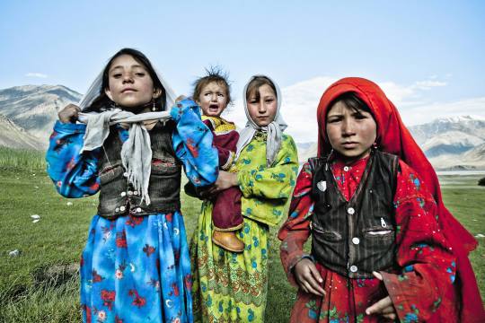
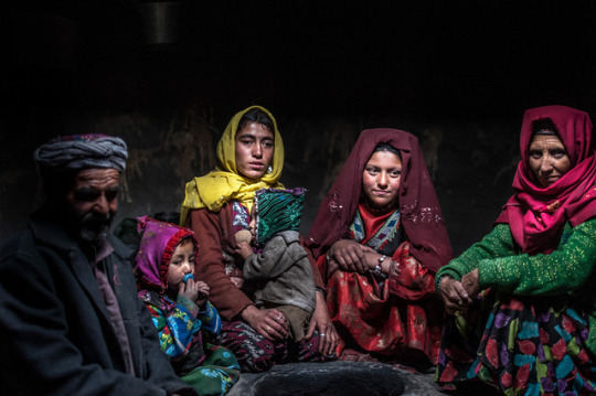
Maryam is getting dressed for her traditional Wakhi wedding. At the top of the frame in the background, the Ismailia spiritual leader looks as if he is blessing her. Beliefs remain strong but traditions are evolving in the valley. Wakhi people have often praised the high education rate in the community, which probably has allowed Maryam and her future husband, from the new generation, to choose each other. The short ceremony will start soon at the Jamatkhana, the place of worship. While the restricted ceremony takes place, children will carry on the tradition by hiding the groom‘s shoes. A few rupees will be enough to get them back!
Camille Delbos
59 notes
·
View notes
Note
Salam wa Alaikum! Sister, how do you think Gilgit and Baltistan feel about Afghanistan Asif? Are they afraid of him? Not in a bad way, but more like they know where they stand if they cross paths with him. *I noticed that alot of what I would assume are Farsiwans have been quick to point out that Asif has a Tajik population so does this cause some sense of cordiality between Umer's Northern Provinces and Asif?
Hmm you see, i've talked a bit with Huzaifa on this. Pakistan's Northern regions ( Gilgit-Baltistan ) and some neighbouring surrounding communities exist in their own separate and isolated sphere of cultural influence. Basically, the members of this isolated bubble are:-
( Gilgitis, Chitralis, Nuristanis, Kalash, Wakhi, (pamiri too i guess?) baltistanis to an extent too but they're also influenced by tibet) etc
These ethnic groups are more tightly connected together as opposed to mainland Afghanistan, mainland Pakistan or distantly, Tajikistan. Our influence on them is much less. So as i've said before, they're a mixture of Indic-Iranics, who share alot with one another (and are more closer to one another than the other indics/iranics they share their linguistic identification with) as well as minor influence from other surrounding spheres of cultural influence.
To answer your question, No, they're not afraid of Asif. They're also very proud people, but calm about it. They've probably not had much to do with him other than previous history with Asif's Wakhi and Nuristani provinces. Before these lands were given to Afghanistan during the colonization period, they were one with the Kingdom of Chitral and Gilgit Baltistani regions). Also, due to them inhabiting one of the most mountainous regions in the world, they've remained very isolated throughout their history. I think, Asif is not very aware of them either and often mistakes them off of as northern branch of pashtuns/tajiks or something. This is something that annoys them though, they don't like getting mistaken for Pashtuns or Kashmiris x'D
#Gilgitis and Baltistanis are more pacifistic and humanist than Pashtuns etc etc#so where you imagine the Pashtuns as being more hot-headed and impusive#you can see gilgit baltistanis as more calm and collected folk lol#ooc#answered ask#thanks for asking!
10 notes
·
View notes
Note
You are saraiki perhaps? Very warm and kind people and honestly my favourite pakistani people next to the wakhis in gilgit
ah I wish, I think that's such a beautiful language and would love to learn it!
#my fam is of kashmiri descent :)#my dadi is punjabi tho so we kind of retain aspects of both cultures#Anonymous
0 notes
Photo


WHAT IS YOUR ETHNICITY 1.WHAT IS YOUR ETHNICITY? AMONG YOUR RACE WHAT IS YOUR INDIVIDUAL FAMILY GROUP DO YOU BELONG TO.   Underwood’s DNA test showed that he is a descendant of the Babungo people of Cameroon. Additional DNA testing and genealogical research revealed that his African ancestry comes from the Bamum, Brong and lgbo ethnic groups of Western Africa   BHIL PEOPLE OF ASIA   ROMA PEOPLE OF EUROPE   ZULU PEOPLE OF AFRICA   SLAVS PEOPLE OF EUROPE   SPANIARDS OF EUROPE   SAMI PEOPLE OF EUROPE   AMAZIGH PEOPLE OF AFRICA   AMHARA PEOPLE OF AFRICA   PASHTUN OF ASIA   PASHAYI PEOPLE OF ASIA   WAKHI PEOPLE OF ASIA   TIKAR PEOPLE OF AFRICA   MASA PEOPLE OF AFRICA   Krio people from Sierra Leone, Yoruba people from Nigeria and Limba people from Sierra Leone 
#krio#krio people#sierra leone#yoruba#limba#africanancestry#african ancestry#european ancestry#asian ancestry#africans#asians#europeans#euroasia#masa#tikar#cameroon#wakhi#wakhi people#pashayi#pashtun#pashtun people#amhara#amhara people#roma#romain#roma people#zulu#zulu people#oromo#oromo people
356 notes
·
View notes
Photo
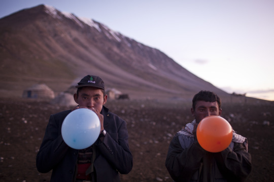
A Kyrgyz and a Wakhi, both yak herders, play with balloons in Uch Jilga.
Source: Theodore Kaye
#afghanistan#afghan#afghan people#afghan man#badakhshan#wakhan#wakhan corridor#wakhi#pamir#pamiri#kyrgyz#turkic#balloons#rural#mountains#herder#shepherd#village#play#photography#asia#asian#central asia#south asia
27 notes
·
View notes
Photo

Wakhi mother and daughter, Afghanistan, Eric Lafforgue
#wakhi#afghanistan#central asia#asia#people#culture#traditional clothing#tradition#folk clothing#folk#traditional fashion#geography#diversity
42 notes
·
View notes
Video

flickr
Afghanistan by Robertino Radovix
Via Flickr:
Wakhi mother and daughter, Wakhan Corridor
#Wakhan corridor#Wakhi#people#people of the World#persone#afghanistan#NatGeo Faces of the World#NatGeo#National Geographic#ritratto#ethnicity#woman#cildren#Faces#roberto radovix#photographer#culture
2 notes
·
View notes
Text
IN PICTURES | REMOTE PLACES | AFGHANISTAN
A New Road To An Inaccessible Land

— By Simon Urwin | 2nd July 2021
Once an isolated region barely touched by the hands of time, Afghanistan's Wakhan Corridor stands on the brink of great change with the building of a new road linking it with China.

On the Cusp of Six Borders
Bordered by China, Iran, Pakistan, Tajikistan, Turkmenistan and Uzbekistan, the Islamic Republic of Afghanistan lies at the very heart of Asia. Home to more than 32 million people, a quarter of its population lives in large urban centres such as Mazar-e Sharif (pictured), located 320km north-west of the capital Kabul. The fourth-largest city in the country, its centrepiece is the Shrine of Hazrit Ali – a masterpiece of Islamic architecture, which, according to local legend, is the burial place of Ali, the cousin and son-in-law of the Prophet Muhammad. The shrine is also renowned for its flocks of white doves. Locals believe that a small speck of another colour on a bird's feathers will instantly turn pure white when in the sacred building's vicinity. (Credit: Simon Urwin)
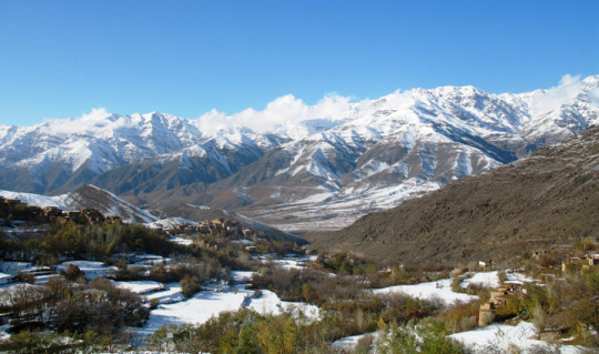
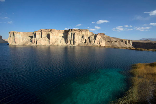
A Remote Corridor
Some 600km to the east of Mazar-e Sharif, the Wakhan Corridor (pictured) is a world apart from the rest of the country, both culturally and geographically. This 350km-long panhandle, in the region of Badakhshan, sits at the convergence of three of the world's major mountain ranges: the Hindu Kush, the Karakoram and the Pamirs – known as the Pamir Knot. "This is about as far away from the noise, the traffic and the muezzin's call to prayer of urban Afghanistan as you can get," said James Willcox of untamedborders.com, one of just a few adventure travel companies in the world that arranges trips to the region. "It is barely habited and hard to get to; few people even know of its existence. It's undoubtedly one of the remotest, and most beautiful places in the whole of Asia." (Credit: Simon Urwin)
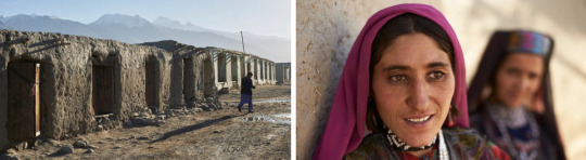
A Rural Life
Scattered along the Wakhan Corridor are small rural settlements like Khandud (pictured), their simple houses made of stone, mud and timber. Some of the larger villages are connected by a single dirt track, often made impassible by the waters of the River Panj. "Very few people have their own car in the Wakhan, but we have community transport – as well as donkeys, and our feet, of course," said Azim Ziahee, a resident of the market town of Ishkashim, located 80km away at the Corridor's western end. "The Wakhan still remains very cut-off though. Some villages are more than four days' walk to Ishkashim. The nearest big town from here – Dushanbe, the capital of Tajikistan – is a three-day drive. The isolation keeps the corridor like a time capsule. We look over to the border towards Tajikistan, with its electricity, paved roads and mobile phone signal, and say that it's like looking 100 years into the future." (Credit: Simon Urwin)
Home of the Wakhi
For more than 2,500 years, the Wakhan Corridor has been the homeland of the Wakhi people and is now home to a population of around 12,000. While the majority of Afghans are conservative Sunni Muslims, the Wakhi are Ismailis, who belong to the Shia branch of Islam. Here, women do not wear the burqa, and there are no mosques; instead, the Wakhi visit jamatkhanas (houses of prayer that also serve as community halls for conducting village business). "Ismailis are considered less strict than Sunnis," said Willcox. "For example, in the Wakhan, a Western male visitor can ask permission to take a woman's photograph without causing offence. Elsewhere in Afghanistan that would be unthinkable. (Credit: Simon Urwin)

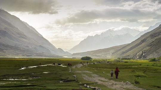
The Rhythm of Life
The Wakhi are farmers, cultivating wheat, barley, peas, potatoes, and apple and apricot trees in the semi-arid conditions of the corridor; their fields fed by melt water from mountain glaciers. Wealthier families have sheep and goats along with a few camels, yaks, horses and donkeys. "Every June, the Wakhi take their livestock to summer pastures, up as high as 4,500m, where the animals grow fat on the rich grass," said Ziahee. "The migration is called the 'kuch'. We also have the 'Chinir', which is our festival in early August to celebrate the start of the barley harvest. In the towns of Afghanistan, the five daily prayers form the structure of the day, but here, we feel a great connection to the land, and whilst we pray daily, the rhythm of life revolves more around the fields, the seasons and nature." (Credit: Simon Urwin)
A Centuries-old Tradition
One of the most distinctive traditions of the Wakhan is the centuries-old game of buzkhasi, sometimes described as rugby on horseback with the body of a goat as a ball. Thought to be an early pre-cursor to polo, buzkashi has no rules and no sides. There is certainly no sense of "fair play", as competitors will punch and whip each other in an effort to steal the goat, and broken bones are not uncommon. "The Wakhi villages love to play each other, especially at Nawruz, which is the Afghan New Year," Ziahee explained. "But here it's different to other parts of Afghanistan. Elsewhere, buzkashi is more political – put on to show the power of the elite, or by a politician as a way to win votes. Here, it is all about the competition and the community. It is one of many things that makes the Wakhan so unique." (Credit: Simon Urwin)
Untouched By Tourism
While Afghanistan's security situation dictates that much of the country is off-limits to foreigners, the corridor's relative safety, alongside its pristine mountain scenery and well-preserved Wakhi culture, has seen its appeal with off-the-beaten-trackers grow markedly in recent years. "At first there were only a handful of visitors," said Ade Summers, an adventure guide who has led nine expeditions to the Wakhan. "Over a decade, that's slowly grown to up to 600 people a year. It's a privilege to visit somewhere so untouched by mainstream tourism, where you can engage with people who still relish their traditional way of life. As you journey along the Wakhan, not only is it very beautiful, every step you take is like turning the pages of a fascinating history book." (Credit: Simon Urwin)

Part of the Silk Road
For hundreds of years, the Wakhan Corridor was an important route for merchants travelling along the Silk Road, the trade route that emerged in the 1st and 2nd Centuries BCE linking China with the Mediterranean. "Those merchants carried Chinese silk, Persian silver, Roman gold and Afghan lapis lazuli, mined here in the Badakhshan region," said Summers. "We find rock art detailing the road's history, such as petroglyphs of camels walking in single file as a trade caravan." Travellers and pilgrims followed in the merchants' footsteps. "Marco Polo is said to have passed through here on his way to China in the 13th Century, also Alexander the Great. We can still see the remains of historic travellers' shelters known as rabats, as well as ancient Buddhist stupas." (Credit: Simon Urwin)
A Strategic Place
In the late 19th Century, the Wakhan Corridor played a key role in the so-called "Great Game" between Great Britain and Russia. "When the Russians and the British were fighting for control of Central Asia, Afghanistan was hugely strategic,", said Willcox. "The Wakhan's current boundaries were formed in 1893 to create a buffer zone to prevent both parties' territories from touching each other – in this case, the British Raj and the Tsarist Russian empire. It eventually turned an old trade route into a cul-de-sac. More recent, history has seen the Wakhan caught up in the Cold War; and now the latest changes in geopolitics will have perhaps an unexpected consequence, with China's Belt and Road Initiative turning it into an important trade route once again." (Credit: Simon Urwin)

New Construction
Until recently, the dirt track from Ishkashim reached only as far as Sarhad-e Broghil in the centre of the Corridor. Onward travel east was only possible by foot or with pack animals. Now though, with Belt and Road construction, the track has been extended by some 75km, as far as the village of Bozai Gumbaz, around three quarters of the way along the Wakhan. "It follows an old trading route that the Kyrgyz nomads take to get to Sarhad from where they live around Chaqmaqtin Lake," said Summers. "The bulldozers have come in, and while they've only constructed something the size of a farmer's track, the potential consequences are much bigger. The Chinese are said to be building the stretch that will eventually connect their border with Bozai Gumbaz, something that will open up the cul-de-sac once more. Ultimately, it will give China great access to the markets of Central Asia and beyond." (Credit: Simon Urwin)

Mixed Emotions
Ziahee says that the people of the Wakhan have mixed feelings about the road's potential impact. "Some things will be good for us," he said. "We will be able to buy goats from China which will be much cheaper than from the market in Ishkashim. We hope to have access to better healthcare, too. At the moment, many of our facilities are very limited. But we worry that the unique Wakhi culture and slow way of life will be changed forever. We love the silence and beautiful nature, but fear that it will be destroyed by traffic pollution. Building a road takes a long time in the mountains, but we think in the next year or so it will be completed. Both the Chinese and Afghan governments want it to happen. Only time will tell what the future holds for us as a result." (Credit: Simon Urwin)
5 notes
·
View notes
Photo

Portrait of a wakhi nomad mother with her daughter, Big pamir, Wakhan, Afghanistan. Taken on August 11, 2016
Wakhi mother and her daughter in the Big Pamir, Afghanistan. Want to meet them too? Easy: fly Dushanbe in Tadjikistan, drive 2 days on the most awful off roads to Khorog, then drive to afghan border in Ishkashim. Add one day drive to Uzed (awful road too) then rent yacks, and walk for 2 days to reach them at 4500 m in the mountain...Those people live in the worst conditions you can imagine, with only their sheeps and yacks, and they say they are poor but happy...
PayPal Donation: [email protected]
#Eric Lafforgue#Wakhi#Wakhi Woman#Afghan#Big Pamir#Wakhan corridor#Wakhan#Pamir#Khorog#Ishkashim#Badakhshan#Afghanistan#2016
42 notes
·
View notes
Text
I’m researching Nanda Parbat, the League of Assassin’s base, for a fanfic I’m writing and I’m quite fascinated.
So Nanda Parbat is fictional, obviously, located in the not fictional mountain range of Hindu Kush. These mountains are located in Afghanistan, mainly, as well as Pakistan and Tajikistan.

Now, the exact reason for why I’m researching this is because I wanted to know what language exactly would be most likely spoken among the people in Nanda Parbat. In fandom, we tend to just say “Arabic” because Ra’s is Arab, right? And his name is in Arabic?
It’s not quite that simple.
Arabic isn't the official langue of any of these countries. In Afghanistan, the most commonly spoken language is known officially as “Dari.” Dari is also often called Farsi, and is a variety of Persian. 80% of the population in Afghanistan speaks Dari. The second most commonly spoken language is Pashto, spoken by 47% of the population. Only 1% of the population speaks Arabic.
In Pakistan, the official languages are English and Urdu. This isn’t very helpful, though, because less than 10% of the population speaks Urdu as their first language, and English isn’t common enough as a first language to even make the chart I’m looking at. Urdu is the most understood language, however, with about 75% of the population speaking it. According to wikipedia, English is spoken in government, mainly. Pakistan is very much like India, where what language is spoken predominantly depends on where you are in the country.
So, looking at the map, we can figure that in the Hindu Kush mountains, the languages in the Pakistan are: Khowar, Burushaski, and Wakhi. Combined, these three languages have fewer than 600,000 speakers in the world. Khowar and Wakhi both branch off the Eastern Iranian language family, but Burushaski hasn’t been connected to any branch.
In Tajikistan, the official language is Tajik, which is a variety of Persian. (On a side note, Persian is also often called Farsi.). Russian is also a common language, due to Soviet occupation, but that would be a whole different post digging into politics and history. It’s safe to claim Tajik as the primary language of Tajikistan.
So, With all that, what language would be most common among the recruits for the League? Well, your guess is as good as mine.
It’s possible that Arabic is, indeed, the official language of the League. Much in the same way Urdu is in Pakistan. It is not a first language, but rather, a second, and is what all recruits learn and speak upon joining.
But as for the most common first language? I’d wager it’s Farsi.
#I don't know why I wrote it#this is how I worked it through actually#so there#take it with a grain of salt#someones probably gonna respond with a comic panel and go WELL ACTUALLY#and show me exactly why fandom goes with arabic#but whatever
132 notes
·
View notes
Text
A guide for traveling Tajikistan (Tips + 3-week itinerary)
The ex-Soviet Republic of Tajikistan is a truly wild country that you don’t want to miss in your Silk Road journey.
Home to the Pamir range, one of highest mountain ranges in the world, the mountains of Tajikistan attract the most adventurous travelers, especially those wanting to drive the M-41, or Pamir Highway, an impressive road and architectural masterpiece that goes through some of the remotest and most beautiful mountain scenery in Central Asia.
With tourism increasing year by year, the country is daily becoming more prepared to receive international travelers and, after spending 1 month in the country, I have this compiled this guide that contains all the tips needed for traveling to Tajikistan, plus a compelling 3-week itinerary.
Read: Ultimate guide to the Pamir Highway
Visa
Travel Insurance
Best time to visit
The country, the people and its culture
Getting in
Safety
Scams and corruption
Money
Food and alcohol
Transportation
Useful books
Internet and SIM Card
Accommodation
Itinerary
More information
Total transparency! – If you like my website and found this post useful, remember that, if you buy any service through of my links, I will get a small commission at no extra cost to you. These earnings help me maintain and keep Against the Compass going! Thanks
Do you know what a VPN is? A Virtual Private Network allows you to access blocked sites when you travel, as well as it lets you access content only available in your home country (like Netflix), plus it prevents hackers from stealing your personal data. Learn here why you should always use a VPN when you travel
How to get a visa for visiting Tajikistan
Most likely, you can get an e-visa – Most nationalities can apply for an e-visa through the official portal, valid for any port of entry.
The visa costs 50USD, is valid for 45 days, single entry and takes 1 or 2 working days.
Double entry visa – If you want one, you will have to get it through the embassy. Most people who want a double entry visa do so because they want to travel the Afghan Corridor, accessible from Ishkashim.
If this is your case, these are the requirements:
1 Passport valid for at least 6 months of validity and with two empty pages
Passport copy and visa copy from the country you are applying from
2 Passport photos
US Dollars
I applied for one in Bishkek, Kyrgyzstan, and got it on the same day.
My double entry visa for visiting Tajikistan
GBAO Permit – The Gorno-Badakhshan Autonomous Region (GBAO) is the region located in the east of Tajikistan, where the Pamir Highway and Wakhan Valley are.
If you want to visit it, you must tick the GBAO checkbox in the application form. If you are applying at the embassy, make sure to tell them, so you get the extra stamp.
By the way, the GBAO permit costs an additional 20USD.
Read: 30 Tips for traveling to Kazakhstan
Trekking in GBAO – Things to do in Tajikistan
Travel Insurance for Tajikistan
Eastern Tajikistan, where the Pamir Highway is, is a high altitude area, averaging around 4,000 meters above sea level.
You should know that, if you read the fine print, most insurance companies won’t cover you from 2500-3,000m and above, so you better check before you travel to Tajikistan.
World Nomads, however, does provide cover, including their most basic policy, which already covers for trekking at 4,000m.
CLICK HERE TO GET YOUR FREE QUOTE FROM WORLD NOMADS
If you want to know more options, read how to find the best backpacking insurance
Best time to visit Tajikistan
If you plan to do some trekking in eastern Tajikistan, you should come in summer.
I remember being in Alichur, a small village in the Pamir Highway and one of the coldest places in Central Asia, and, in the morning, during August, it was -5ºC and there was a freezing, strong wind, so it felt even colder.
Imagine the weather there during the rest of the year.
Me, at the top of Gumbezkul Pass. It was the month of August and it was absolutely freezing – Best things to do in Tajikistan
Nevertheless, the Pamir Highway is open all year long so, if you are self-driving, you can drive it at any time. Actually, my friend Joao Leitao from Nomad Revelations drove it in winter.
On the other hand, the Fann Mountains in west Tajikistan are at lower altitude, hence warmer, so they can be visited during spring and fall.
I did the 7 lakes trek in September and it was particularly hot!
The Fann Mountains – Is travel to Tajikistan safe
The country, the people and its culture
After the Soviet Union’s dissolution in 1991, Tajikistan went through a dark period of Civil War that lasted pretty much until 1997 and it was not only in 1999, that they formed an actual, stable government, even though Emomali Rahmon, who is still today President of Tajikistan today, had already been ruling from 1994.
It was one of the countries most affected by the Soviet Union’s breakdown, as all their economy and development depended on the Russians so, after getting their independence, the country went to ruin.
Murghab and all the Pamir highway is really poor – Should I travel to Tajikistan
That crisis can still be seen today, as this is clearly the least developed of all the Stans (not counting Turkmenistan), a country with high rates of unemployment, and the fact that most of their infrastructure is still from the Soviet Union times.
It is also the least Westernized country, also due to the fact they are far from Russia so, unlike Kyrgyzstan and Kazakhstan, their cultural influence is not that visible, hence they have less international exposure.
Actually, after having some conversations with quite a few highly educated Tajiks in Dushanbe, I felt that they don’t really know anything about what is going on in the outside world.
A Soviet truck
They were people with very few Western values and no apparent ambition who asked me many times why I would ever want to travel to Tajikistan.
Moreover, Tajikistan is one of those fake democracies where elections are celebrated but there is only one political party, so the same President has been ruling since 1994.
There is no freedom of speech and I remember when my Australian friend, Sam, was talking to a local man for about half an hour at the main square in Dushanbe, a man in a suit came to ask what was going on and invited him to leave.
This means that, still today, the Government doesn’t like their citizens to get international exposure.
The Tajiks – Tajiks are a Persian ethnic group who live mainly in Tajikistan and Afghanistan, but also in Xinjiang (China) and Uzbekistan.
Actually, nearly half of the total Tajik population live in Afghanistan.
Lovely Tajiks in Khujand – tRAVEL TO tAJIKISTAN
Nevertheless, you should know that, like all the Stans, Tajikistan is ethnically mixed and, actually, most of the people living in the Pamirs are Kyrgyz, whereas those in the Wakhan Valley are Wakhis, so if you want to meet the real Tajiks when you are traveling to Tajikistan, you will have to explore Dushanbe and the western part of the country.
Kyrgyz people from the Pamirs
Language – Tajik, which is a dialect of Persian (the language spoken in Iran and Afghanistan) is the official language. Russian is, of course, widely spoken among most people. English tends to be a problem across all the country. I recommend you learn some basic Russian before you visit Tajikistan.
Religion – Tajiks are Suni Muslims but, like in all Central Asia, religion is not a very big deal. However, I felt that Tajiks were the most religious people in all Central Asia, especially those from the Fann Mountains. I remember that the men there never said hello or shook hands with my girlfriend.
Read: 65 Tips for traveling to Uzbekistan
Tajik women – Tajikistan travel guide
How to travel to Tajikistan
Travel to Tajikistan by air
Traveling to Tajikistan by air is very easy, as there are many international flights connecting Dushanbe with Europe.
If you intend to travel the Pamir Highway, many people fly into Osh, the largest city in southern Kyrgyzstan and the beginning of the M-41 on the Kyrgyz side.
Travel to Tajikistan by land
Moreover, if you want to travel to Tajikistan by land, know that it shares a border with 4 countries and most of them have multiple border crossings.
Kyrgyzstan – There are 6 border crossings and 4 of them are open to foreigners. The most obvious is the Kyzyl Art border crossing, which is the one that follows the Pamir Highway. For more information, read the latest Caravanistan updates.
Kyzyl Art pass: Tajikistan-Kyrgyzstan border – Tajikistan travel guide
Uzbekistan – There are 5 border crossings with Uzbekistan and all of them seem to be open. I personally crossed the one at Konibodom, that links Khujand with the Fergana Valley, but if you don’t plan to visit that region, it is not very convenient. The Oybek border crossing is the one that connects Khujand with Tashkent and Penjakent is the one that connects the Fann Mountains with Samarkand. For more information, check the latest updates on Caravanistan.
Afghanistan – You can cross at Ishkashim, the gate to the Wakhan Corridor and a very safe part of Afghanistan; or the border crossing south of Dushanbe, which is also open but leads to Kunduz, a not very safe part of Afghanistan. Both borders are open but, if you plan to travel back to Tajikistan, remember to have a double entry visa.
China – Apparently, Kulma Pass is open now, as long as you have a valid printed visa on your passport. For more information, check the latest updates on Caravanistan.
Kulma Pass leads directly to the Karakoram Highway that connects Kashgar with Islamabad in Pakistan. Read here the full guide.
Read: 75 Tips for traveling to Kyrgyzstan
Uzbekistan – Tajikistan border crossing
Is it safe to travel to Tajikistan?
In summer 2018, 4 cyclists traveling across Tajikistan were murdered in Danghara, an area relatively close to Dushanbe. ISIS claimed the attack.
That accident triggered a big concern among many travelers and the Tajiks are concerned that it might affect their tourism negatively.
This unfortunate event, however, has been a one-off thing and I personally think that it shouldn’t affect your decision to travel to Tajikistan. A similar case happened in Morocco in December 2018 when 2 Scandinavian girls were killed and, so far, it doesn’t seem that tourism has been affected.
Aside from that, Tajikistan is a safe country with very low crime rates.
Tajiks are always friendly – Is traveling to Tajikistan safe
Scams and corruption when visiting Tajikistan
I still remember being in the car with a homestay owner, on our way to Khujand, when he gave some money to a policeman after stopping at one checkpoint.
Why did you give him money? – I said
Oh, this is just the standard bribing procedure. If we don’t pay him, then he would try to find a reason to fine or arrest us.
The corruption in Tajikistan is a well-known fact and some of these police officers also try to rip off foreigners but luckily, as tourists, there is not much they can do to you unless you are credulous and believe their lies.
Common scams include policemen telling you that there is a problem with your Tajik visa or making you pay an entrance fee to a place that, obviously, doesn’t require an entrance fee.
Dude, just think:
How the hell there is going to be something wrong with your visa?
And also,where have you been where you need to purchase an entry ticket from a policeman?
Just say no and continue with your business.
Epic landscapes
Money when you travel in Tajikistan
The official currency is the Tajik Somoni and, in February 2019, 1USD = 9.50SOM
ATMs and credit cards – You can find ATM’s in the big cities (not in the Pamir Highway).
How much does it cost to travel to Tajikistan
It really depends on where you go and, ultimately, how you travel the Pamir Highway.
Typically, meals cost something between 1 and 3USD and budget homestays around 10-15USD, which tends to include dinner and breakfast.
In Dushanbe, you can find dorms for 3-4USD and the local transportation ranges from 2 to 10USD, depending on where you go.
For all costs referred to the Pamir Highway, read my guide.
Read: 80 Tips for traveling to Iran
We were on a low budget, so we hitchhiked the entire Pamir Highway
Food and alcohol when visiting Tajikistan.
Heads-up.
Like in all Central Asia, the food won’t be the highlight of your visit in Tajikistan.
In the Pamirs and different homestays, you are likely to eat shorpo for every meal, which is a meat broth.
In local restaurants, you will just find things like shahslik, meat skewers; lagman, a noodle soup; manti, fatty meat dumplings; or plov, rice fried in lamb fat.
As per alcohol, as in all ex-Soviet countries, beer and especially vodka are found everywhere.
Lagman is the comodin dish. After eating 100 bowls of it across all Central Asia, I really hated it but since I like pasta a lot, I could handle it more than other dishes
Transportation when you travel around Tajikistan
The below information refers to types of transportation in western Tajikistan, not the Pamir Highway. For this, read my guide to the Pamir Highway.
Marshrutkas – Marshrutkas is what former Soviet countries call their public minivans. They are really cheap and travel between most towns and cities.
Local shared taxis – Actually, we used more local shared taxis than marshrutkas and, as far as I could see, they are the most preferred option among locals.
Hitchhiking – Highly doable and easy! We actually had one of our most crazy hitchhiking experiences, when we spent more than 48 hours in a truck, on our way from Khorog to Dushanbe.
Traveling in a mini UAZ-452 – A classic Soviet van
Books for traveling to Tajikistan
Tajikistan Travel Guide by Bradt – The most comprehensive travel guide to Tajikistan. I bought all the Bradt guides to Central Asia (e-Book format). They are, by far, the most insightful guides I have ever read recently.
CLICK HERE TO CHECK PRICES ON AMAZON
Central Asia Travel Guide by Lonely Planet – I am not a fan of this guide, but if you are traveling to all the Stans and want to buy just one book, it is a good choice as well.
CLICK HERE TO CHECK PRICES ON AMAZON
Internet and mobile when traveling in Tajikistan
Wi-Fi – From Murghab to Khujand and Dushanbe, the Wi-Fi connection when you are traveling in Tajikistan is one of the worst I have ever seen. In Dushanbe, the Wi-Fi in my hostel was particularly bad and then every day I would go work to a fancy café and the internet was down every now and then. In the Pamir Highway and the Wakhan Valley, Wi-Fi doesn’t exist.
SIM Card – 3G was just OK anywhere outside of the Pamir Highway. I bought MegaFon and, for a few Somonis, I got plenty of GBs.
Accommodation in Tajikistan
Homestays – On the Pamir Highway, homestays are the way to go. I recommend you stay in random homestays, not in the popular ones. This way, the benefits will be spread more equally plus random homestays are cheaper.
Hostels – Hostels are popular, from Khorog to Dushanbe and Khujand. Click here to check all the available hostels in Tajikistan!
Hotels – In Khorog, Dushanbe, and Khujand you can find hotel options for mid-range travelers. Click here to check all the available hotels in Tajikistan!
Yurts – In the Pamirs, you can also find nomadic yurt camps where Kyrgyz nomads live.
A yurt camp somewhere in the Tajik Pamirs
Traveling to Tajikistan – 3-week Itinerary
I traveled to Tajikistan from Kyrgyzstan via Kyzyl Art Pass and left through Uzbekistan at Konibodom, so this Tajikistan itinerary reflects the direction I took.
Map of the Tajikistan itinerary
Things to do in Tajikistan – Pamir Highway (8-9 days)
Built by the Soviets in 1930, the Pamir Highway is an architectural masterpiece that goes through some of the remotest landscapes you can ever imagine.
Officially, it starts in Osh (Kyrgyzstan) and ends in Afghanistan but the highest and most beautiful part of it lies in Tajikistan.
The following information is just a small summary.
For the full guide, read my 6,000-word guide to the Pamir Highway.
The stunning Pamir Highway – Tajikistan travel itinerary
How many days are needed for the Pamir Highway?
Well, it is really hard to say. We spent more than 2 weeks between the Pamir Highway and the Wakhan Valley but that is because we stopped in many places plus we also did a 3-day trek.
Normally, most people take a 5 or 7-day tour (starting from Osh), which also includes the Wakhan Valley, but, to be very honest, it is not enough to explore the side valleys, which is where the most stunning landscapes are.
Amazing road! – Tajikistan travel itinerary
If you don’t have the time, I get it but, if you do, here are all the places you need to stop at:
Karakul (1 night) – The first big settlement coming from Kyrgyzstan, Karakul has a very big lake and with some pretty cool snow-capped mountains at the background.
Murghab (2-3 nights) – Murghab is the main town on the M-41 and a base for visiting other places and valleys. We first stayed 2 nights because we waited for a festival and then we stayed a 3rd night after coming back from the trek.
The mosque in Murghab – Tajikistan itinerary
Gumbezkul Pass trek (2-3 nights) – If you have your own car, you can do this trek in 1 day but we did it in 3, cause we walked all the way from Murghab and spent one amazing night with some real nomads in the middle of nowhere. For more information, I wrote the full guide for Everything Everywhere: How to trek the Gumbezkul Pass.
Alichur (1 night) – Very cool landscapes, yaks, trekking and Marco Polo sheep safaris.
Madyian Valley, close to Murghab – things to do in Tajikistan
Bulunkul (Stopover) – The coldest place in Central Asia is home to a beautiful lake. The trek from Alichur to here is a popular one. You can find a few homestays.
For most travelers, the Pamir Highway is, definitely, one of the best things to do in Tajikistan.
For more information, don’t forget to check my guide to the Pamir Highway
The festival we attended in Murghab – Things to do in Tajikistan
Places to visit in Tajikistan – Wakhan Valley (3-4 days)
Many travelers tend to classify the Wakhan Valley as part of the Pamir Highway (M-41), which is completely wrong because they are 2 different places.
Actually, to reach the Wakhan Valley you need to leave the road and drive towards Afghanistan for several kilometers.
The Wakhan Valley
Anyways. The Wakhan Valley is one of my most favorite places in entire Central Asia and my most favorite place in my Tajikistan itinerary.
And the reason is that, besides being home to intriguing and jaw-dropping landscapes, the Wakhan is of great historical importance as the ancient border between North Asia and South Asia and on the remarkable Silk Road route, which can be seen in the many fortresses and other sites of cultural heritage there.
Moreover, in the 20th century, the Wakhan Valley marked the border between the Soviet Union and Afghanistan and the Soviet tanks came through here to invade Afghanistan in the 70s.
Today, the river you will go along during your whole journey, whose other side is in Afghanistan, is the main entry point for smuggling products, especially heroin, and, from the window of your car, you can wave and say hello at the many Afghans across the river, from whom you are separated by only a couple of meters.
Once again, this is a small summary, so for more information, don’t forget to check my guide to the Wakhan Valley in Tajikistan.
The views from Khaaka fortress – Left side is Afghanistan and right Tajikistan – Places to visit in Tajikistan
These are all the places we stopped at:
Langar (1 night) – The first big settlement you find is Langar.
We personally didn’t like Langar, as it is the only place in the Wakhan where the locals are very pushy in trying to promote their homestays, plus it is actually far from the river.
I recommend you continue for a few kilometers to Hisor, a more genuine village and with nicer views to actual Afghanistan.
Vrang (stop) – Vrang is another old village that has an ancient Buddhist temple. It is worth stopping for a few hours.
Yamchun (1 night) – The most striking fortress in the Wakhan, which stands with the Afghan Hindu Kush on its background.
Yamchun fortress – Places to visit in Tajikistan
It also has some famous hot springs called Baby Fatima that are believed to have some fertility benefits.
Namadgut (1 night) – There is nothing in particular to see here but travelers don’t tend to stop here, so it is quite untouched. That is why here we had the best cultural experience with a local woman who blessed us with her hospitality.
Kaakha Fortress – The second most famous fortress after Yamchun has also great views to Afghanistan.
Ishkashim (1 night) – The main town in the Wakhan Valley. It used to hold the Afghan market in no man’s land but it is temporarily closed. It is also the border to Afghanistan for those interested in doing the Afghan Wakhan corridor.
For more information, read my guide to the Wakhan Valley
Wakhi people – Best things to do in Tajikistan
Tajikistan itinerary – Khorog (2 days)
After nearly two weeks of showering with buckets, using holes and bushes as toilets, exclusively eating shorpo and with no internet at all, getting to Khorog felt particularly good.
It is not a very big town but it has a good local market where you can buy many food items that were not available in the Pamir Highway, like cheese, and supermarkets with cold beer.
There is also an Indian restaurant that tends to be filled with travelers and a really good Tajik restaurant by the river, serving high quality grilled meat and other stuff.
Other than this, Khorog is a place to just chill, where we spent 4 days just catching up with work and filling our bellies with decent food.
By the way, the famous Afghan market takes place on Saturday.
Afghan people in the Afghan market of Khorog – A travel guide to Tajikistan
Where to stay in Khorog
Backpacker Hostel – Pamir Lodge – All right, it is a cool place and there is a friendly atmosphere. However, the hostel has the capacity for nearly 100 people and it only has two toilets and two showers, so when I came in August, it was very difficult to find them empty, apart from being quite dirty of course.
Backpacker Hostel – Hostel Do Nazarbayg – An alternative to Pamir lodge. You will find fewer backpackers but the location is much better and it is not that busy.
Click here to see the latest prices
Guest House – Riverside – A quieter, more homestay-style place.
Click here to see the latest prices
The journey to Dushanbe – 1 day
The road to Dushanbe is a very long way.
Shared taxis take around 12 hours and cost 30USD. They leave from near the market but you need to be there early, 7am at most.
We arrived before 8am and there weren’t any marshrutkas or taxis left, so we decided to hitchhike and it took us 3 days, spending more than 48 hours in a truck.
The distance is only 518km but the road is really bad but beautiful and interesting as, again, it goes along the Afghan border for the most part of it.
The road from Dushanbe to Khorog: the left side is Afghanistan and the right Tajikistan
Things to do in Tajikistan – Dushanbe (2 days)
The capital of Tajikistan is another place to chill for a few days while you collect some visas, like the Uzbek or Turkmen visas.
Well, not the Uzbek visa anymore, as from February 2019, they started issuing visas on arrival. Check my Uzbekistan travel guide for more information.
Dushanbe has cafés with real coffee, a variety of restaurants and a few pubs where to hang out at night.
What I liked about Dushanbe is that it was my first introduction to the real Tajikistan, as most people you meet in the eastern part are Kyrgyz, Wakhis or Pamir, so you will see a significant difference with the people living here, especially in the way women dress.
Don’t forget to check the main bazaar and the Rudaki Park, which holds the second tallest flagpole in the world
Where to stay in Dushanbe
Backpacker Hostel – Green House Hostel– We spent so many days here because the hostel was really comfortable. Comfy beds, a big kitchen and a living room with awesome couches.
Click here to see the latest prices
Budget Guest House – Hello Dushanbe – If you want a less backpacker-friendly place, Hello Dushanbe may be slightly more expensive but the facilities are great. It has both private rooms and a dorm.
Click here to see the latest prices
Lovely Tajik women
Hissor Fortress – Day trip from Dushanbe
If you are bored to be in Dushanbe, we also did a day trip to a fortress named Hissor, which was built by the Uzbeks in the 18th century, as this part of Tajikistan used to belong to the Emirate of Bukhara. The north was part of the Russian empire.
All right, the fortress itself was boring, as it was overly refurbished, but we always like to get out of town, take a local marshrutka and just see other towns, so it was worth it only for this reason.
How to get to Hissor fortress
From Dushanbe, you need to take a marshrutka to a town named Khisor. From there, take a taxi or hitchhike back to the fortress which is 4 or 5km away.
The fortress
Places to visit in Tajikistan – Penjakent and the Fann Mountains (3-4 days)
Once again, this is a small summary.
For all the information needed, read my guide to the Fann Mountains.
While they are not as stunning as the valleys around the Pamir Highway, the Fann Mountains are also very pretty and their main advantage is that, unlike the Pamirs, they are heavily populated and filled with several tiny villages where actual Tajik people live.
Tajiks from the Fanns
Therefore, visiting the Fann Mountains is a great opportunity to discover the real Tajik rural life, so different from anything you have seen during your Tajikistan itinerary.
Most people come to the Fann Mountains to visit Iskanderkul lake but I recommend going to the area around Penjakent and doing the 7 Lakes Trek.
Trekking in the Fanns
The reason is that, although Iskanderkul is a beautiful lake, no people live there plus it is always busy with domestic tourists, which isn’t a bad thing, but you won’t see much of the local culture.
On the other hand, the 7 Lakes trek starts in Penjakent and goes through several tiny villages where you can do homestays.
From Penjakent, we took a UAZ-452, the classic Soviet mini-van, and drove to a village named Rachnapollon.
That area is really off the beaten track, so the driver himself invited us to stay at his place, for free, but we decided to give him a generous tip because he had been feeding us.
How to get to Penjakent
First, take a local shared taxi from Dushanbe to Penjakent, which costs 70TJS (8USD). It is a 230km journey.
In Penjakent, for just a few somonis, we got in the UAZ-452 to Rachnapollon, from where we started walking on the next day.
Remember to check my guide to the Fann Mountains
Random people during the trek
Places to visit in Tajikistan – Khujand (2-3 days)
Khujand is the purest Tajikistan in its most genuine form and one of the oldest cities in Central Asia (2,500 years old).
It is the second largest city in the country, a city with little international exposure that has kept its traditional values.
Most travelers use it as a mere transit point, as it is close to the closest border with Tashkent, but I recommend spending here two nights at least.
Arbob Palace Tajikistan
Things to do in Khujand
Don’t forget to check the traditional bazaar, one of those traditional bazaars where everybody asks for a photo and gives you free stuff; and all the mausoleums and historical buildings around the main square. The Arbob Palace is also worth checking out.
Mosques in Khujand
Where to stay in Khujand
Budget Hostel – Somoni Hostel – The best choice for backpackers and a really cool hostel.
Click here to check the latest prices
Budget Hotel – Golden Apartments – The alternative to a backpacker hostel.
Click here to check the latest prices
Khujand’s bazaar
More information for visiting Tajikistan
Here you can find all my articles and travel guides to Tajikistan
And here all my guides to Kyrgyzstan, Uzbekistan, and Kazakhstan.
Traveling to Iran? Find all my articles here
from Cheapr Travels https://ift.tt/2WmI1Xa
via IFTTT
1 note
·
View note
Text
Afghanistan is beautiful
Some beautiful places in Afghanistan.
The Blue Mosque
When I hear blue mosque, I usually think of Istanbul, not Mazar, but look:

Constructed in the 12th century, destroyed in the 13th by Genghis Khan and rebuilt in the 15th century thanks to Sultan Husayn Mirza Bayqarah, the mosque is a marvel of islamic architecture.
Bagh-e Babur
Bagh-e Babur is located in Kabul and is the tomb garden of Babur, the first Mughal emporer. He had a keen interest in gardening (among other things) and requested Bagh-e Babur to be his resting place.

The Babur Gardens are also currently on UNESCO’s tentative list (the list submitted by the State Party to UNESCO).
Panjshir Valley
Panjshir valley can be found about 2 hours north of Kabul. The valley is divided into 5 regions, cut by the river Panjshir.
Panjshir translates to “5 lions” since, according to local legend, 5 brothers built a dam here to contain the floods of the river in the 11th century.
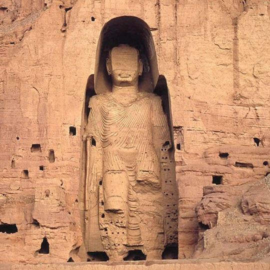
Bamyan
The Bamyan province can be found in central Afghanistan and is famous for its historical sites. Two of which are the Buddhas of Bamyan, the UNESCO world heritage sites displaying Afghanistan’s buddhist heritage. Unfortunately, they were destroyed by the Taliban in 2001.

The Minaret Of Jam
Another World Heritage Site, the minaret of jam is located in western Afghanistan. Also called victory tower, the minaret might have been built to celebrate a victory won by Ghurid Sultan Ghiyas ud-Din. There is speculation that the minaret is one of the last remaining architectural sites of turquoise mountain, a lost city.
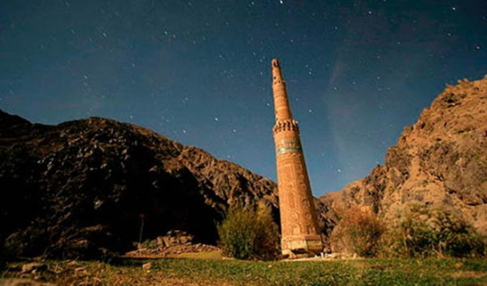
The minaret is currently threatened by erosion and possible floods.
Band-e Amir Lakes
Band-e Amir is the name of a series of 6 lakes in Bamyan. Measuring 6.5 km in length, Band-e Zulfiqar is the largest lake, whereas Band-e Haibat is the deepest. The lakes are seperated by dams of travertine.
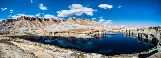
(Band-e Haibat seen above)
(Band-e Zulfiqar seen above)
The Wakhan corridor
The Wakhan Corridor is a strip of land that was once used for trading between Badakhshan (meaning northeastern Afghanistan and southeastern Tajikistan) and Yarkand (a county in northwestern China). However, it is now closed for regular traffic.

The Wakhan corridor is populated by the Wakhi/Khik and Pamiri people.
21 notes
·
View notes
Text
New Post has been published on Trekking in Pakistan
New Post has been published on http://bit.ly/2uOgr8h
Boibar

Duration 3 days Distance 27.4km Standard easy Season Mid-June-September Start/ Finish Jamalabad Zone and Permit open, no permit Public Transport no Summary The beautiful and rarely visited Boibar Valley is the route to Jurjur Khun-e-Sar, Tupodan, Parigar Sar and Qarũn Koh base camps, with Qarũn Pass offering exceptional views of the Hispar Muztagh.
Boibar is an east-west valley whose river descends from Qarũn Koh (7164m) to the Hunza River at Morkhun 10km south of Sost. Boibar is historically significant as the original Wakhi settlement in Gojal and the old route to Shimshal, and has spectacular old-growth juniper trees. Avgarch and Boibar are also names of places in the Wakhan Corridor, suggesting the original inhabitants may have come from Wakhan. Morkhun (2743m) receives more rain than other Gojal villages, as its name suggests (mor means ‘rain’; Khun, ‘house’). At the time of research, villagers were constructing a road to Avgarch with eventual plans to extend it to the Boibar huts.
PLANNING
Maps
The Swiss Foundation for Alpine Research 1:250, 000 orographical map Karakoram (Sheet 1) covers the trek. It labels Jamalabad as Jukulgar, Parigar Sar as Pregar, and the Boibar River at Murkhun. The glacier at the valley’s head labeled Murkhun is locally called Qarũn Koh. Maidun isn’t named, but it’s marked by a triangle.
Guides and Porters
Porters ask for a flat rate per stage, including payment for food rations and the clothing and equipment allowance. Hire a local person to show the way, learn about the area, and support the village’s economy.
GETTING TO/FROM THE TREK
Morkhun is halfway between Afiyatabad and Passu, so jump on any vehicle heading south from Afiyatabad or north from Passu. The short ride on NATCO buses and on vans or wagons. From Morkhun, north of the bridge and south of the Pakistan Army camp, follow the Jamalabad Link Rd half a Kilometre to its end. Jamalabad (2789m), named for the late Mir of Hunza, Mohammad Jamal Khan, lies above the Boibar River’s true right (north) bank.
THE TREK
Day 1 : Jamalabad to Boibar
3½-4½ hours, 7.7km, 716m ascent
Follow the trail east along the canal. A shrine to Shah Shams, marked by white flags, sits on the river’s south side. Reach the first footbridge in 30 minutes and cross to the true left bank. Watch for rock fall between Jamalabad and Avgarch and avoid this section of trail in rain or high winds. Continue along the river’s edge 30 minutes passing scattered rose bushes and the herb spandr to a clear side stream, which flows from Sangar, a scenic grassy ridge descending from Jurjur-Khun-e-Sar (6055m) to the south. (It takes five hours to reach Sangar from Morkhun, making it an eight-to nine-hour round trip).
Just beyond the stream pass Bandiletk. Here red markings on the rock are said to have been made by a bilas (evil spirit) who licked the rock after having eaten people. Villagers say it’s dangerous to travel here after dark. The area on both sides of the river, with its scattered artemisias, ephedras, and roses, is also known as Lalazar (beautiful place in Persian).
Continue 15 minutes to the second footbridge surrounded by tamarisks and a thorny shrub xakh and cross to the river’s true right bank. The trail forks immediately. Both trails lead to Avgarch, but people describe the right fork as dangerous. Take the left fork and follow the trail along the true right bank downstream, backtracking for a few minutes to the base of Yasin Band. Ascend a short 35-degree scree slope, and then a steep, narrow chimney with steps made out of juniper branches, to the terrace above. From this plateau are beautiful views south to Jurjur-Khun-e-Sar and east to Parigar Sar (6200m), a prominent rocky peak (sar) known as the rock (gar) where fairies (pari) dwell.
Continue 30 minutes along a canal at the base of a rocky rhubarb-dotted slope and through level fields and wildflowers to Avgarch (3200m). This large cultivated area was the first settlement of the Wakhi people living in the five villages between Sost and Morkhun who refer to themselves as Avgarchi. It has a mosque with unique wood carvings and two forts. One sits atop the central building, a reminder of the constant battles with Qirghiz people who also used the upper Hunza Valley until the 19th century. A lone giant juniper called Baltar Yarz is nearby. Legend says a boy, Baltar, would have died, but he sacrificed a cow near the juniper tree (yarz) and lived.
From Avgarch, continue up, then cross the river via a footbridge heading south-east to reach Boibar (3505m), a barren summer settlement 1½ hours from Avgarch. Boibar huts sit in a southern side valley, which has a small glacier. Above is the dramatic north face of Tupodan (6106m), whose name means ‘the sun-drenched mountain’.
Day 2 : Boibar to Maidun
2 hours, 6km, 495m ascent
Continue one hour to a cold spring called Xunza Kuk (Queen’s spring), then 30 minutes to Pariyar (the place loved by fairies). These overgrazed pastures are the upper limit of juniper. Many junipers have been cut, but some of those remaining are older than 1000 years. Maidun (4000m), 30 minutes farther, has good water and makes a fine base camp for exploring the upper Boibar Valley. The route to Tupodan Base Camp, used by the 1987 British expedition who were the first to summit Tupodan, heads south up the Tupodan Glacier from Maidun.
Side Trip : Qarũn Pass
4-5 hours, 11km, 873m ascent, 873m descent
The original, but now abandoned, route to Shimshal village followed the Boibar Valley, crossed Qarũn Pass, and descend 2100m of treacherous scree to reach the Shimshal River at Dut. A day trek to the top of the pass offers great views and a glimpse of how difficult access to Shimshal used to be. Legend has it that Mamu Singh, Shimshal’s founder, saw the meadows along the Lupgar Glacier from the pass and so decided to take his livestock there. Shimshalis say the pass is like the legendary miser, Qarũn, because no water is available on the arduous ascent from Dut to the pass, hence the name Qarũn Pass.
From Maidun, ascend 1½ hours past yellow rock outcrops to the pasture of Zardgarben (the base of the yellow rock) from where the pass cairn is visible. Continue, passing right of the Qarũn koh Glacier’s black moraine to the base of the pass (4500m). From this point, the routes to Qarũn Koh and Parigar Sar Base Camps head across the glacier east and north-east respectively. The route to the pass turns south, ascends a scree gully, and traverses to Qarũn Pass (4873m) in one hour. Lupgar Sar, Trivor and Destaghil Sar rise in front. Return from the Pass to Maidun.
Day 3 : Maidun to Jamalabad
4-5 hours, 13.7km, 1211m descent
Retrace steps Downvalley to Jamalabad.
0 notes
Photo


Images of Wakhi people and Kyrgyz people that reside in the harsh environment of the Wakhan Corridor.
Source: Varial Cédric Houin
#afghanistan#afghan#afghan people#afghan man#afghan woman#afghan children#afghan child#asia#asian#central asia#south asia#wakhi#pamiri#kyrgyz#turkic#iranic#life#mountains#rural#poverty#poor#pamir#pamir mountains#karakoram#corridor#wakhan corridor#muslim#islam#traditional#yurt
51 notes
·
View notes
Photo
Photography: Wakhi people, Afghanistan.
Photographer: Silvia Alessi
11 notes
·
View notes
Last Seen Blogs

yoonminkxngs
wiflixstreaming

jointpainfaggot
Staying silly through it all
yoonminkxngs
wiflixstreaming

your-tragic-fairytale-blog
One Day I'll fly away

theseobaba
Seo Baba