#National Scenic Byway
Text


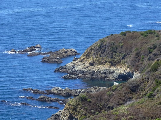


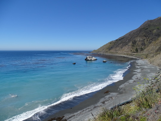
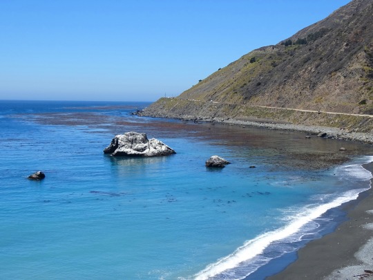
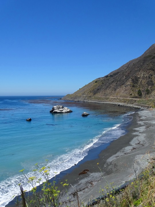
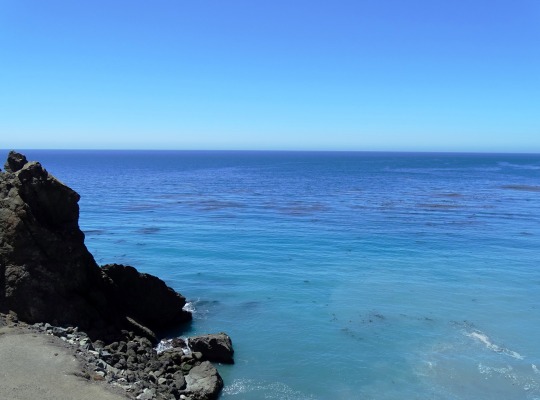
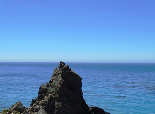
Julia Pfeiffer Burns State Park Vista Point, CA (No. 2)
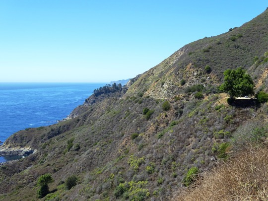
The drive along Highway 1 has been described as "one of the best drives on Earth", and is considered one of the top 10 motorcycle rides in the United States. Highway 1 was named the most popular drive in California in 2014 by the American Automobile Association. Condé Nast Traveler named State Route 1 through Big Sur one of the top 10 world-famous streets, comparable to Broadway in New York City and the Champs-Élysées in Paris. Most of the nearly 7 million tourists who currently visit Big Sur each year never leave Highway 1, because the adjacent Santa Lucia Range is one of the largest roadless coastal areas in the entire United States; Highway 1 and the Nacimiento-Fergusson Road offer the only paved access into and out of the region. In January 2021, the Nacimiento-Fergusson Road was washed out due to the impacts of the Dolan Fire and closed, cutting off the only alternative route out of the area. It is not expected to reopen until December 2023.
The beauty of the scenery along the narrow, two-lane road attracts enormous crowds during summer vacation periods and holiday weekends, and traffic is frequently slow. Visitors have reported to the California Highway Patrol hours-long stop-and-go traffic from Rocky Creek Bridge to Rio Road in Carmel during the Memorial Day weekend. The highway winds along the western flank of the mountains mostly within sight of the Pacific Ocean, varying from near sea level up to a 1,000-foot (300 m) sheer drop to the water. Most of the highway is extremely narrow, with tight curves, steep shoulders and blind turns. The route offers few or no passing lanes and, along some stretches, very few pullouts. The sides are occasionally so steep that the shoulders are virtually non-existent.
Source: Wikipedia
#Julia Pfeiffer Burns State Park Vista Point#Monterey County#California State Route 1#Highway 1#Pacific Coast Highway#National Scenic Byway#Big Sur#Pacific Ocean#travel#original photography#vacation#tourist attraction#landmark#landscape#seascape#countryside#street scene#road trip#summer 2022#California#West Coast#Big Sur Coast Highway#nature#flora#grass#tree#USA#blue sky#blue sea#beach
12 notes
·
View notes
Text
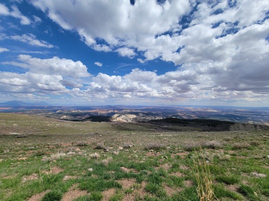
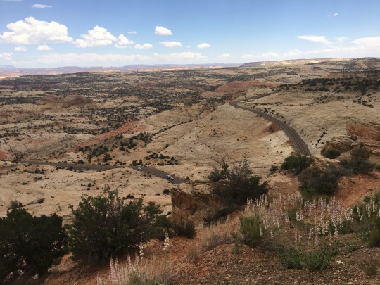
Capitol Reef Overlook - May 23rd 2023
#photographers on tumblr#original phography#nature#american southwest#scenic byway route 12#roadtrip 2023#capitol reef national park#utah#alpine
4 notes
·
View notes
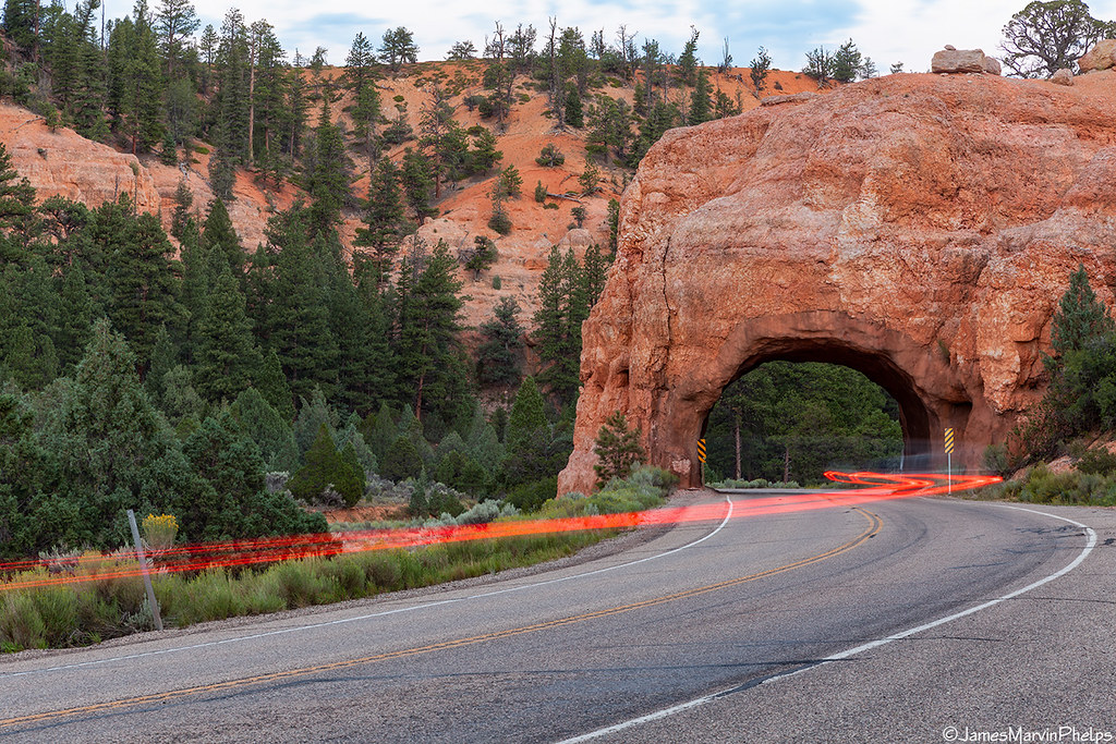
Video

flickr
Light Speed by James Marvin Phelps
Via Flickr:
Light Speed Scenic Byway 12 Red Canyon Dixie National Forest Utah
#Utah#Red Canyon#Dixie National Forest#Travel#Window#Arch#Road#Nature#Landscape#Tunnel#Scenic Byway 12#Traffic#Light Trails#Canyon#Outdoors#James Marvin Phelps Photography#flickr
6 notes
·
View notes
Video
flickr
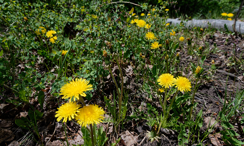
Dandelions in Utah by Mark Stevens
Via Flickr:
A look across a small field of dandelions in Fishlake National Forest. This is at a roadside pullout along Utah Scenic Byway 12. I got down low using the LCD display with LiveView on my Nikon SLR camera to line up and compose this image.
#Aquarius Plateau#Azimuth 282#Blue Skies with Clouds#Canyonlands#Colorado Plateau#Dandelion#Dandelions#Day 3#DxO PhotoLab 5 Edited#Fishlake National Forest#Intermountain West#Landscape - Scenery#Looking NW#Nikon D850#No People#Outside#Partly Cloudy#Project365#Rolling Hillsides#Scenic Byway 12#Scenics - Nature#SnapBridge#Southern Utah and Great Basin National Parks#Spruce Spring#Sunny#Taraxacum#Travel#Wildflower#Wildflowers#Utah
0 notes
Text

National Geographic's Guide to Scenic Highways and Byways, 2001
Found at my local thrift store
#my library#guide to scenic highways and byways#2001#2000s#national geographic#guide book#maps#map book#scenic route
0 notes
Text

0 notes
Video
Lake Marie, Medicine Bow National Forest, Wyoming
#lake marie#lake#alpine lake#medicine bow#medicine bow national forest#national forest#hiking#nature#outdoors#views#wyoming#alpine#mountains#my photos#weekend trips#snowy range#snowy range scenic byway
0 notes
Text
Talimena Sunset
The sun sets on Arkansas’ Talimena National Scenic Byway near the town of Mena.
View On WordPress
0 notes
Text
13 Places to Visit While Road Tripping Through Southern Utah
For this three day weekend we decided to head to one of our most favorite places to visit, Utah, to explore some of their back country roads. We had no plans except to start near Zion National Park.
May 2022
For this three day weekend we decided to head to one of our most favorite places to visit, Utah, to explore some of their back country roads. We had no plans except to start near Zion National Park. Below you will find our video and all our stops along the way with some amazing scenic drives.
Eddie World
Our trips down the 15 always start at the Eddie World right outside of Barstow…

View On WordPress
#beaver canyon scenic byway#beaver river#beaver tacos#brown trout#Caves#creamery in beaver#cutthroat#disperse camping#dixie national forest#duck creek ice cave#duck creek village#Eddie world#enterprise reservoir#fish lake#fish lake national park#fish lake scenic byway#fish utah#fishing utah#FishLake national park#FishLake scenic byway#ice caves#kolob reservoir#lava caves#mammoth lava cave#mill meadows reservoir#overlanders#Overlanding#puffer lake#rainbow trout#road trip vibes
1 note
·
View note
Text

Molas Pass, elevation 10,910 feet, is a high mountain pass in the San Juan Mountains of western Colorado in the United States. The pass is in the San Juan National Forest. It is traversed by the Million Dollar Highway, U.S. Highway 550 south of Silverton, which is part of the San Juan Skyway Scenic Byway.
195 notes
·
View notes
Text
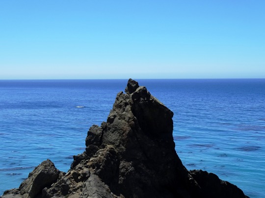

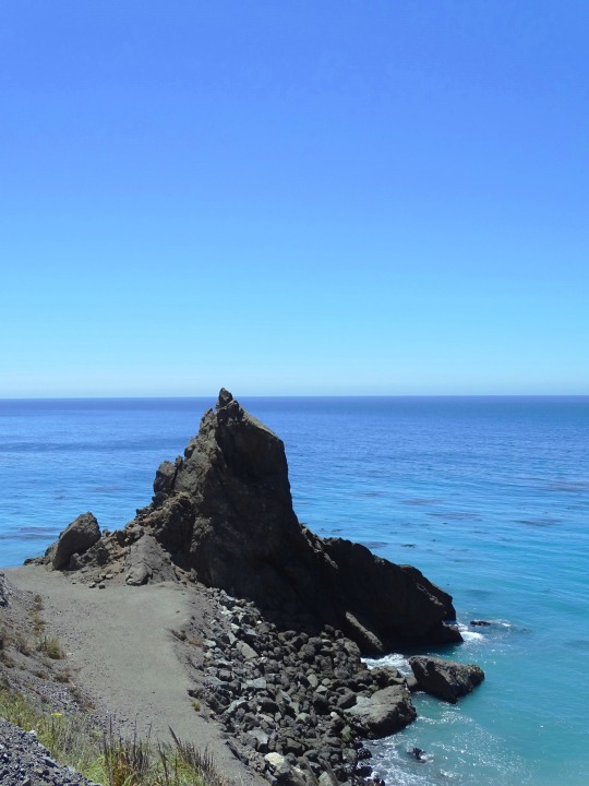

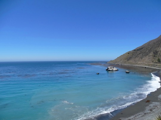
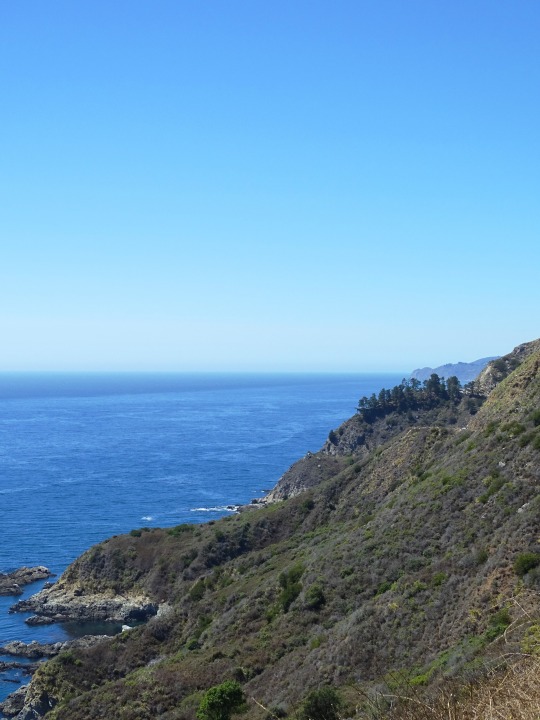
Black Sand Shores, CA (No. 1)
Governor Juan Alvarado granted Rancho San Jose y Sur Chiquito, including the land from Carmel to near Palo Colorado Canyon, to José Castro in about 1848. Castro documented a trail from Monterey to Palo Colorado Canyon used by Native Americans when he filed a map of his purchase in 1853. When the region was first settled by European immigrants in 1853, it was the United States' "last frontier".
After California gained statehood, the trail from Carmel to Mill Creek (present-day Bixby Canyon) was declared a public road by the county in 1855. But the California coast south of Carmel and north of San Simeon remained one of the most remote regions in the state, rivaling at the time nearly any other region in the United States for its difficult access. It remained largely an untouched wilderness until early in the twentieth century.
Yankee businessman Charles Henry Bixby bought several hundred acres south of Mill Creek and harvested lumber, tanbark, and lime. Without a road, he resorted to using a landing chute and hoist to transfer the goods to steamers anchored offshore.
Bixby tried to persuade the county to build a road to Bixby Creek, but they refused, replying that "no one would want to live there". In 1870, Bixby and his father hired men to improve the track and constructed the first wagon road including 23 bridges from the Carmel Mission to Bixby Creek.
Further south, the Rancho El Sur grant extended from the mouth of Little Sur River inland about 2.5 miles (4.0 km) over the coastal mountains and south along the coast past the mouth of the Big Sur River to Cooper's Point. It was largely a cattle operation. There was a brief industrial boom in the late 19th century, but the early decades of the twentieth century passed with few changes, and Big Sur remained a nearly inaccessible wilderness.
Source: Wikipedia
#Black Sand Shores#California State Route 1#Highway 1#Pacific Coast Highway#National Scenic Byway#Big Sur#Pacific Ocean#travel#original photography#vacation#tourist attraction#landmark#landscape#seascape#countryside#street scene#road trip#summer 2022#California#West Coast#Big Sur Coast Highway#nature#flora#grass#tree#USA#blue sky#blue sea#beach#waves
10 notes
·
View notes
Text

Scenic Byway 12, Grand Staircase-Escalante National Monument, UT
June 2023
#rocks#geology#deserts#utah#nature#landscape#photography#landscape photography#nature photography#original photography#photographers on tumblr#lensblr#my pics
65 notes
·
View notes
Video
flickr
Scenic Byway 12 by James Marvin Phelps
Via Flickr:
Scenic Byway 12 Red Canyon Dixie National Forest Utah
#Utah#Red Canyon#Dixie National Forest#Travel#Window#Arch#Road#Nature#Landscape#Tunnel#Scenic Byway 12#Traffic#Light Trails#Canyon#Outdoors#James Marvin Phelps Photography#flickr
1 note
·
View note
Text
The High Road to Taos is one of New Mexico’s most popular scenic byways. The variety of landscapes is a glorious smorgasbord of northern New Mexico’s natural assets. It is one of eight National scenic byways in New Mexico.
#New Mexico#NewMexico#travel#roadtrip#vacation#scenic#nature#history#road trip#weekend getaway#Opt Outside
7 notes
·
View notes
Text

The #Kancamagus Highway is a 34.5 mile drive Scenic Drive in Northern #NewHampshire designated as a National Scenic Byway. It connects to the #WhiteMountains Trail to make a loop and is especially beautiful in the Fall! https://bit.ly/3Svkhj5
4 notes
·
View notes

Last Seen Blogs

enchantingtastemakerfani
제목 없음

julieandrewthings-blog
The Barnstable Painters

kaidouhottopicgiftcard
stapler

hgnr22-blog
Untitled

pterodactylichexameter
For You, My Dear, Anything