#historical maps
Text
Random JSTOR Daily articles that looked interesting
#jstor#jstor daily#readings#history#snippets#Black in the USSR#Black Soviets#maps#asian maps#historical maps#murder#autopsy#medical history#chinatown#trans history#the danish girl#linksave
324 notes
·
View notes
Text
Obsessed by the sheer number of sea monsters on this map of Africa that I came across! This is only 1/4 of it, and look at how many the cartographer put in!!! Convinced this expanse of ocean beyond Madagascar was included just so he could put in the sea monsters.
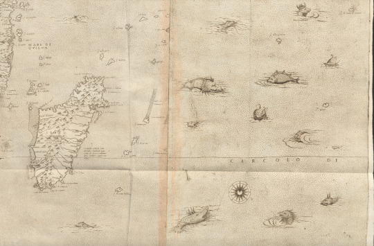
And lots of close-ups, because you need to see them!!!


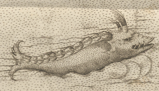
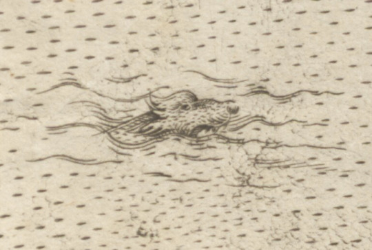

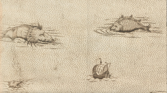
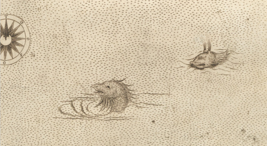
And a link to the source (Il disegno della geografia moderna de tutta la parte dell'Africa, Giacomo Gastaldi, 1564) so you can all have fun seeing them up close and personal too: https://www.digitale-sammlungen.de/en/view/bsb00092152?page=,1
#early modern italy#early modern period#early modern history#sea monster#cartography#early modern cartography#africa#the range of these sea monsters oh my goodness i am losing my mind#giacomo gastaldi#Il disegno della geografia moderna de tutta la parte dell'Africa#maps#old maps#historical maps
64 notes
·
View notes
Photo
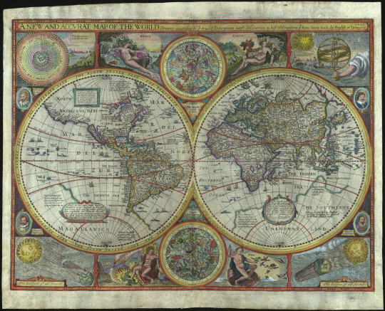
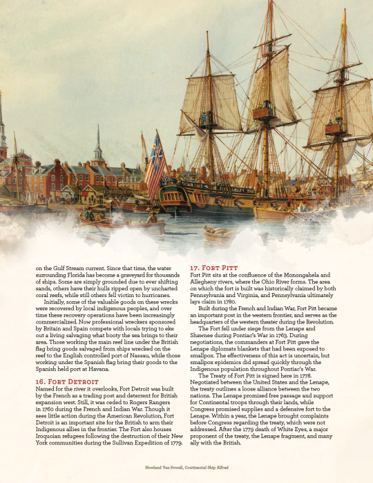
John Speed (1551/52-1629). A New and Accurat Map of the World Drawne according to ye truest Descriptions lastest Discoveries & best observations yt have beene made by English or Strangers. London, 1651.
This map first appeared in A Prospect of the Most Famous Parts of the World, published by George Humble in 1627. George Humble had previously printed Speed’s The Theatre of the Empire of Great Britain, a pioneering work that mapped English counties and maps. The Prospect was a very “English” atlas: it is the first world atlas by an Englishman (though not the first world atlas to be published in England) and does not appear to have circulated much outside of England. It is unclear just how involved Speed was in its production, as he had gone blind in 1625 and the Prospect’s organization in general is not as meticulous as one might otherwise expect from Speed. The map was engraved, possibly by Abraham Goos (fl. 1614-1643), and then hand-colored for sale.
(see more: The World: Science and Art · Places in the World: Treasures from the Venable Collection · Special Collections and Archives)
#mapMonday#maps#map#world map#historical maps#bookhistory#rare books#special collections#mizzou#university of missouri#libraries#john henry#columbia mo
78 notes
·
View notes
Text
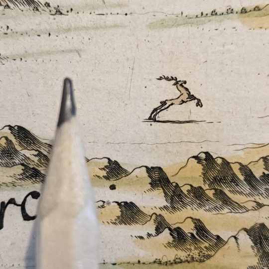
Tiny prancing reindeer, from the map of Norway in volume one of Joan Blaeu's eleven-volume Atlas Major, 1662
18 notes
·
View notes
Text
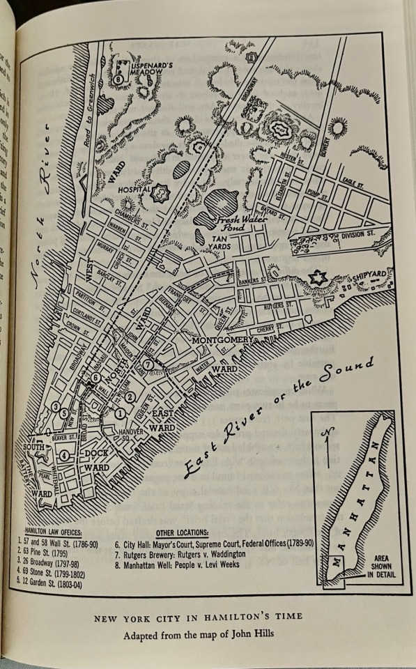
A map of Hamilton’s law offices as seen on page 333 of The Law Practice of Alexander Hamilton: Volume I, edited by Julius Goebel.
This map was a surprise find inside this volume, and a very insightful and helpful one at that. The key also includes other important locations, and years of operation for each office Hamilton held throughout his career.
#alexander hamilton#the law practice of alexander hamilton#historical maps#law history#historical alexander hamilton
43 notes
·
View notes
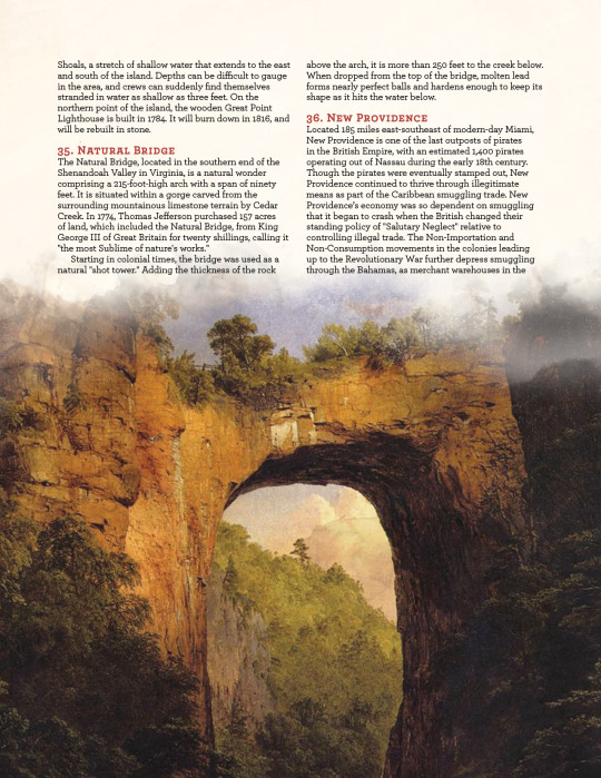
Text
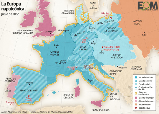
Cool new map of the First French Empire under Napoleon (source)
El mapa de la Europa de Napoleón
#map#mapa#napoleon#napoleonic era#napoleonic#napoleon bonaparte#first french empire#french empire#19th century#france#napoleonic empire#history#Europe#historical maps
12 notes
·
View notes
Photo

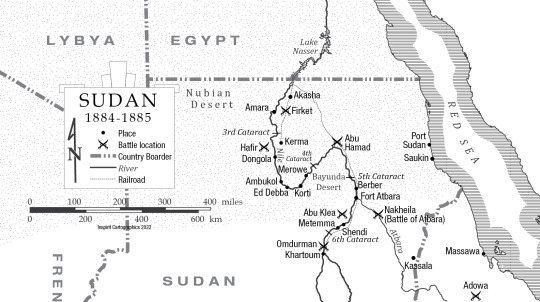
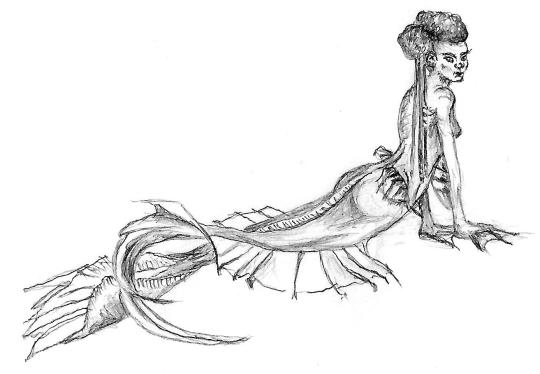
Historical map of Sudan. A mermaid was requested as an embelishment for this one. I didn’t think a disney-like one was very Nile-esque so I came up with this. Fortunetly she was well recieved.
#sudan#historical maps#mermaide#sketch#handdrawn#africa#maps#cartography#custom made#custom maps#Inspirit cartographics
85 notes
·
View notes
Text

Map of Iberia 600 BC: south-western Iberia of around 600 BC contained a rich, technologically-advanced civilisation in the form of the Tartessian culture, as this map shows:
#history#historyfiles#iberia#tartessian#cultures#ancient cultures#pre-roman#maps#historical maps#civilisation#ancient europe
3 notes
·
View notes
Photo


North America, 1776: an Annotated Atlas for Historical Adventures
This map of North America (made by a surveyor in 1777) includes the rebellious Thirteen Colonies, the loyalist Canadian territories of Rupert's Land, Quebec, Labrador, Newfoundland, and Nova Scotia, the Ohio Country and indigenous lands over the Appalachian Mountains, and British holdings in East and West Florida, the Bahamas, and Bermuda.
Original map titled "A new map of the British colonies in North America, shewing the seat of the present war, taken from the best surveys, compared with and improved from manuscripts of several noblemen and gentlemen," created by John Andrews. Annotations and rollable tables were made by the Flagbearer Games team, mixing general information and story hooks + specific details on points of interest.
---
Nations & Cannons is a D&D campaign setting for 18th Century adventures! Straight from the pages of history, our ruleset offers new backgrounds, feats, and character options for living and fighting in the Age of Revolutions. This project will always be accessible for educators, so our quickstart rules are free to download.
If you want more 18th Century and American Revolution content, join our Discord server. Our Kickstarter is live for The American Crisis, a full Revolutionary War sourcebook and adventure campaign covering the war in the north from the Siege of Boston to Valley Forge, the Continental Army’s darkest hour (1775-1778). You can check it out here!
#revwar#revolutionary war#US history#american history#history#american revolution#amrev#colonial#18th century#dungeons and dragons#dnd#d&d#ttrpg#homebrew#5e#historical maps#map
7 notes
·
View notes
Text
3 notes
·
View notes
Text

Territorial evolution of the Byzantine/Eastern Roman Empire. Original Post:
3 notes
·
View notes
Text
Eratosthenes' wobbly Alexandria meridian
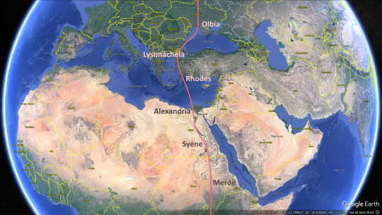
In the mid-200s BCE Eratosthenes invented the device of lines of longitude and latitude. The Alexandria meridian held a central place in his Geography, an account of the geography of the known world.
Key locations on the meridian: Olbia (Ukraine), Lysimacheia (Türkiye), Rhodes (Greece), Alexandria (Egypt), Syene (Egypt), Meroë (Sudan).
Ancient geographers were aware that their meridians weren't perfectly straight. But measuring longitude was a difficult problem, and it wasn't properly solved until the 1700s.
Eratosthenes went on to use published reports of gnomon readings from three of these locations, and a traditional measure of the length of Egypt, to determine the earth's polar circumference. His result was 250,000 stadia -- ca. 46,220 km, plus or minus 2000 km (the stadion isn't a very precise measure). The true figure is 40,008 km.
2 notes
·
View notes
Photo
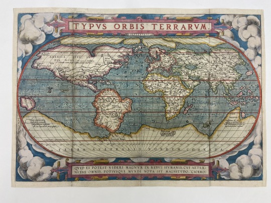
Monstrous Whales! Can you spot them?
The Typus Orbis Terrarum, “The Plan of the World’s Lands,” was the first world map to be published in a ‘modern’ standard atlas by Abraham Ortelius and engraved by Frans Hogenberg in 1570. First published in Abraham Ortelius’s atlas, Theatrum Orbis Terrarum, it was one of the few maps included in the atlas that was created by Ortelius himself.
Learn more (and see the whales up close) in Monstrous Whales · The Art of Cartography: Cartes-à-figures, a digital exhibition curated by Lily McEwen.
#maps#historical maps#map Monday#ortelius#special collections#rare books#university of missouri#libraries#columbia mo#mizzou
23 notes
·
View notes
Text
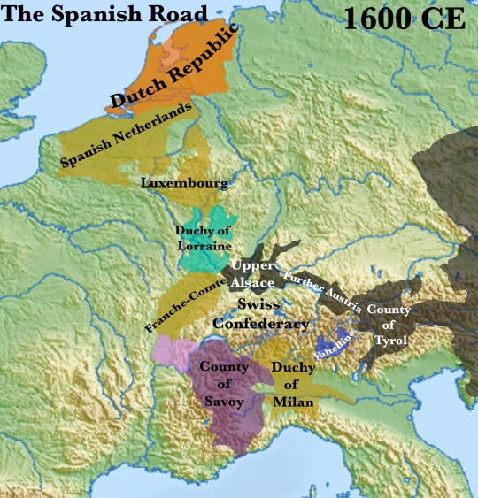
The so-called Spanish Road was a route that linked the Duchy of Milan to the Spanish Netherlands in the 16th and 17th centuries.
When Philip II of Spain began imposing Counter-Reformation policies in his massive domains, there was little issue in most of his lands. This was not the case in the Netherlands. In 1568, the majority-Calvinist provinces rose in revolt, triggering the Eighty-Years War.
Philip was immediately faced with a problem: how to get his armies to the Low Countries? Transporting them by sea inevitably involved running a gauntlet of hostile French, English and Dutch fleets. The risks were unacceptable.
The only solution was to go overland. Fortunately, Philip had also received the Counties of Franche-Comte and Luxembourg as well as the Duchy of Milan. After securing alliances with the Count of Savoy and the Duke of Lorraine, the Spanish now had a means of marching the roughly 1000km from Italy to the Netherlands entirely within friendly territory.
A 10,000-man Spanish army made the journey for the first time in 1567. This force became the Army of Flanders, a permanent standing army that was widely considered the most formidable fighting force in Western Europe for the first 80 or so years of its existence. By 1574, it had swelled to 86,000 men.
The Spanish Road thus became a crucial artery down with men, material and most importantly money flowed to the Spanish Netherlands.
However, the French were determined to sever this connection. Savoy was defeated by France in a brief conflict in 1600-1601 and was forced to cede the provinces of Bugey and Bresse in the north on the border of Franche-Comte. This cut the Spanish Road for the first time.
The Spanish were forced to search for an alternative. They found it in the Stelvio Pass, northeast of Milan. After traversing the pass, Spanish troops could march through the allied Austrian Habsburg domains of the Tyrol, Further Austria and Upper Alsace to reach Franche-Comte.
To reach the Stelvio Pass, any army had to march through the Valtelline, an alpine valley that now became perhaps the most strategically important region in Europe.
This importance only increased with the outbreak of the Thirty Years War in 1619.
Annexed by Spain in 1620, Spanish troops, supplies and money flowed down the Spanish Road anew.
When France finally entered the Thirty Years War in 1635, a French force was despatched to contest Spanish control of the Valtelline. Another French army managed to defeat the Austrians at Breisach in 1638 and permananty annexed Upper Alsace. Thus the Spanish Road was severed in two places. It was never reconstituted.
The subsequent decisive failure of Spanish efforts to reinforce the Army of Flanders by sea was a major factor in bringing the Eighty Years War to an end in 1648, highlighting the importance of the Spanish Road..
Between its establishment in 1567 and its final blocking in 1633, roughly 123,000 had made the long journey along the Spanish Road to the Netherlands.
4 notes
·
View notes
Text
It’s dawned on me today after hours of playing Find Alexander Hamilton On the Map with a lot of slightly disorganized extant and now-lost documents that if I had the skill I would absolutely make one of those interactive animated maps (like this one that shows you troop movements during the American Revolution on any given day of the war!!) so I could both have a visual aid but also so my silly brain who doesn’t know how geography works can stop going “Where is X in relation to Y???” every five minutes.
So like if anyone knows how to make such a thing I’ll forever be in your debt.
#outlining this hamilton series makes me want to pull my hair out#alexander hamilton#amrev#The American Icarus#writers on tumblr#historical fiction#historical research#historical maps#historical alexander hamilton#american revolution#writing struggles#amwriting#writing community#american history
3 notes
·
View notes
Text
George Spong's death - an alternate theory...
At the end of my last post, A death out of place, I mentioned that my cousin, Steve, and I had an alternate theory about the identity of Mary Ann Chapman. Independently we had considered that she might have been hired to care for him after we both found a woman by that name in the 1861 Census whose occupation was recorded as “nurse”1.
Mary Ann (age 25; line: 17; birthplace: Margate, Kent)…
View On WordPress
#collateral research#Family history mystery#genealogy work#heritage#historical maps#lineage#methodology#newspaper research#Spong family
0 notes
Last Seen Blogs

berar0
Без названия

mjbear130
mj's dumpster fire

deblaterate
Noelle

likehighheelspantyhose
Pantyhose Highheels Dominant Females