#cold satellite
Note
hi! can i request a web weave for when you love your partner and the feelings are mutual but you know you’re not meant to be? like when it’s an already existing relationship and everything’s good but you just know it’s not gonna result in marriage and getting old together. please and thank you!


i hope you're doing well <33
Homer The Iliad / Lisa Olstein Cold Satellite; Little Stranger / boygenius Bite the Hand / Sarah Kay & Phil Kaye When Love Arrives / @/ratsandlilies.art (on instagram) / pinterest / Anne Carson Glass, Irony and God / @/ratsandlilies.art (on instagram) / Ross Gay Catalog of Unabashed Gratitude
#on love#on heartbreak#web weave#web weaving#on loneliness#poetry compilation#poetry parallels#homer#the iliad#lisa olstein#cold satellite#little stranger#boygenius#bite the hand#sarah kay#phil kaye#when love arrives#anne carson#glass irony and god#ross gay#catalog of unabashed gratitude#writing#poem#spilled poetry#spilled thoughts#spilled ink#dark academia#dark academia poetry#words#dark academia quote
372 notes
·
View notes
Text
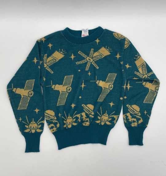
Children's jumper. 1970s.
Atomic age, space race themes.
Peterburg Auctions
12K notes
·
View notes
Text

November 1955 cover
Artist: Wally Wood
Mad Logo Art: Harvey Kurtzman
Border Art: Will Elder
#Mad magazine#vintage cover#1950s#Sputnik#Alfred E Neuman#satellite#the cold war#humor in a jugular vein
106 notes
·
View notes
Text

In honor of today 🌑
#duran duran#andy taylor#john taylor#nick rhodes#roger taylor#simon le bon#80s music#new wave#new moon on monday#fire dance through the night#i stayed the cold day#with a lonely satellite
28 notes
·
View notes
Text
Excellent use of old hardware.
9 notes
·
View notes
Text
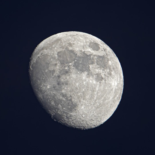
La nuit dernière, 23 décembre 2023.
Cagnes-sur-mer
France 🇫🇷
150-600 Tamron.
#Moon#Lune#Sky#Ciel#Planète#satellite#Cratère#Milky-way#photography#france#cote d'azur#Tamron#Nature#Life#Love#Winter#December#Cold
3 notes
·
View notes
Text

space mouse |2023|
#illustration#space mouse#cold war#reproduction#2023#fan art#pop art#walter lantz#john carey#homage#space race#satellite
3 notes
·
View notes
Note
*grabs you by the ankles and drags you into Ducati land*

#so at approximately 2023 qatar u may pry suzuki from my cold dead hands#its bs bro theres no other team where i actively like both riders AND the bike<///3#suzuki dragged me in in 2020 and now they leave me high and dryy#POOF just like that suzukis gone#GIRL I WAS WAITING ON SATELLITE SUZUKI AND NOW I HAVE NO SUZUKI PERIOD#motogp#joan mir#alex Rins
18 notes
·
View notes
Text

Depeche Mode - Satellite
"Gonna lock myself in a cold black room
Gonna shadow myself in a veil of gloom"
https://youtu.be/OSa9zD09imQ
0 notes
Text
i Need to stop trying to figure out for myself what technologies that are common today would exist in panem during katniss' time and whether theyd be implemented in the victors' houses
#our entire perspective of panem is so shaped by katniss' perspective as a poor person from the/one of the poorest district#are showers and like running water in general common in other districts? what about cars?#would solar panels be on richer houses in district 5? are heaters a thing in some of the richer cold districts?#which tech do regular ppl in district 3 have access to? computers? tvs?#how close to whats normal nowadays is the average kitchen in panem?#idk if music is like. allowed in the other districts but if so then do they have record players? is technology at that point again??#also how does the education system in the different districts function?#like yes we know the capitol is sorta where we are in most technological aspects (sometimes theyre further sometimes theyre behind)#but that doesnt tell us anything abt whats normal in the other districts 😭#like. are fridges common in some richer districts????#we know that telephones and like in ear communication thingies exist but like. does the capitol elite have mobile phones?#how does all of their tv stuff etc work if they apparently havent yet figured out satellites again?#how do they have high-speed trains hovercrafts and fucking forcefields but no high flying planes or cds#they have nuclear weapons and solar panels and whatever tf is necessary to control the arenas#but then they dont have other tech thats normal to us??#now that im thinking abt it this sorta feels like how we dont know how some other societies made their concrete#bc they didnt write it down or whatever but it's stronger than what we're doing nowadays#like this is panem w our tech#we have stuff thats normal to us. shit happens. panem comes into existence. and now they wanna figure out wtf we were doing.#and like again abt the fact that fucking latin has survived and knowledge of a place called rome#what are some other things from like our time that couldve made it until then.#do they know abt bts. has greek survived. do they know about the pyramids. they have to know abt the pyramids. theyre so fucking old.#would they know abt like ikea. is the cultural impact of stuff like apple big enough to still be known 200ish yrs in the future in panem.
0 notes
Text
TBM’s weakest album for me musically is Superstition (not bad just an experiment that didn’t quite work), their weakest album thematically is Fascination (closest thing to a theme is a generic love story from initial enchantment to disillusion), their weakest album overall is Under Your Spell (second-weakest in both categories). It’ll be interesting to see if the next album can compete with Diamonds for biggest comeback
#diamonds was sooooo tight and lacquer-solid. hit after hit of duality in the songs#Alice allusions (a classic)/mirrors. past and future. parallel worlds. girls and boys. ink black and pale blue#fascination—at first I straight up didn’t like it. did nothing for me. then I bought it this year and it has some really good songs!#who could have guessed!#stars and satellites/precious hearts/like fear like love and then the opener and closer all quite good.#and dreams of you is very nearly great. the lyrics are just undercooked for the best tune#annnnywayyyyyy they’re working on the next album and I hope to goodness it’s another diamonds becusss they’re on a bit of a weak streak#Kelsey rambles#I’m liking superstition more in retrospect but under your spell is just Not Good. it’s not a good album. I almost quit them cold turkey#and then of course diamonds released and I went out and bought their entire physical discography in response
1 note
·
View note
Text


Satellite of the USSR. Mechanical clockwork toy. Author of the painting Patvakan Petrosovich Grigoryants. Leningrad: Leningrad Plant of Metal Products, 1960s. Metal, lithography. 11.5×7.7×5.5 cm. In good condition.
Author of the painting P.P. Grigoryants has created dozens of packages for various goods. The most famous envelopes in the USSR were envelopes of razors "Neva", "Ladoga", "Baltika", as well as metal toys produced at LZM "Airport", "Motorcyclist", "Circle Exit", "Sputnik".
Emelyanov, Yu.V. Space toys in the USSR. Moscow: Izvestia, 2019, p. 240-241.
Litfund
22 notes
·
View notes
Link
This episode is brought to you by the support of Dragonball Legends. Download and play for free from the Apple App store or Google Play.
SpaceTime Series 26 Episode 144
*Explaining why galaxies hang out with their own kind
A new study may have solved one of the most perplexing mysteries in astronomy -- why galaxies in our neighbourhood hang out with their own kind.
*NASA’s Cold Atom Lab Sets Stage for Quantum Chemistry in Space
For the first time in space, scientists have produced a quantum gas containing two types of atoms.
*North Korea launches a new spy satellite North Korea claims its successfully launched a new spy satellite.
*The Science Report
Dust storms are increasing dramatically in frequency in Australia.
Study claims the impact of screens on children and show a mix of small risks and benefits. Footprints discovered in Victoria show the amazing diversity of Australia's early bird population. Skeptics guide to the House Oversight Committee on UFOs
Listen to SpaceTime on your favorite podcast app with our universal listen link: https://spacetimewithstuartgary.com/listen and access show links via https://linktr.ee/biteszHQ Additionally, listeners can support the podcast and gain access to bonus content by becoming a SpaceTime crew member through www.bitesz.supercast.com or through premium versions on Spotify and Apple Podcasts. Details on our website at https://spacetimewithstuartgary.com For more SpaceTime and show links: https://linktr.ee/biteszHQ For more podcasts visit our HQ at https://bitesz.com
#space #astronomy #podcast
#astronomy#atom#chemistry#cold#gaaxy#korea#lab#nasa#news#north#pod#podcast#quantum#satellite#science#space#spy
0 notes
Text
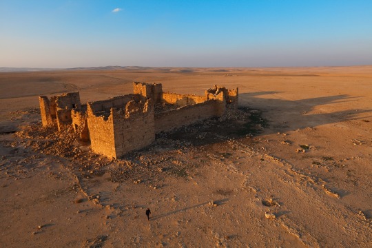
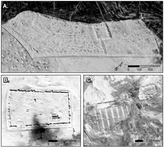
Qasr Bshir is an exceptionally well preserved Roman fort, or castellum, in the Jordanian desert. New research using declassified spy satellite images has revealed the likely traces of nearly 400 previously unknown Roman-era forts across the deserts of Syria and Iraq. Photograph By Robert Clark, National Geographic Image Collection
What Declassified Cold-War Spy Photos Tell Us About Ancient Rome
The Images Challenge Ideas About the Empire’s Eastern Frontier, Based Off Earlier Data Collected From a Biplane.
— By Tom Metcalfe | October 25, 2023
Declassified photographs of the Middle East from Cold-War spy satellites have revealed what may be hundreds of previously unknown Roman forts in the deserts of Syria and Iraq—a discovery that suggests the ancient border between the Romans and their enemies to the east was a place of cultural exchange, not constant warfare.
Until now, researchers knew of the remains of only about 100 forts in the region built by the Roman army mainly in the second and third centuries A.D., thanks to evidence from aerial photographs taken in the 1920s and 1930s by Antoine Poidebard. The priest, pioneering archaeologist and pilot observed that the remains of the forts he viewed from his biplane formed a defensive line running roughly north to south, which he theorized marked a fixed military barrier against raids by Persians and the region’s nomadic tribes.
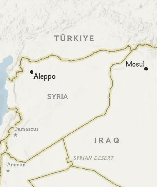
Map of the area
But the declassified photos, taken between 1960 and 1986 by the American CORONA and HEXAGON satellites, reveal nearly 400 additional possible forts, distributed in a pattern that suggests they were used to facilitate caravan trade, troop movements, and communication across the region, rather than simply serving as a means of defense.
“This conception of these forts as demarcating a border between two places is clearly incorrect,” says Jesse Casana, an archaeologist at Dartmouth College and lead author of a Dartmouth study on the spy satellite discoveries and their implications for ancient history, published today in the journal Antiquity.
“They don’t look like wall meant to keep people out," Casana observes. "[T]hey look like they’re placed to facilitate movement.”
Cold-War Spy Satellites
In his landmark 1934 book La trace de Rome dans le désert de Syrie (The Remains of Rome in the Syrian Desert) Father Poidebard identified the sites of 116 Roman forts that he thought lay along the frontier with the Persian state, which was ruled by the Parthians until A.D. 224 and later by the Sasanians. He assumed the forts followed a military road called the Strata Diocletiana (Diocletian’s Road) that had been built across Syria during that emperor’s reign in the late third century.
But Casana says what appeared to be a defensive line is actually a product of discovery bias, and although Poidebard’s pioneering work has been invaluable for generations of archaeologists and historians, it does not reflect the true state of the frontier.
“If he’d flown his biplane everywhere, he would have found a lot more forts—but he didn’t have the capability or the technology to do that at the time,” Casana notes.
That technology didn’t arrive until 1960, when the U.S. began its CORONA spy satellite flights. The program operated until 1972 and consisted of 130 satellites carefully synchronized to take detailed photographs over sites of military interest; another 19 satellites were launched under the HEXAGON program, which ran until 1986. Canisters of film were ejected from the satellites and fell back to Earth, where they were collected in the Pacific Ocean by the U.S. military.
Some canisters were lost; but those that were recovered by USAF aircraft included photographs of the territory covered thirty years earlier by Poidebard, says Casana. The CORONA imagery was declassified in by the U.S. in 1995 and HEXAGON in 2019.
The remains of this Roman fort in Qreiye, Syria, was photographed by pioneering archaeologist and pilot Father Antoine Poidebard from his biplane in 1934. Photograph By Father Antione Poidebard
A Fading Frontier
Those spy satellite photographs captured in the Middle East half a century ago now provide archaeologists with a unique record of how the terrain in the region once looked. Many of the archaeological remains identified in the images have since disappeared with the rapid growth of cities, construction of reservoirs, and scourge of conflict.
There were also significant changes in the few decades between Poidebard’s aerial surveys and the Cold War images: Of the 116 Roman forts identified by biplane, only 38 could be located in the satellite photographs, Casana says.
Those 38 forts, however, enabled the researchers at Dartmouth College to fix a baseline from Poidebard’s survey. They then manually scanned more than 2,000 photographs from the satellites and identified more than 10,000 possible archaeological sites across a 300,000 square-mile area; these were then winnowed down to just 396 sites that were likely Roman forts, based on rules for size and shape established by Poidebard. Many are square and between 160 and 330 feet long on each side, but some are much larger.
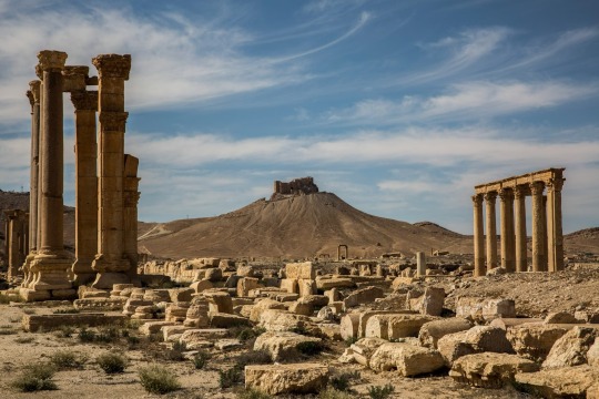
The ancient city of Palmyra was located along the Strata Diocletiana, a military road built by Emperor Diocletian in the 3rd century A.D. It was once believed that Roman forts followed the Strata Diocletiana in a static, north-south line of defense against enemies from the east. Photograph By Bryan Denton/The New York Times/Redux
The new distribution of forts is very different than that seen by Poidebard, who described a line of structures along the Strata Diocletiana extending from Damascus and Bosra in Syria’s south-west to Nisibis (modern Nusaybin) on the Turkish border.
Casana’s team have identified forts far to the east of the Strata Diocletiana, near the Iraqi city of Mosul on the Tigris River; far to the west, around the Syrian city of Aleppo; and notably in the west of Syria’s Jazira region, an extremely arid region with few sources of surface water. Instead of a fixed frontier facing east, many of the forts seem to form networks between western Syria and the Tigris River, which suggests to Casana they supported trading caravans and communications across the region, as well as defensive military functions.
“The distribution was a real shock,” Casana says. “I had grown up thinking the forts formed a line on the border—but they don’t.”
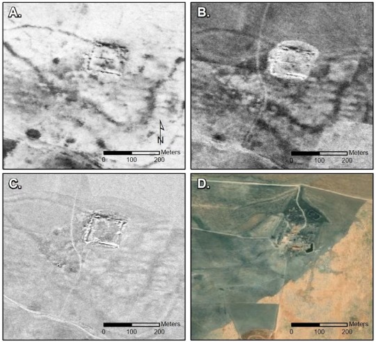
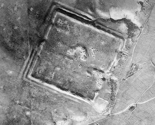
Left: Declassified CORONA spy satellite images include known Roman fort sites at Sura (A) and Resafa (B) in Syria and Ain Sinu (C) in northern Iraq. Image Courtesy Corona, US Geological Survey
Right: The Roman fort at Tell Brak, Syria, as captured in a 1967 CORONA image (A), a 1968 CORONA image (B), a 1974 HEXAGON image (C), and in modern satellite imagery (D). Image By Sri and Maxar Technologies Courtesy Corona/Hexagon, US Geological Survey

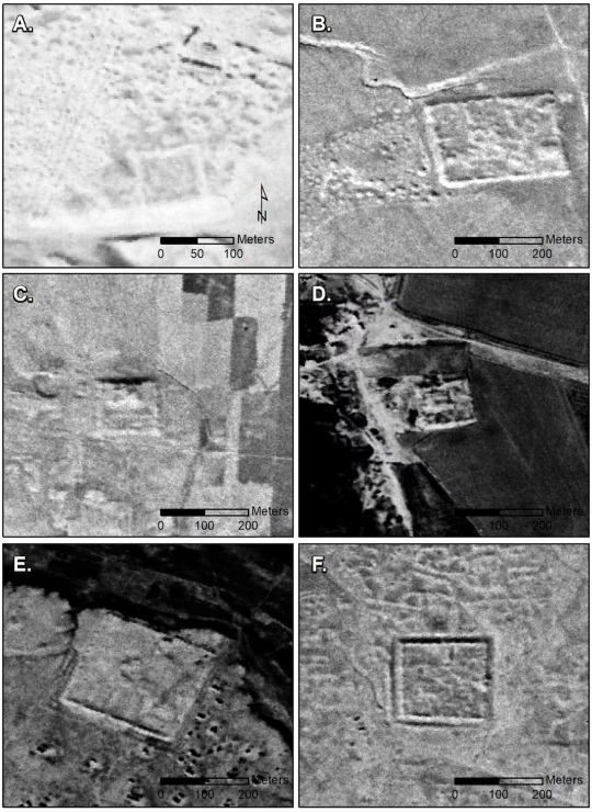
Left: A sample of newly identified Roman fort sites in Syria and Iraq revealed by CORONA spy satellite imagery. Image Courtesy Corona, US Geological Survey
Right: In the 1920s and 30s, pioneering aerial photographer Father Poidebard collected evidence for 116 Roman forts across Syria and Iraq like the examples above; only 38 of Poidebard's sites could be identified in spy satellite photos from decades later. Image Courtesy Corona, US Geological Survey
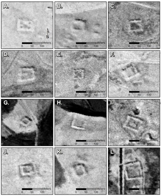
An example of small Roman-era forts captured by Poidebard. The pioneering archaeologist established rules on how to identify these military buildings based on shape and size. Image Courtesy Corona, US Geological Survey
Edge of an Empire
The newly discovered forts provide increasing evidence for the theory that Rome’s eastern border—once seen as a static, fortified barrier against Persian and nomad raids—was instead a dynamic region with different forts occupied at different times, and trading caravans frequently crossing the region in both directions.
Archaeologist Rocco Palermo of Bryn Mawr College, who wasn’t involved in the study, says spy satellite photos have become a vital resource for researchers and their detailed examination is a crucial advance.
“This study applies a new technique to assess the distribution of forts, and proves that it followed complex dynamics like trade,” he says.
Palermo explains that Rome’s eastern border was unlike its others, where the empire faced only “barbarians” on the other side. But in the east Rome faced the Persians, an organized empire with a well-trained army. The border region was further “buffered” by nomadic tribespeople, who often acted as go-betweens for the major powers, he says.
“This was a complex and environmentally fragile region, where the nomadic tribes were an integral part of trade and cultural encounters,” Palermo adds.
Some of the newly discovered sites have been earmarked for future archaeological investigations on the ground, but others lie in active military zones off-limits to researchers.
Archaeologist Lidewijde de Jong at the University of Groningen in the Netherlands, who also wasn’t involved in the study, says the research also illustrates the enormous potential of aerial photography and satellite imagery for the study of ancient landscapes.
The study “focuses on a region where opportunities for archaeological excavations are limited,” whether due to political instability, modern development of the landscape, or economic crises, she notes.
#Ancient Rome | Italy 🇮🇹#Cold War | Spy Photos#De-Classified#Tom Metcalfe#National Geographic#Spy Satellites
0 notes
Text
please bring back 2014 indie pop (i could care less that a few of these songs were pre or post the 2014 era if the song fits it fits)
cecelia and the satellite by andrew mcmahon in the wilderness
i wanna get better by bleachers
cigarette daydreams by cage the elephant
ways to go by grouplove
girls by the 1975
miracle mile by cold war kids
take a walk by passion pit
little talks by of monsters and men
tongue tied by grouplove
midnight city by m83
undercover martyn by two door cinema club
i can talk by two door cinema club
young blood by the naked and famous
kids by mgmt
1901 by phoenix
young folks by peter bjorn and john
daylight by matt & kim
animal by neon trees
stolen dance by milky chance
out of my league by fitz and the tantrums
talk too much by coin
greek tragedy by the wombats
chocolate by the 1975
anna sun by walk the moon
everybody talks by neon trees
what you know by two door cinema club
dancing on glass by st lucia
FEEL FREE TO READ THE PART AT THE TOP WHERE I SAY ITS NOT ALL FROM 2014 THANKS!
#indie pop#2014#2013#spotify playlist#playlist#music#the 1975#matty healy#coin#the wombats#tumblr#indie#bleachers#jack antonoff#cage the elephant#mgmt#grouplove#walk the moon#tumblr era#two door cinema club#st lucia#neon trees#milky chance#phoenix#matt and kim#peter bjorn and john#the naked and famous#m83#coming of age#cte
68K notes
·
View notes
Text
And now the yes men are ready to pass climate lockdowns
#satellites give true air temp not "#urban heat #island"
hot in some #places not in others
#cold kills more than heat
they #overstate the effect so you downplay the #cost
#OneHealth'll grant #WHO(#BillGates its biggest funder)to impose climate #lockdowns
https://salvatoremercogliano.blogspot.com/2023/08/and-now-yes-men-are-ready-to-pass.html?spref=tw
#urban heat island#satellites#places#cold kills#overstate#downplay#one health#who#bill gates#climate lockdowns
0 notes
Last Seen Blogs

digitaleducationworld-blog
Education is now

fairytailuniverse
Fairy Tail Universe

pan69null
dirty experience

vs-blue
SUCK IT Reds

ailinu
Here And Now We Are Alive