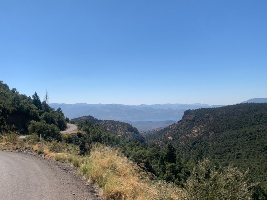
#cottonwood peak
Photo

Wulsten Baldy
Acrylic on canvas 8x8".
Charles Morgenstern, 2023.
The Sangre de Cristo Mountains seen from Coaldale, Colorado.
#colorado#landscape#mountains#artwork#painting#illustration#wulsten baldy#sangre de cristo mountains#coaldale#eagle peak#cottonwood peak#arkansas river valley#acrylic#drawing#design#realism#impressionism#art#artists on tumblr#illustrators on tumblr#tetramodal#charles morgenstern#clouds#travel#nature#outdoors#wilderness#forest#environment#southwest
25 notes
·
View notes
Photo

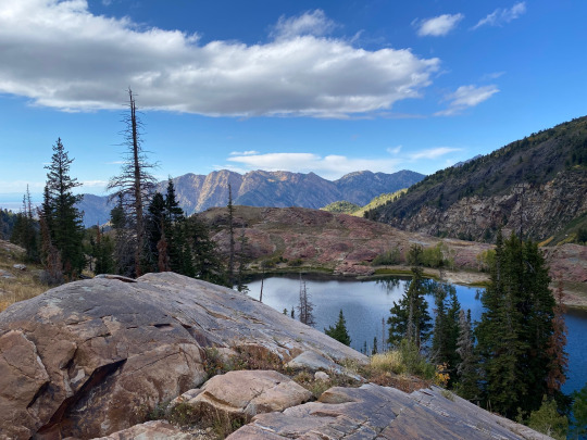


Sundial Peak - lake Blanche
10.1 miles roundtrip
4,186 feet elevation gain
Link: https://www.alltrails.com/trail/us/utah/sundial-peak-via-lake-blanche-trail
It had been a while since I’d done some solo adventuring, so I decided to spend the night at Lake Blanche and scratch my explorer’s itch. I’d been there a few times and wanted to check out Sundial Peak, the eye-catching mountain that overlooks the lake. I had done some research beforehand about paths to the top, and I my interest was piqued by the fact that there wasn’t actually a trail to get up there. I’d have the freedom to pick my own path to the top, and hopefully the wisdom and ability to do it safely.
I headed out in the afternoon and hauled ass up the mountain. Fun fact: this was my first time ever using my hiking poles after having owned them for about 2 years. I can confirm that they may have helped a bit.
After quickly setting up camp on the quiet side of the lake, I set my eyes on Sundial Peak and set out. Now, the real reason I was doing this hike was to film my Survivor application on the way up, but this is a hiking blog so I won’t talk much about that…
The climb up to Sundial Peak was a true adventure and everything I hoped it would be. I navigated, I climbed steep faces, I made a few reckless decisions but vetoed far more of them. I felt like a true mountain man calling on all of my skills and experience to get to the top. And you know what? It was fucking awesome. I got to the summit and got to look down at the lake and see my tiny campsite, and I just took some time to drink it all in. My itch was scratched.
The descent from the summit was a story of impeccable risk management, where I ended up taking a ton of detours from my ascent. A younger version of me would have chosen the quickest route down, but the current version of me (with a fully formed frontal lobe) was worried about getting home safely to my girlfriend.
After a surprisingly short amount of time, I finally made it back to my campsite. The sun was starting to set so I quickly heated up some water for dinner, wolfed down my MRE, and cozied up in my sleeping bag to finish my book.
My night wasn’t as restful as I anticipated, as I spent a large majority of the night growling at animals outside of my tent. At one point I made the bold move to open my tent and finally face the beasts that had been terrorizing me all night, only to find nothing there. Mother nature sure has a way of messing with you.
I woke up before the sun for a cold hike back to the car, and enjoyed some more of the peace and quiet before returning to civilization. What a trip.
If you haven’t gone solo camping before, I can’t recommend it enough. It’s hard and it’s scary and it’s certainly dangerous, but man is it rewarding.
#hiking#backpacking#camping#utah#wilderness#lake blanche#sundial peak#big cottonwood canyon#wasatch mountains#wasatch
4 notes
·
View notes
Text
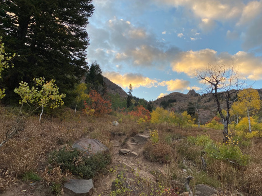
Mid Morning Light...
highlighting weeds, elms & cottonwoods on the North side of Willow Lake Road. We are within a few days of peak Autumn color around Willow Lake.
#willow lake#autumn#original photography#photographers on tumblr#bkpic#landscape#canon 90d#sigma lens
21 notes
·
View notes
Text
Science Saturday: How to make Limestone
Limestone is a type of sedimentary rock made by chemical processes (dare I say, a chemical sedimentary rock) rather than physical processes (what we call a clastic sedimentary rock).
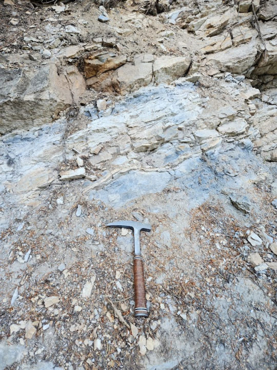
Limestone in Big Cottonwood Canyon, Utah with my hammer for scale.
Limestone is primarily composed of the mineral calcite or aragonite which precipitate out of water containing dissolved calcium ions.
(CaCO3) Calcite and aragonite chemical formula
This can happen through both biologic and non-biologic processes. About 20-25% of all sedimentary rocks are carbonates and most of those carbonates are limestone. The remaining carbonates are mostly dolomite (or dolostone to avoid confusion with the mineral dolomite) which differs from limestone due to it's high magnesium content.
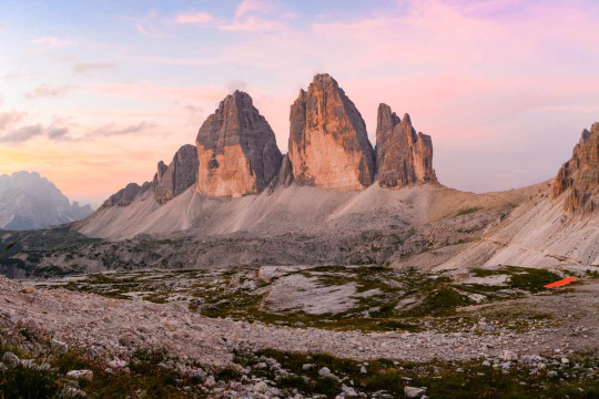
Dolomite Peaks, Italy
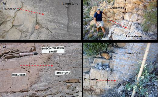
In fact, physically, you can't tell dolomite and limestone apart (at least not to my knowledge, I work in clastic sedimentary rocks so if you're reading this and you work in carbonates, feel free to chip in), usually just lump all carbonates I see as limestone. Technically, there are few things you can test physically but you absolutely need the right tools. Dolomite is slightly harder than limestone and does not as readily dissolve in HCl (fizzes less). Sometimes you can see a change but often they are just too similar to tell in my experience.
Limestone is commonly gray to white though iron or managnese can make it yellow, or red and high organic content can make it almost black.
Gray limestone in Provo Canyon, Utah
Red stained yellow limestone in Timpanogos Canyon, Utah
But how is limestone formed? One way is through biochemical processes. Many marine organisms have learned to precipitate a calcium carbonate shell. When these organisms die, they fall to the sea floor. Eventually, they are turned into bioclastic limestone with chemically precipitated calcite cement between them.
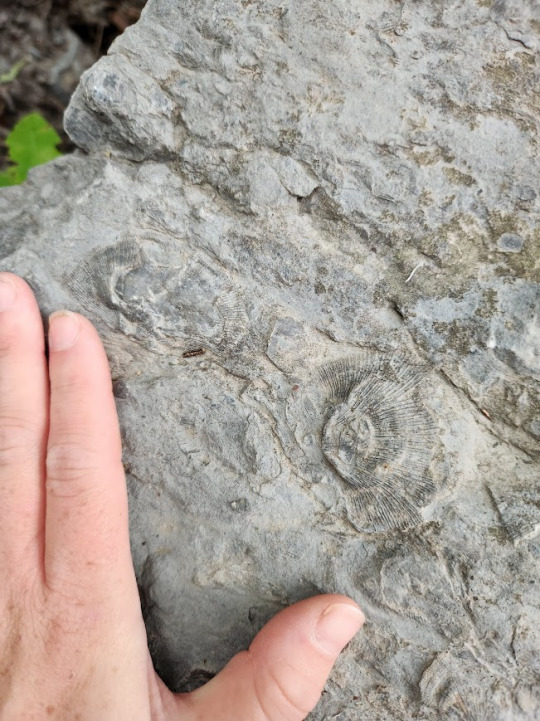
bioclastic limestone, Provo Canyon. Brachiopod shells with my hand for comparison.
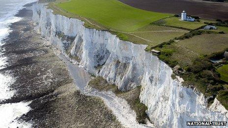
One type of bioclastic limestone is finely-grained chalk like the White Cliffs of Dover which formed from coccoliths. Chalk can be formed from algae, foraminifera and plankton. It is very soft, porous version of limestone.
Limestone can also form chemically, precipitating straight out of the water as such: H2O + 3CO2 -> CaCO3.
And now you know the basic ways to make limestone.
12 notes
·
View notes
Text
train today: fat grasshoppers, cottonwoods and willow all gold, the rabbitbrush just starting to fade off from their yellows, desert plum and wild rose in red red red. sedges going burnt umber and redbrown. scrub oak throwing acorns everywhere this year. magpie! even the russian olive are pretty, whitesilver among the reeds. fields of spent horsethistle like interlocking skeletons. above, the mountain big and solid and skyward, dressed in her reds of maple and oak, the faintest little snow on the peak today. and beyond it all the sky blue blue blue blue
16 notes
·
View notes
Photo

Where I walked.
South Fork Road, Cave Creek Canyon, Coronado National Forest, Cochise County, Arizona.
On the peaks fall colors already dominate, but at lower elevations the sycamores and cottonwoods are just starting to turn from green to gold.
#photographers on tumblr#landscape#fall colors#Cave Creek#South Fork Road#Chiricahua Mountains#Coronado National Forest#Cochise County#Arizona
79 notes
·
View notes
Text
hiking goals for 2023
climb 300,000 feet of elevation somewhere between 207,257 - 222,161
hike at least once per month
hike grandeur at least once per month
more trail running
multiple 10k days (at least 2)
donate 1% of the vert I do in June to the Trevor Project
routes to choose from:
Timpanogos Sampler Out and Back
Timpooneke Trailhead -> Summit -> Aspen Grove Trailhead -> Summit -> Timpooneke Trailhead Attempted
Cottonwood Traverse (10K)
American Fork Twins to the Pfeifferhorn Saddle
Cottonwood Ramble Route (at least AF Twins to Big Cottonwood via South Ridge of Superior, maybe all the way to Millcreek) (10K, depending)
Beatout exit via The Notch
Box Elder Figure 8 (10K)
Kings Peak in a Day
South Ridge of Superior with Sabrina and Maia
West Slabs with Sabrina and Maia
The House to Park City (via Neff’s Canyon to Desolation Trail to Random Park City Trails) Different trails taken
Rainier
Backpack Gannett
Backpack the Teton Crest Trail Trail Run, not whole TCT
Nebo with the Gals
Sundial Peak
Timpanogos Traverse
North Timp -> Timp -> South Timp
Cardiac Ridge Traverse
Superior -> Kessler (Northbound)
Cardiac Ridge + Superior via the South Ridge Linkup
Monte Cristo via Mill B South Fork (Lake Blanche Trail)
Cardiff Pass to Red Pine Lake Trail
Wildcat Ridge Traverse
Olympus via North Face
Olympus Double Feature
Olympus + Grandeur Peak via West Face
Olympus + Grandeur Peak via West Face + Kessler
Cowboy Scramble lol
Trail run down the Desolation Trail?
Whitney Mountaineer’s Route Attempted
Backpack to Lake Blanche? White Pine? Red Pine? With frands
Backpack in Great Basin
#hiking#goals#nyr#new year's resolution#new years resolution#new year's resolutions#new years resolutions#traverses#to do#traverse#2023
23 notes
·
View notes
Text
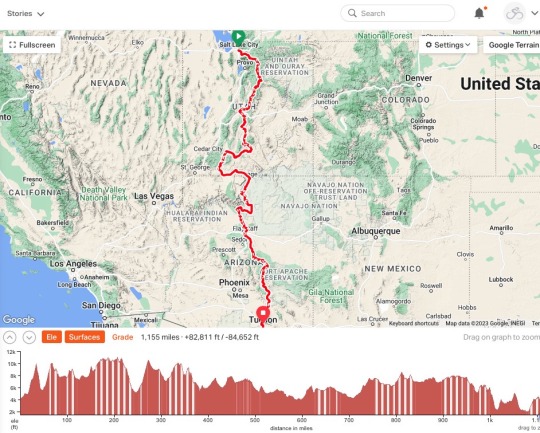
Salt Lake City to Tucson
22 September - 13 October 2023

My last post was on September 14th, just before I headed to Salt Lake City to start my long-anticipated ride to Tucson. Since then I’ve had an amazing three-week adventure on the bike, I’ve had numerous enjoyable rides around Seattle, and I’ve spent hours going through the resulting photos and notes. But I’ve also struggled with my motivation and my interest in maintaining this blog. Regardless of what I end up doing with the blog, I thought it would be good to write up a summary of the recent trip. Whether I flesh out individual days of the ride or whether I continue to post about future rides remains unclear.
======
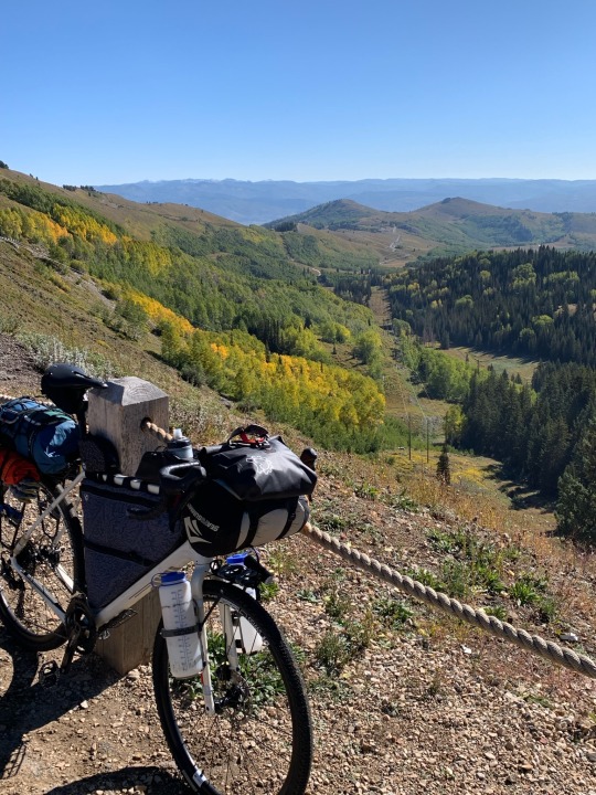
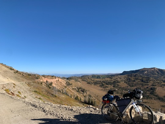
I rode out of Salt Lake City on Friday, September 22nd. I rode into Tucson on Friday, October 13th. Along the way, there were 22 days of amazing landscapes and incredible riding. I traveled around 1150 miles (50+ miles/day, more than 450 of it on gravel roads and dirt tracks. I suspect I walked my bike a total of 4-5 miles on steep or rough segments. There was 83,000’ of climbing, including several sustained climbs of 4-5,000’. Much of the first week was spent climbing to or riding above 10,000’. I camped a little less than half the nights. I never took a full day off, though I considered it in Flagstaff.

Highlights. There were a lot of them. Big Cottonwood Canyon and Guardsman Pass. Skyline Drive on the Wasatch Plateau. The aspens in the valley of Sevenmile Creek. Hell’s Backbone Road. Scenic Route 12 from Boulder to Escalante. Bryce and Red Canyons. Camping at Rock Point on the edge of Marble Canyon. The South Rim of the Grand Canyon. The San Francisco Peaks. The Mogollon Rim and the amazing descent to the Salt River.


The weather was great, except for some rain in southern Utah that required a major detour to avoid muddy roads and added two days to the trip. Temperatures were cold at night, particularly on the Wasatch Plateau, but it was great during the day. Heat was never a problem during the ride itself, though the weekend after I got to Tucson, temperatures rose into the high 90s.
My route evolved over many months of pouring over maps and checking online sources. Some of the territory was familiar to me and that influenced decisions about places I wanted to visit (or felt okay skipping). I wanted to experience as wide a range of landscapes and geologic provinces as I could. I wanted to avoid busy highways, but I also didn’t want a route that was too rough and too remote for my bike or my capabilities (particularly riding solo).
The result was a wonderful mix of roads and trails. Almost 600 miles of my route was on the Western Wildlands Route (courtesy of Bikepacking Roots), a north-south route from Canada to Mexico that parallels, but lies farther west than, the better known Great Divide Mountain Bike Route.
Here’s a list of each day, showing mileages and elevation gain. I may eventually work up descriptions of each day and link them here, but haven’t done so yet. I posted fairly regularly on Instagram (@gravelbeach) and that remains a source of photos and limited narrative.
9-22 Salt Lake City to Brighton 28.4 miles 4122’
9-23 Brighton to Currant Creek Summit 41.8 6634’
9-24 Currant Creek Summit - Scofield 67.6 5012’
9-25 Scofield - Skyline 45.1 5467’
9-26 Skyline - Salina 66.5 3856’
9-27 Salina - Fish Lake 44.2 5748’
9-28 Fish Lake - Posey Lake 54.1 4385’
9-29 Posey Lake - Boulder 23.7 2440’
9-30 Boulder - Cannonville 64.7 4176’
10-1 Cannonville - Hatch 33.1 2342’
10-2 Hatch - Kanab 57.4 2440’
10-3 Kanab - Page 76.8 2449’
10-4 Page - Rock Point 45.4 3348’
10-5 Rock Point - Cameron 65.1 1997’
10-6 Cameron - Grandview 47.6 4519’
10-7 Grandview - Kelly Tank 54.0 2709’
10-8 Kelly Tank - Flagstaff 35.6 2405’
10-9 Flagstaff - Kehl Springs 72.5 3618’
10-10 Kehl Springs - Young 64.9 3459’
10-11 Young - Globe 67.6 6032’
10-12 Globe - Willow Springs 53.7 4172’
10-13 Willow Springs - Tucson 61.0 1696’
LINK to Ride with GPS: Collection of all 22 rides
TOTALS (numbers vary depending on later corrections):
1170.6 miles (53.21 miles/day) (1884 kms)
690 miles paved / 480 milesunpaved
83016’ (3773’/day) (25,303 m)
My bike and my gear worked out well. I rode my Salsa Warbird with a bikepacking setup. I’m on 42mm tires (tubeless). I had no tire problems, despite sharp chunky volcanic rocks and the potential for goathead thorns. My suspension stem and seat post make the rough roads a little less jarring. My only mechanical problem was a missing chain ring bolt that I discovered on the second day and was able to get fixed. I replaced the brake pads in Flagstaff. Shifting worked fine (and continues to work smoothly after shipping the bike home and adding another few hundred miles around here).
My body held together, despite turning 65 on Day 4. I never had any problems with altitude besides the labored breathing you’d expect from 5000’ climbs to 10,000’. My lips were badly chapped and my skin got darker. My hands and seat were sore at times, but that was to be expected and was never an obstacle. My legs were sore when riding, but recovered quickly.
I’d been thinking about this ride ever since I wrapped last year’s trip from Whitefish MT to Salt Lake City. It was an inevitable second chapter to what became an epic ride that stretched from border to border (a one day’s ride from either end). Combined, the two-part adventure covered 2200 miles and 130,000’ climbing over 40 days of riding.
4 notes
·
View notes
Video
Amazing Views from the Palm Springs Aerial Tramway (Mountain Station) by Mark Stevens
Via Flickr:
A view looking to the east across the valley with the snowcapped peaks of the Joshua Tree Ranges off in the distance. A friend and I would drive this route to get to the Cottonwood Entrance of the national park.
#Azimuth 99#Blue Skies#Central and Southern California Ranges#Coachella Valley#Day 3#Desert Mountain Landscape#DxO PhotoLab 6 Edited#Joshua Tree National Park#Joshua Tree National Park and California#Joshua Tree Ranges#Landscape#Landscape - Scenery#Little San Bernardino Mountains#Looking East#Mount San Jacinto State Park#Mountain Peak#Mountain Station#Mountains#Mountains in Distance#Mountains off in Distance#Mountainside#Nature#Nikon D850#No People#Outside#Pacific Ranges#Palm Springs Aerial Tramway#Peninsular Southern California Ranges#Project365#Ridge
2 notes
·
View notes
Text

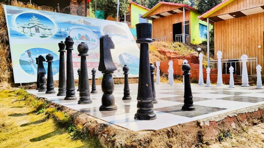
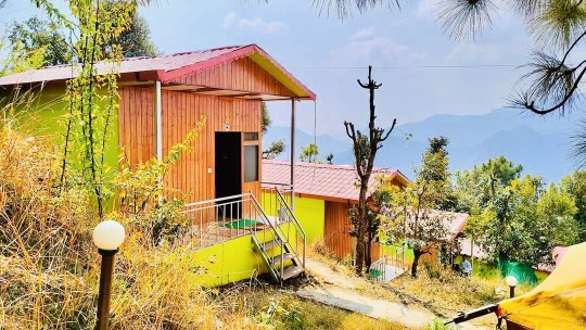

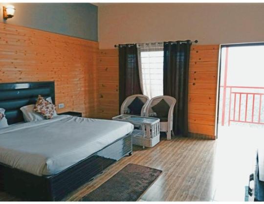
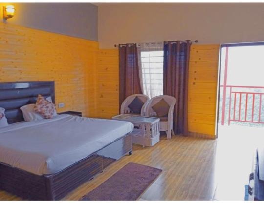


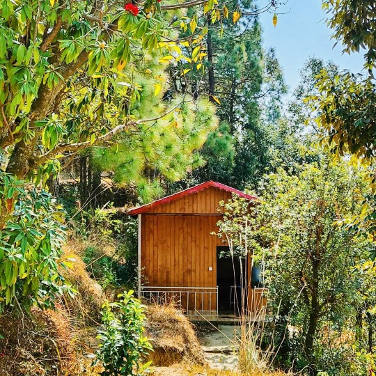
Best Resort Kanatal uttarakhand near dhanaulti
CALL US FOR BOOKING 9891532947
#KANATALCROWN #RESORTINKANATAL #DHANAULTI #UTTARAKHAND #TRIPTOKANATAL
ABOUT KANATAL
Hotel Kanatal Crown, a nature resort that is a precious jewel in the crown of Uttarakhand gives you a remarkable, alluring and bracing holiday experience. Set amidst majestic forests of pine, deodar trees, magnificent rhododendrons, fruit-bearing apple trees, terrace farms intricately carved along hillsides, Water Fall chirping birds all around and the fresh, invigorating mountain air, the impeccable lodging, travel, Wellness, adventure, conference, dining, and entertainment facilities at Hotel Kanatal Crown blend beautifully with nature's bounty.
Hotel Kanatal Crown is framed in a five acre plot with a view of snow-clad Himalayan peaks. Hotel Chakrata Homes offers 10 rooms and a suite with the excellent facilities which have been designed with careful thought to the most minute details and painstaking efforts, all aimed at enhancing the comfort and well being of our esteemed guests.
Hotel Kanatal Crown is one of Delhi’s nearest snow destination, occupying prime location on the Mussoorie Chamba highway, the high point of the year at Dhanaulti occurs between December and February, when over 50 inches of powder snow carpets its areas, creating a spectacular Cottonwood Canyon and transforms the landscape into a ravishing white wonderland. It’s a paradise where you can put your feet up, pamper your frayed nerves and take in deep breaths of the Frangipani-scented breeze that wafts across the resort. Best Resort In Kanatal, Hotels in Kanatal Crown
#uttarakhand#india#pahadi#uttarakhandheaven#travel#dehradun#himalayas#nature#uttarakhandtourism#mountains#incredibleindia#photography#rishikesh#travelphotography#himachal#uttrakhand#uttarakhanddiaries#kedarnath#uttarakhandtraveller#devbhoomi#instagram#nainital#love#garhwal#almora#uttarakhandi#diaries#travelgram#delhi#pithoragarh
4 notes
·
View notes
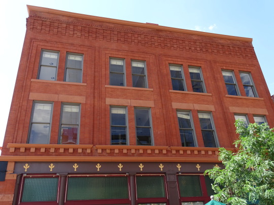
Photo
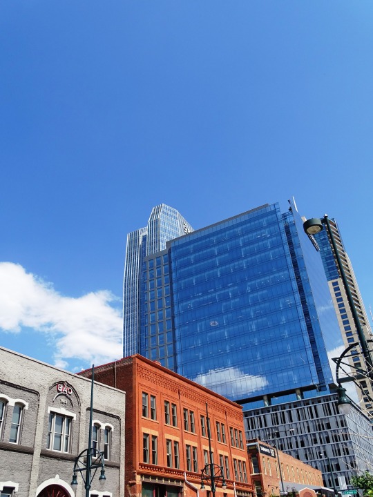

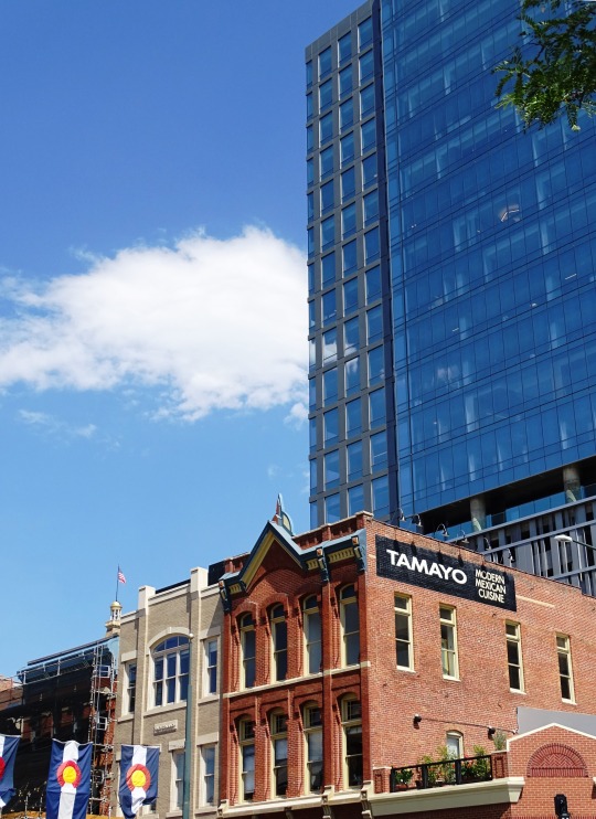

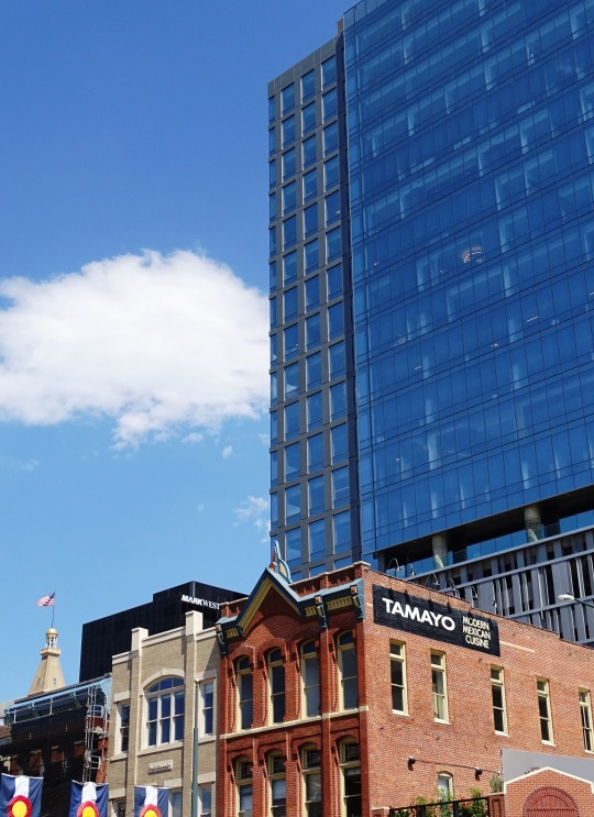


Downtown Denver (No. 7)
On November 22, 1858, General William Larimer and Captain Jonathan Cox, Esquire, both land speculators from eastern Kansas Territory, placed cottonwood logs to stake a claim on the bluff overlooking the confluence of the South Platte River and Cherry Creek, across the creek from the existing mining settlement of Auraria, and on the site of the existing townsite of St. Charles. Larimer named the townsite Denver City to curry favor with Kansas Territorial Governor James W. Denver.[30] Larimer hoped the town's name would help it be selected as the county seat of Arapahoe County, but unbeknownst to him, Governor Denver had already resigned from office. The location was accessible to existing trails and was across the South Platte River from the site of seasonal encampments of the Cheyenne and Arapaho. The site of these first towns is now occupied by Confluence Park near downtown Denver. Edward W. Wynkoop came to Colorado in 1859 and became one of the founders of the city. Wynkoop Street in Denver is named after him.
Larimer, along with associates in the St. Charles City Land Company, sold parcels in the town to merchants and miners, with the intention of creating a major city that would cater to new immigrants. Denver City was a frontier town, with an economy based on servicing local miners with gambling, saloons, livestock and goods trading. In the early years, land parcels were often traded for grubstakes or gambled away by miners in Auraria. In May 1859, Denver City residents donated 53 lots to the Leavenworth & Pike's Peak Express in order to secure the region's first overland wagon route. Offering daily service for "passengers, mail, freight, and gold", the Express reached Denver on a trail that trimmed westward travel time from twelve days to six. In 1863, Western Union furthered Denver's dominance of the region by choosing the city for its regional terminus.
Source: Wikipedia
#old city hall bell#Miller Building#Cherry Creek#Băo Brewhouse#Denver#1401 Lawrence#1144 Fifteenth#skyscraper#nature#Larimer Square#USA#reflection#LoDo#downtown#original photography#summer 2022#travel#vacation#architecture#cityscape#tourist attraction#landmark#Mile High City#Mountain West Region#blue sky#clouds
6 notes
·
View notes
Photo

After visiting with my Grandma I left to take my meandering way to TX. Visited a few places, but didn’t draw till I got to Salk Lake City, UT. A place called Big Cottonwood. The various greens was weirdly striking here. Strange to see trees at the top of mountains rather then the foot of them.
Image ID: A watercolor of a mountainous landscape. A yellow grass at the foot, saturated green trees and blue bushes on brown ground as the land rises, and a green-blue mountain in the distance - the trees getting denser higher up the peak.
5 notes
·
View notes
Text

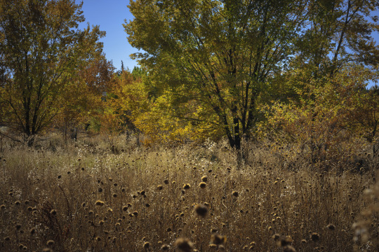
Cottonwoods at Peak Fall Colors...
not far from Willow Lake just North of the road.
15 notes
·
View notes
Text

Part 1 is out today!!! - Dark Peaks: Tales from the Mountain Shadows 👻 🎃 A collection of horror short stories that all take place in the Sacramento Mountains of southern New Mexico! Read it now at
Prologue: The Legend of Granny Agatha
In the small mountain towns of High Rolls and Cloudcroft, New Mexico, legends and folklore are as much a part of the community as the towering pines and the crisp mountain air. Tales of haunted cabins, mysterious creatures, and unexplained phenomena are passed down from generation to generation, told around campfires and whispered in hushed tones. But of all the stories that circulate in this secluded region, none is more enduring—or more unsettling—than the legend of Granny Agatha.
Granny Agatha is a name that has been whispered by the locals for as long as anyone can remember. No one knows her real age, but she's been around for decades, maybe even longer. She lives in a secluded house, hidden behind a thick grove of cottonwoods and elms, with a mountain ridge rising up behind the property, covered in pinion and ponderosa pines, scattered juniper, and scrub oak. The only sign of her existence to the outside world is her small egg stand at the end of a half-mile-long dirt driveway, right off Highway 82.
The stand is a simple affair—a wooden table covered with a faded cloth, baskets of eggs, and an assortment of seasonal fruits and vegetables. But it's not the humble appearance of the stand that captures people's attention; it's the eggs. Dark brown with a deep red hue, these eggs are unlike any you've ever seen. The yolks are a rich, jewel-like red, and the taste is unparalleled. Some even claim that the eggs have healing properties, attributing miraculous recoveries and unexplained cures to them.
But Granny Agatha is more than just an old woman selling eggs. She's also known as a healer, a wise woman who understands the secrets of herbs and roots, who can cure ailments that baffle modern medicine. She never advertises these skills, but stories circulate—stories of care packages left on doorsteps, of miraculous recoveries and lives saved.
Yet, for all the positive tales, there's a darker undercurrent to the legend of Granny Agatha. Pets have gone missing in the vicinity of her property, and some claim to have heard unsettling sounds—cries and whimpers, the clucking of unusually aggressive chickens—emanating from the depths of her land. Parents caution their children to stay away from the end of that long dirt driveway, especially as dusk falls. And every so often, a traveler passing through the area goes missing, their last known location somewhere along Highway 82.
1 note
·
View note
Text
What is Special About Great Sand Dunes National Park?
Great Sand Dunes National Park, nestled in the Sangre de Cristo Mountains of Colorado, is a unique American treasure. This park is a captivating blend of diverse habitats, natural wonders, and a myriad of outdoor activities. It showcases an incredible desert landscape amidst the Rockies, making it a must-visit for every nature lover.
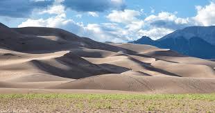
Discover the Desert in the Rockies
Picture a place where an expanse of desert sand dunes stretching over 30 square miles stands in stark contrast against the vibrant greens and rugged peaks of the Rocky Mountains. This is the charm of the Great Sand Dunes National Park. Housing the tallest sand dunes in North America, some exceeding 750 feet in height, the park presents a dramatic landscape alongside clear alpine lakes, lush forests, and craggy mountain peaks.
A Sanctuary of Biodiversity
Great Sand Dunes National Park is a hotbed of biodiversity, nurturing a vast range of life forms. Cottonwood trees and Indian ricegrass thrive on the sand sheets while alpine tundra serves as home to bighorn sheep and elk. For bird watchers, the park is a paradise with over 200 species of birds recorded in its domains.
Adventure Awaits You
Great Sand Dunes National Park is more than a sight-seeing destination—it's an adventurer's playground. From sandboarding and sledding on the dunes to camping under the stars, the park offers countless ways to engage with its beautiful surroundings. Explore the Medano Creek, or visit at night to enjoy the park's internationally recognized dark skies, ideal for stargazing.
Emphasis on Conservation
The Great Sand Dunes National Park plays a key role in conservation. Its management is dedicated to preserving the natural resources of the park while offering enriching experiences to visitors, including maintaining trails, conducting wildlife research, and implementing resource management plans.
In the spirit of embracing new landscapes, consider the decision to make a major life change such as relocation. Whether you're planning to venture to a new city or closer to nature, the thought of Sell Your House in Colorado can be an exciting starting point. Trusted resources and experts can make this transition smooth and hassle-free.
Conclusion
The Great Sand Dunes National Park is more than just a park—it's a testament to the captivating variety and natural beauty that America has to offer. Whether you're an adventurer, a wildlife enthusiast, or simply seeking solace in nature, the park has something special for everyone. Its unique allure serves as a reminder of the unexpected beauty life offers—similar to the invigorating feeling when you decide Sell Your House in Colorado and embark on new life adventures.
Purple Mountain HoldingsAddress: 3709 Parkmoor Village Dr Ste 105, Colorado Springs, CO 80917, United States
Phone: +17194762727
Website: https://www.sellmyhousetoday.com/
Google business profile :https://goo.gl/maps/cwGYwExMN7Gwrw7fA
1 note
·
View note
Text
World's Finest Heli-ski Operator 2022 « World Ski Awards
The helicopter may land but when this isn’t practical it's going to hover very near the snow so passengers can easily step out. Our return clientele come again to spend time with the PNH family just as much as to journey the products. AlpX Expeditions, Blackcomb Helicopters’ adventure tourism division, offers Heli skiing BC Heli Assisted Ski Touring in its exclusive tenure. If you’ve booked 4 runs, however feel like you might have extra within the engine, you can at all times add extra on the spot with the guide and pilot.
Access unimaginable surroundings and virgin powder by way of heli-skiing with Stellar Heli Skiing or Snowwater Heli Skiing. Experienced guides can take you on every thing from long powder descents to slalom runs through old-growth tree glades. From the easily-accessed peaks exterior the Whitewater ski area, to the distant alpine bowls of Kokanee Glacier Provincial Park, to the mystic Monashees and rugged Selkirk mountain ranges, adventure Heliskiing awaits. Many glorious unnamed runs await you in the distant and delightful Southern Carpathians of Romania. You can experience the feeling of being ‘way out there’ on this incredible surrounding with Heliski Romania and Martin Freinademetz, 2-time world snowboarding champion.
Get ready to improve and run through an unlimited amount of pristine powder. You will join a bunch of individuals seeking to depart the slopes and find their very own route. K2 Snowboarding has supported riders globally for over 25 years with genuine, progressive Heliski snowboards, boots, and bindings to create epic days within the snow. With this a lot wild in our yard, you may suppose we’d be robust to get to. Located between Revelstoke and Golden, Heather Mountain Lodge is among the world’s most accessible heli-skiing destinations.
It’s a part of our No Restrictions method to journey, and that includes COVID-19, too. “There is more heli-skiing alternative and accessibility but the terrain still requires a excessive level of skiing ability. Having an experienced information with a reputable operator who can assess your ability and match it to the terrain you ski is a must Heli skiing,” he mentioned. Heli-skiing is off-trail, downhill skiing or snowboarding that's carried out with out using a ski carry. It all began greater than half a century in the past when the first helicopters had been employed to visit isolated areas in Alaska and Europe.
Set out from a heli-ski base located among the many fjords of Baffin Island to succeed in untouched wildernesses that let you be the among the first to ski such slopes. Cookson hosts clients in a non-public assortment of Pacific Domes, which embody eating and club-house tents, while providing exploration of the slopes via snow-cat and helicopter. As properly as challenging yourself with some of the world’s longest couloirs and highest vertical cliff faces, you’re able to experience the tradition of the native Inuit folks. As above with the opposite gear, there are some advantages to utilizing rental gear from your heli op.
To warm up the legs, ski a number of days at Whitewater Ski Resort, it's noted as "Best Ski Town in North America". It pays to think exterior of the field when planning a heliski journey. The advice and suggestions listed about should allow you to to plan an reasonably priced heliski trip, but the one determination that may make the most difference to the ultimate Heli skiing Canada worth is the destination. Utah's premier heli-skiing operation flying out of Little Cottonwood Canyon. In a area that receives metres (40-60 feet) of snowfall each winter, Selkirk Tangiers will blow you away with unbelievable powder conditions. Although very distant, our friends get pleasure from easy accessibility with direct flights from Vancouver to Terrace, BC where they are met by our awaiting Heli for a 15 min transfer to their lodge.
0 notes
Last Seen Blogs

multifandomcentral
A Larry Larrie

urboredman
Eeasytogoup

okmack-22
kinley

azierella
Untitled

100quedaoficial
100 Queda Oficial