#alkaline lake
Text

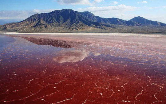
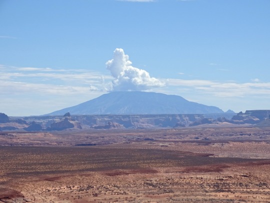
Lake Natron, Rift Valley, Tanzania
Photo by Juan Carlos Munoz
#lake natron#rift valley#tanzania#pink#pink landscape#lake#pink lake#alkaline lake#natron#landscape#landscape photography
10 notes
·
View notes
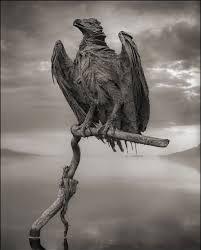
Text
Lake Natron, Tanzania, Africa
#lake Natron#tanzania#africa#scariest lake#mummified animals#stone animals#lake bahi#alkaline lake#alkaline water#reanimated alive again in death#terminal lakes#lesser flamingo#phantasmagorical#naturaltourism#geotourism#serene lake#east africa#red lake#sodium carbonate#minerals#petrified animals#dark tourism
3 notes
·
View notes
Text
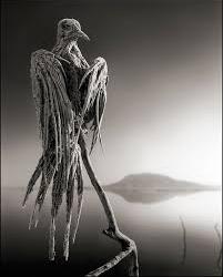


the mummified birds of lake natron, tanzania.
sources: [x] [x] [x] [x]
#calcification#alkaline lakes#lake natron#tanzania#saltlakes#nature#nature boy#animals#birds#bird photography#nature photopragpy#others creations
10 notes
·
View notes
Text

Step one: slit my throat
Step two: play in my blood
Step three: cover me in dirty sheets
And run laughing out of the house
Step four: stop at Lake Michigan
And rinse your crimson hands
You took me hostage you made your demands
I couldn't meet them so you cut off my fingers
One by one
One by one
Alkaline Trio
0 notes
Note
if possible i would love to hear various lake facts from swanatello

Swanatello is DELIGHTED to inform you that his lake has a varying pH level from 6.5 to 7.9 depending on the depth at which the sample was taken, and he has multiple graphs charting the water depth which he of course measures daily from a dozen different points. He has also measured the algae content, oxygen levels, total alkalinity, and phosphorous, as well as taking ammonia and nitrogen levels. He's in the process of identifying all the different minerals, chemicals, and algae growths that can be found in his lake-- speaking of, he's documented all the different variations of flora and fauna here and is working on data collection regarding behavior and growth of the different species if you wanna see the graphs for THAT-- His favorite is the big snapping turtle that lives at the bottom of the lake. They are just so FASCINATING for some reason...
Also, the bottom of the lake glows in odd patterns at night, which is weird? He's working on figuring that one out 'cause he's not really sure why that happens. The magick here is a little bonkers and he's still trying to figure out... how it works? And why?...
#swanatello LOVES to tell ppl all abt his lake#swanatello#risesona#donniesona#rottmnt#rottmnt au#rottmnt donnie#rottmnt donatello#fidgetwing#hehehehehehehe im so tickled that ppl like swanatello
869 notes
·
View notes
Text
Water 101 💦
The quality of drinking water can vary based on several factors, it's source, treatment, and the presence of contaminants.
Best Waters to Drink:
Spring Water: Sourced from a natural spring and is typically free from harmful additives and contaminants. It also contains beneficial minerals.
Purified Water: This is water that has been filtered to remove any contaminants. Methods like reverse osmosis, distillation, and carbon filtering can be used.
Filtered Tap Water: Using a good quality water filter can remove many of the contaminants found in regular tap water.
Bottled Water: While many people prefer bottled water for its taste and convenience, it's essential to choose brands known for their quality and sustainable sourcing.
Mineral Water: This is water that contains at least 250 parts per million total dissolved solids (TDS), which are minerals and trace elements. It can be beneficial for health due to the minerals it contains.
Worst Waters to Drink:
Unfiltered Tap Water: In some areas, tap water can contain contaminants like lead, chlorine, fluoride, and other harmful substances.
Distilled Water: While it's free from contaminants, distilled water lacks essential minerals. Drinking it exclusively can lead to mineral deficiencies.
Standing Water: Water from ponds, lakes, or puddles can be contaminated with bacteria, parasites, and viruses.
Water from Plastic Bottles Left in the Sun: The heat can cause chemicals from the plastic to leach into the water.
Untrusted Bottled Water: Some brands may not adhere to stringent purification standards, leading to potential contamination.
Quite a few brands actually combine their water bottles with non pure/non filtered water. However, there are several brands that are recognized for their commitment to providing pure water.
Fiji Water: Sourced from an underground aquifer in the remote Yaqara Valley of Viti Levu in Fiji, this water is naturally filtered and contains minerals like silica, magnesium, and calcium.
Acqua Panna: Sourced from a spring in Tuscany, Italy. The water takes a 14-year journey through the underground rock formations to reach the surface, which naturally filters and purifies it. It has a balanced mineral composition and a naturally alkaline pH.
Evian: Originating from the French Alps, Evian water is naturally filtered through rock and sand before being bottled. It's known for its balanced mineral content.
SmartWater: This brand uses a process called vapor distillation to purify its water. After distillation, it adds back a blend of electrolytes for taste.
Voss: Sourced from an underground aquifer in southern Norway, Voss water is protected from pollutants and is naturally low in minerals.
Penta: This brand claims to use a 13-step purification process, resulting in ultra-purified water.
Icelandic Glacial: Originating from the Ölfus Spring in Iceland, this water is naturally filtered through layers of volcanic rock, resulting in a low mineral content.
Essentia: This brand uses a proprietary process to purify its water, and then infuses it with electrolytes for taste. It's known for its high pH, which is alkaline.
Pure Life (Nestlé): Sourced from carefully selected springs, this water undergoes a multi-step purification process and is enhanced with minerals for taste.
Make sure that any water you drink, whether from a bottle or tap, is stored and handled properly to prevent contamination.
#health and wellness#healthy living#health#drink water#water#healthy lifestyle#health tips#health and nutrition#wellness#health is wealth
325 notes
·
View notes
Text
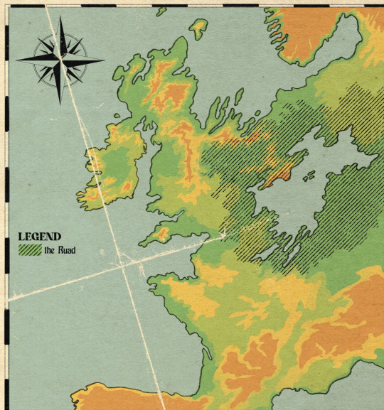


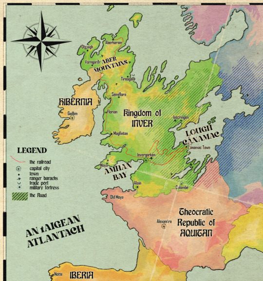
Inver - relief map relative to the continent with otherworld territory marked, broad habitat map, detailed local landmarks map, and political map of the northeast atlantic peninsula as of 1862
i was just having map fun for two days lol. i make habitat maps a lot already but the difference with this one is that i can't just download a handy shapefile and do some GIS magic. this was hand drawn (but obviously. somewhat traced over the actual irl map)
for the outline of the north sea coast i used bathymetry data to figure out where the true coastline would occur. the north sea recedes but the atlantic doesn't (to the same extent). because this landmass was formed through some ancient Event, i felt pretty okay about changing the bedrock because like, whatever, we can't be fully realist all the time. so the northern half of inver is mainly limestone, the southern half is silicaceous - so we got the bog/marl divide there, though lough cánamac (in volume slightly larger than any of the north american great lakes) appears to be the remnant of the north sea, it is freshwater with a relatively low pH. the water of the lough is black to dark brown due to the run-off from the southern bogs and swamps.
in the north, the mountain ranges are calcareous. calcareous grassland, scrubland, heaths and fens dominate with a largely alkaline profile. limestone marl lakes which regularly flood due to groundwater input make the region pretty unsuitable for crops other than rice.
the ruad is the name for a stretch of otherworld territory which contains the lough, though generally used to refer to the forested area. it is completely uninhabitable throughout the majority of its range due to the non-euclidian structure of the land making it impossible to navigate consistently, and the strange and frequently hostile creatures living there. the ruad is faery territory and belongs to an entity known as the Red King, who uses the symbol of a stag. so although inver may look like a large country compared to its neighbours, it has a relatively small population concentrated on the west coast.
however, sailing across the lough is the quickest way to trade with countries in the east, far quicker than trekking through the forest and over land. the trade route through the ruad from invergorken to the cánamac town is one of the most valuable in the continent. it consists of an old road with regularly-spaced ranger safehouses and patrols, and a newer pair of railway lines which can cut through the supernatural aura of the ruad due to their iron rails. the first and older line is no longer in regular use. it was constructed before the development of wrought iron and before the build crews learned how to blast through rock, so it takes a very slow and winding route and required a lot of maintenance. safehouses were constructed to board the workers while the tracks were laid. but without this original track, the construction of the second, far more advanced wrought iron track would have been impossible. workers for the second track were able to commute and sleep on the first track's train, keeping them from harm. the second track can fit two trains side by side and is in constant use ferrying cargo and passengers between the two towns
the country of inver, once The Event wiped out all of its original inhabitants a couple thousand years ago, was settled by hibernians and vikings from the north moving south, and aquitanians from the south moving north (thus the place names). the ruad mostly blocked incursions from the east. there was a long history of dispute over who truly owned the land, and that remained sort of up in the air for most of its history until the 1400s when armorican warlords (like Olivier) decided to make it theirs for realsies and waged war against their old hibernian trade partners (like Finbarr) for control of the land. the hibernians lost because finbarr fucked it up at the last second, and this cemented a ruling class of werewolves in inver until the 1860s
inver consists of three large duchies which cover 70% of the population. Moya in the west is the heart of lycanthrope rule, everybody worships a faery known as the immortal hound and the ruad is far enough away that it is not a fact of life as it is for everyone else. Inver duchy covers the capital city and the south-western farmland, the main sites of production in the country. And Cánamac duchy covers the trade port in the lough and surrounding territories, where forest clearing has led to new farmland and a thriving population. There was a fourth duchy in the north, Aber, but it was historically somewhat isolated and cut off from the south of the country and had developed its own customs and traditions, and its own form of the country's currency. In the 1840s, the duchy of Aber was dissolved and reconstituted into the king's lands, and southern customs were enforced in the north to prevent any more divergence. the palaces of the ruling families in each territory are shown in the local map alongside the family names.
Due to The Event causing massive damage in this region of Europe, forbidding the development of britain and france etc as colonial empires, the last great Empire of this continent was the roman empire, and even that didn't manage to overcome the Ruad. technology is rudimentary in Inver and the people living there are largely considered to be weird backwards superstitious barbarians. aquitan has been threatening annexation for decades, led mainly by the church of suzette, which forbids interaction with otherworld entities. the church holds in disregard the nobility of inver and their cultish ways, and as a result has been banned from attempting to convert inver citizens. but the church is still allowed to make minor inroads into inver for one very important reason: penicillin and antibiotics are the sole creation of the church, and the secret of how they are made is unknown outside suzette. so for the sake of good, advanced healthcare, the church is allowed to set up clinics and hospitals, on the condition that nobody is converted, and members of the church are strictly banned from engaging in any business but importing and selling antibiotics
#ignore me using the wrong orthography in several places#setting: inver#northeast atlantic peninsula bro what happened to u... oh no.. he died...#none of that is spoilers under the cut it's just like. basic history everyone knows
524 notes
·
View notes
Text

Quetzalcoatlus lawsoni by corvarts. Unlike it's larger relative Q. northropi, which occurs in plains deposits, Q. lawsoni occurs exclusively in alkaline salt lake deposits. This seems to hint at a flamingo-like lifestyle, perhaps having displaced ctenochasmatoids in this regard.
182 notes
·
View notes
Note
Elder Bones, can we get more info on ShadowClan's territory? They live at a bog, right?
I won't put out too much yet, because I want to make another research guide on wetlands in England the way that my lowland heath document covered what moorland is. That research opened my eyes to how important peat, fire, and management should be to WindClan's culture, and so I'm expecting something similar to happen when I dive into what their bog is.
But I DO know that the bog of the Forest and the bog of the Lake are going to be quite different. That is because the Lake is in active development during the Settlement Era (Po3), where the old Forest bog was downright medieval-ancient.
The Lake bog also has a SPECIFIC NAMED model, unlike the others which take a little from a lot of areas. It's the Black Moss in Delamere Forest-- a developing quaking bog which is an EARTH-SHATTERING success for the Wetland Vision project in the UK. I'm in love with it. I want to learn everything about it and explain why it's so awe-inspiring
(The area is also fucking gorgeous btw, I want to show everyone pictures of how breathtaking it is-- the moss enfolds the ground like a velvet blanket and the water seeps up to meet your step. The trees sprawl above you and cast dappled sunlight on the greenery, as if the sun is painting the definition of beauty before your very eyes. Also theres toads)
Anyway though, some various things about bogs;
Bogs are acidic, a fen is alkaline. I know very little about fens, besides that there's a few of them in the south
Like moor, bogs are so important for carbon capture that the destruction of any wetland makes me feel physically ill
Dead matter is quickly covered by fresh, living things, so the bottom layer is basically in permanent arrested decay
because of that, gas bubbles to the surface on occasion. That's why they're smelly sometimes! It means there's MUCH MORE down there that the bog is saving you from!! You're WELCOME!!!
It's a pretty bad area to be in over winter; everything freezes, falling into the water can become deadly, and a lot of the prey hibernates.
In other seasons, it's bountiful. Insects, amphibians, frogs, birds, fish, and mammals live here, you can get some good eats in a bog. ShadowClan has the most varied diet of the forest four.
A "swamp" is actually a term that refers to forested wetlands. "Marsh" is not covered by trees.
Medicinal leeches are supposed to live in wetlands but with the decline of natural livestock management their populations have crashed :(
69 notes
·
View notes
Photo

Smaugust day 17 - Volcano
outliers of the natural world, Myngo-Ahzdars are widely thought to be Dragons. their environments of choice are often considered too hostile for the average person to venture to just to see some weird beasts, that and the animal’s general unpalatability leading to a lack of knowledge. it is thought they sift volcanic material from the toxic alkaline lakes they populate, feeding their young and colouring their feathers with magma. it is even believed they can spit molten rock in place of dragonfire. indeed, these are just flightless pterosaurs occupying a flamingo’s niche, filtering tiny prey from the brine. dragonkin are theropod dinosaurs, meaning the Myngo-Ahzdar doesn’t even count as a pseudo or false dragon like a drake, though the popular opinion of lava-eating dragons still prevails in most areas.
(these are a fictional design for a fantasy world-building project, not representing any real genera aside from being an Ahzdarchid!)
#fraizer draws#smaugust#smaugust 2022#pterosaur#azhdarchid#myngo-ahzdar#nevverse#fantasy#Creature Design#paleoart#speculative evolution#speculative biology#pterosaurs#dragons
713 notes
·
View notes
Photo


Ballet + Flamingo Fakemon 🦩🩰
Mainly inspired by the Lesser Flamingo, which nests in volcanic alkaline lakes!
#Mattibeearts#fakemon#flamingo#oripoke#creature design#ballet theming was p much out of convenience#i wanted them to be graceful and a bit uppity and i also wanted them to have armored legs#i couldve probly spend a bit more time making them look like ballet shoes but eh close enough
575 notes
·
View notes
Text
Submitted via Google Form:
Hi, I'd like to build a planet with land across the entire planet that is mostly an alpine. I'm thinking that the majority of the land will be tall mountains with almost all shorelines being tall cliffs so even areas close to the ocean can quickly become tall mointains. Places near the equator will have the highest mountains to offset being closer to the sun. How about resources though? What would be abundant, what puld lack? How about other geographical features and conditions that allow a planet to look like this?
Tex: What happens when the tectonic plates meet? Mountains are created via only one type of plate movement (Wikipedia), but due to physics the opposite side of that plate would create the opposite result (Wikipedia). In order to dissipate the forces caused by a plate causing convergent and divergent boundaries, the horizontal movements of a transformation fault would develop (Wikipedia).
Resources can be boiled down to approximately two things: what grows in water, and what grows in soil. For the former, oceans, seas, lakes, and related areas would need to exist and be large enough to develop life of higher trophic levels. For the latter, it would need enough erosion of rocks to create soil, and be propagated by bacteria to facilitate a healthy environment to propagate photosynthetic life and the upper trophic levels that rely on it. (Birds exist, but also birds must roost, so for all intents and purposes they rely on what grows in soil.)
Anything that has above-water places high enough to create what we would subjectively perceive as mountains would have to be an extremely geologically-active planet, where the plates are constantly moving. This would mean things like lots of volcanoes, and likely an atmosphere saturated in gases like sulfur. Extremophiles can grow in these conditions, but because of energy conservation in a geologically-hostile environment, they’re not likely to grow very big.
If you wish for something different, it might be a “dead” planet, in which there’s little geological activity and the state of things like mountain ranges and placement of oceans are effectively locked into place. This would mean an inert core, and possibly a dying planet or else one in a solar system where it’s faced with a dying sun or outside the goldilocks zone of a reasonably active sun.
Addy: So, resources. That's my jam. If you've got a heavily alpine area, you're generally on mountains or mountain slopes, which generally means you're going to be on a whole bunch of rock. That rock could be sedimentary or metamorphic (igneous is also possible, basalt mountains do exist), but it's still rock. Things that rely on heavy amounts of soil - sand, clay, loam, otherwise - will struggle to form into industries.
You might have 3-4 feet of soil ("soil" includes sections that are mostly gravel – if you're looking for dirt, probably only a foot or two). Looking at a couple examples, I'd say you're probably going to get sandy loam, loamy sand, and gravelly loam. Great drainage, not good for food crops. Since you're alpine, that's going to mean you're above the tree line, so timber is going to be scarce as well. Neutral pH to somewhat alkaline, if that matters to ya. Also, above the tree line, the winds get to be very, very harsh - harsh enough that most plants can't survive up there, so crops are doubly not an option.
If you've got a freeze-thaw cycle, then the ground is going to sprout rocks every year in the spring (literally, the freeze-thaw cycle pushes rocks up towards the surface from under the ground, so you get new rocks in your fields every spring as it starts to thaw), so stone for walls and homes will be plentiful. Insulation will likely come from packed earth (e.g. Icelandic turf homes) or animal hides (e.g. yurts). Without good soil for growing, you're going to likely see a lot of animal husbandry - yaks, goats, oxen, and sheep. Maybe small horses, but no large horses; large, Western horse breeds don't do well if they're only grazing - they generally have feed grown for them. Draft horses are large enough that they have to have food grown for them. But ponies are an option.
Your sand will likely be difficult to get separated from the loam/gravel, so glass will be a tricky industry. Clay will be hard to find, so pottery is limited. Also limiting those industries is a lack of easily available fuel - without timber or peat, you've got limited options on what you have available to burn.
If, by alpine, you're also talking about mountain slopes (and maybe valleys?), then you'll have lots of timber. Lots and lots and lots of timber, so long as you don't clear-cut. Berries will be plentiful in the spring and fall, you'll generally have a decent supply of water, you can grow crops if you're careful about your growing seasons (and the ground acts as a refrigerator, so root cellars and similar structures act as a way to preserve food through the winter months), and you've got wild game to supplement.
Animal husbandry is still an option, though you'll almost certainly need to grow feed to keep them fed over the winter. Goats would do better than sheep, I think, but birds (chickens, ducks, partridge, geese) would probably be the easiest animal to raise. With birds, you'll also get down, which will help for quilts and bedding to keep yourself warm at night. Sheep/goats will get you wool, which will be good for clothing to keep warm. If you've got different animals, whatever birds/mammals they've got nearby that can fill the niche.
For fuel, you've got wood and charcoal. Charcoal is made from wood, and it burns hotter and cleaner than wood. Good for large kitchens… or for kilns. Or for metalworking. Or for writing/art. Wood is easier to get, and more suitable to everyday use.
Valleys tend to accumulate clay, gravel, or sand, depending on how fast the water flows. Steep slopes mean fast water, so you'll mostly get gravel. Mild slopes mean slow water, so you'll get a lot of clay (such as many river deltas, where they meet the ocean). Moderate slopes mean medium-speed water, so you'll get sand (or sand with gravel). River sand may not get you high-quality glass, but you can still make basic glass out of it. When the rivers freeze in the winter, you'll have lots of ice. That can be stored underground in ice houses, so that you have ice year-round.
For lime/quicklime, you'll need shells (so beach) or limestone (so depends on mountains type). Lime is used for a variety of things - making mortar for bricks, removing impurities when making iron, making concrete, etc - but you need limestone (or shells, like oyster shells) and fuel to make it. So that really depends on the type of stone the mountains are made of.
Salt may or may not be plentiful, depending on what the mountains are made of. You've got very little ocean access (since cliffs), so drying out seawater for salt isn't going to be effective for large-scale production.
Either way (with or without trees), trade will be difficult. Overland trade will have to deal with snow, ice, and uneven terrain (plus possible food issues for pack animals). Sea-based trade would have to deal with getting goods up or down those massive cliffs without damaging or dropping them.. and also getting people down there, too. Huge altitude changes.
Wootzel: If your main concern is having your planet chilly, you could look at Earth during the last ice age as inspiration. This would probably result in having a planet with a LOT of nigh-unlivable area near the poles, but it could be a way to make most of your land quite cold without having to rely as heavily on high altitudes, if that’s something you want to look into.
17 notes
·
View notes
Note
tumblr user tangerisms i would LOVE to see your other nhl playlists please share with the class im begging
oh i have SO many thank you for asking
(i made the panthers and wild top 100 ones rn, ill add the matching rosters at the end. also expect repeat songs bc its based on the top songs i had last year)
the other two ive had for a little while now are both pens based but i should really get onto making more
and ofc, silly little sergei fedorov
(i also have playlists on my profile with silly nhl photos on them)
florida panthers
5 - aaron ekblad - something in the orange - zach bryan
7 - dmitry kulikov - not allowed - tv girl
9 - sam bennett - roslyn - bon iver
12 - jonah gadjovich - work song - hozier
13 - sam reinhart - skinny love - bon iver
15 - anton lundell - howl - florence and the machine
16 - aleksander barkov - like real people do - hozier
17 - evan rodrigues - exeunt - the oh hellos
18 - steven lorentz - everywhere, everything - noah kahan
19 - matthew tkachuk - lake missoula - richy mitch and the coal miners
21 - nick cousins - francis forver - mitski
23 - carter verhaeghe - sanctuary - joji
24 - justin sourdif - the moon will sing - the crane wives
27 - eetu luostarinen - sage - richy mitch and the coal miners
28 - josh mahura - tongues and teeth - the crane wives
41 - anthony stolarz - alkaline - sleep token
42 - gutav forsling - homesick - noah kahan
62 - brandon montour - willow tree march - the paper kites
67 - will lockwood - in the woods somewhere - hozier
72 - sergei bobrovsky - demons - joji
77 - niko mikkola - pumpkin man - mage tears
82 - kevin stenlund - it will come back - hozier
91 - oliver ekman-larsson - through me (the flood) - hozier
94 - ryan lomberg - the calling - the amazing devil
wild
4 - jon merril - eat your young - hozier
5 - jacob middleton - something in the orange - zach bryan
6 - dakota mermis - stick season - noah kahan
7 - brock faber - not allowed - tv girl
10 - vinni lettieri - northern attitude - noah kahan
12 - matthew boldy - work song - hozier
14 - joel eriksson ek - all my love - noah kahan
17 - marcus foligno - exeunt - the oh hellos
20 - patrick maroon - wasteland, baby! - hozier
21 - brandon duhaime - francis forever - mitski
23 - marco rossi - sanctuary - joji
24 - zach bogosian - the moon will sing - the crane wives
25 - jonas brodin - i was all over her - salvia palth
26 - connor dewar - dial drunk - noah kahan
29 - marc andre fleury - sunlight - hozier
32 - filip gustavsson - never love an anchor - the crane wives
33 - alex goligoski - alien blues - vundabar
36 - mats zuccarello - in a week - hozier
38 - ryan hartman - orange juice - noah kahan
46 - jared spurgeon - chokehold - sleep token
49 - daemon hunt - the moon doesnt mind - lord huron
89 - freddy gaudreau - a burning hill - mitski
90 - marcus johansson - little lion man - mumford and sons
97 - kirill kaprizov - memento mori - crywank
#i love when people are just as insane about music as i am#i also have a silly pinboards on pinterest for ideas ive had surrounding players / teams if anyone wants those too :3#florida panthers#minnesota wild#pittsburgh penguins#sergei fedorov#panthers#wild#pens#i aint taggin all those people#playlist
7 notes
·
View notes
Note
So now I’m curious:
What are the Three Big Lakes of Africa?
Signed,
Geographically-challenged American 😆
Tee hee! Thanks for being curious!
So the Maziwa Makuu, known as the African Great Lakes, all lie within the tropical zone along the Great Rift Valley in East Africa. Collectively they contain a quarter of the world's fresh unfrozen surface water and about a tenth of the world's species of fish.
The largest is Nyaza (Lake Victoria), second largest in the world by area after Superior. It's the primary source of the White Nile and is surrounded by Kenya, Tanzania, and Uganda.
Next is Lake Tanganyika, the longest lake in the world, the second largest by volume and, at a depth three and a half times that of Superior, it's also the second deepest. Its youngest basin has been around for over 3 million years and its oldest for around 10. (Lake Baikal in Siberia is the deepest, biggest by volume, and oldest.) Tanzania, DRC, Zambia, and Burundi share it, although it probably laughs at the notion of nations.
Lake Malawi is the third by area, although second by depth (almost twice as deep as Superior) and is another ancient lake. It is alkaline and also meromictic, so the upper and lower waters don't mix. It contains the most species of fish of any of the world's lakes, and as the water is remarkably clear and averages 80°F at the surface, it's fantastic for snorkling and diving. Tanzania also borders this lake, along with Malawi and Mozambique.
:)

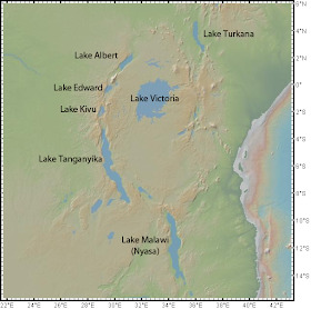
(Oh, and although not one of the Great Three Lakes, Turkana is in the Rift Valley System and I'd forgive you if you remember it as Lake Turukáno. In fact, I'll be impressed if its remembered at all!) 😉
28 notes
·
View notes
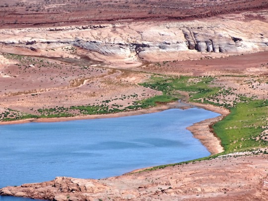
Text


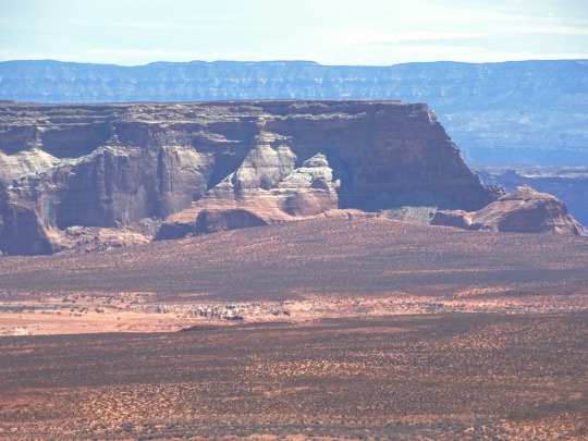

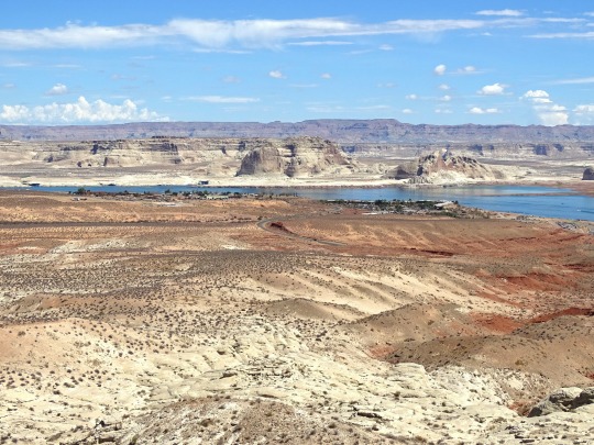

Wahweap Overlook, AZ (No. 3)
Kaiparowits Plateau
Opposite Navajo Mountain, the Kaiparowits Plateau reaches in from your left. Though the origin of its name is unknown, some sources have revealed two possible, yet unsubstantiated meanings: “Big Mountain’s Little Brother”, or “One Arm”. One thing is certain, archeological evidence reveals the fact that Ancestral Puebloans hunted and gathered here. The diversity of the Pinion-Juniper woodland provided nuts, berries and grains to gather, as well as rabbits and deer to hunt. What kind of tools do you think prehistoric humans created to help them survive in a harsh desert environment?
Wahweap Creek
Nested on the edge of the canyon, Wahweap Marina serves as a destination resort and launch point for modern day explorers seeking recreational adventure on present day Lake Powell. Wahweap Bay curves around from the left eventually joining the main channel of the Colorado River. Before the building of Glen Canyon Dam, Wahweap Creek meandered as an intermittent stream. Along this channel, seeps and springs occur, and the Paiute name of Wahweap, referring to the bitter taste of these alkaline seeps, is bestowed upon this canyon. Early river runners hiked up Wahweap Creek to seek out these cool grottoes. Other seep springs thrive within Glen Canyon providing vital habitats for many plant and animal species. Our continued stewardship will help protect these fragile and unique habitats.
Source
#Wahweap Overlook#Lake Powell Lookout Point#Glen Canyon National Recreation Area#Glen Canyon NRA#GCNRA#Coconino County#Southwestern USA#Colorado Plateau#desert#flora#nature#blue sky#clouds#grass#travel#original photography#vacation#tourist attraction#landmark#landscape#countryside#USA#Arizona#summer 2022#red rock#Page#Colorado River#detail#close up#Lake Powell
8 notes
·
View notes
Note
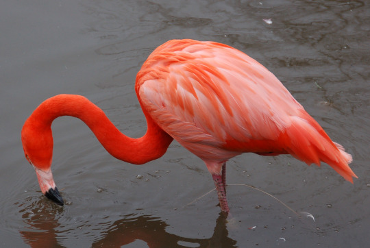
Can you tell me more about flamingoes if you want to?
I CAN YES!!!!! i am not sure what type of stuff you would want to know about flamingos so i will go for something simple :•]
there are actually only 6 species of flamingos today, of which there are the Greater flamingo, Caribbean / American flamingo, Andean flamingo, Chilean flamingo, James Flamingo, and Lesser flamingo! personally my favorite is the lesser flamingo but i will get into all of them
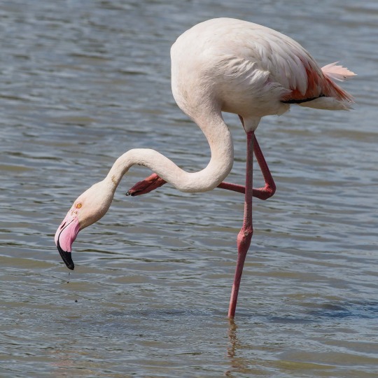


greater flamingo | chilean flamingo
caribbean / american flamingo | andean flamingo
james flamingo | lesser flamingo
the credit order aligns with which flamingo is which! from what i've seen, i think people primarily think of a pinker andean flamingo when they typically think of a flamingo, because of the iconic yellow legs and beak! even though james flamingos have yellow-er beaks hehe. i honestly don't think the colloquial flamingo is based off any one flamingo and more just a hybrid, but one can take guesses!
and hmmm. i'm not used to infodumping about flamingos i just post about them a lot so i am not really sure where to go from here. i just have a lot of disconnected flamingo facts floating in my head alskdfjaldkfj so!
my personal favorite is flamingos have a form of crop milk which is like. if you have the milk that mammals make, then you have crop milk, which is named adequately because afaik, it's usually white and produced in the crop of a bird, then fed to their young! but one step further is flamingos crop milk, which is blood red due to the stuff that makes flamingos pink, carotenoids! same thing functionally but it's blood red which is awesome and so cool.
and another thing is lesser flamingos can drink water that's near boiling and primarily reproduce in lakes so alkaline that they will burn your skin! my favorite extremophiles <333
this feels like not a lot of information but it might be a lot i am not sure but!! my thoughts are very disconnected unless i have a specific starting point so i hope this is adequate flamingo information for a start :D
oh and since i think you came here from me talking about flamingos loafing under your image id, here is the post where i posted the loafing flamingo!!
#flamingos <333#thank you for asking they are my favorite beasties ever and i am glad i have the opportunity to speak about em ehehe#bit.txt
11 notes
·
View notes
Last Seen Blogs

tommoisms
Never forget you're beautiful..

brigrff-blog
تركيب اثاث ايكيا

timeslugarts
Drawing thangs

traaanskimkitsuragi
no. 1 anders apologist

briarfangs
The Mounders #1 Fan