#skirrid hill
Text
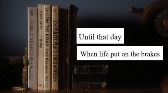
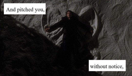

the perks of being a wallflower (2012) // excerpt from 'border country' by owen sheers (2005)
screencaps credit to @thelogicofthetrance, @artfilmaesthetics and @palegallerie
#the perks of being a wallflower#perks of being a wallflower#logan lerman#stephen chbosky#the perks of being a wallflower film#perks of being a wallflower movie#poetry#owen sheers#skirrid hill
50 notes
·
View notes
Text
Fractured Landscape - Neurological Event
Philosophical Topography and Anomalous Experience
The esoteric form of the essay, constructed to polarise the opaque element and release the latent forces in it, sparks moments of sudden reciprocal insight, in which the deeper the remoteness which a glance has to overcome, the stronger will be the spell that is apt to emanate from the gaze.
The essay has to cause the totality to be illuminated in a partial feature, whether the feature be chosen or merely happened upon. The catalyst for this essay, abandoned by the birds for which it was intended, is a derelict dovecote on Gop Hill, North Wales. As an earthly ruin, in the retrospective unfolding of strange encounters through the medium of the essay I found a celestial correlate in the Talmudic tradition that the Messiah will not come until the ‘heavenly birdhouse’ (Guf - note the accidental resemblance to Gop) is emptied of all its souls. See Geoff Dennis, January 14, 2007, ‘The Guf: Mystical Body, Well of Souls' http://ejmmm2007.blogspot.com/2007/01/guf-mystical-body-well-of-souls.html.
The speculative drift on this feature, with its intimations of a lost transcendence in the departure of the doves, prefigured the appearance of a migraine aura, the form of scintillating scotoma of its visual fortifications imitative of the stepped outline of the dovecote's gable, known as 'crow steps'.
Nearly two years on, a similar intensity of focus directed towards an archaeological feature, Arthur's Stone - seemingly aligned on a 'Holy Hill', known as The Skirrid - coincided with more drastic neurological symptoms. It was as if there was some correspondence between the fissure in the capstone of Arthur's Stone, inspiration for the Stone Table on which the Christ-like figure, Aslan, was sacrificed by the White Witch in C.S. Lewis’s The Lion, the Witch and the Wardrobe, and the small stroke undergone during this period of heightened attention. At the precise moment of Aslan's resurrection, the Stone Table fractures, fulfilling a prophecy that ‘the Table would crack and Death itself would start working backwards’.

A remarkable conjunction was noticed with the tradition that The Skirrid - the strange hill on which Arthur's Stone seems to be aligned - was struck by lightning or an earthquake at the moment of Christ's Crucifixion, causing a landslide. Interjecting Adorno’s words on the late style of Beethoven:
Objective is the fractured landscape, subjective the light in which – alone – it glows into life. He does not bring about their harmonious synthesis. As the power of dissociation, he tears them apart in time, in order, perhaps, to preserve them for the eternal. In the history of art late works are the catastrophes.

Read more: 'Between Fractured Landscape and Neurological Event: A Philosophical Configuration of Anomalous Experience'
#Aslan#Theodor W. Adorno#Walter Benjamin#Coincidence#Anomalous Phenomena#The Lion the Witch and the Wardrobe#Arthur's Stone#The Skirrid#Stroke#Migraine#Archaeology#Megaliths
1 note
·
View note
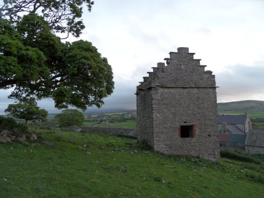
Photo


a walk around the Skirrid with Nuala, in which i had to sit on the ground and eat many crisps because i went so lightheaded marching up the hill.
1 note
·
View note
Text
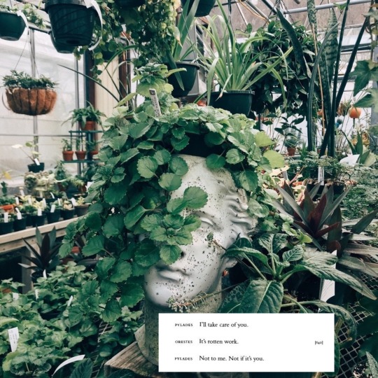


euripides
Walden ~ Henry D. Thoreau
„Intermission“, Skirrid Hill ~ Owen Sheers
#euripides#pylades#orestes#walden#henry d. thoreau#thoreau#intermission#skirrid hill#skirridhill#owen sheers#owensheers#apollo bust#apollo statue#apollo#jmw turner#jmwturner#dark academia#academia#nature#plants#greek#ancient greece#dark academia aesthetic#nature core#plant academia#literary quotes#literature#poetry
50 notes
·
View notes
Text
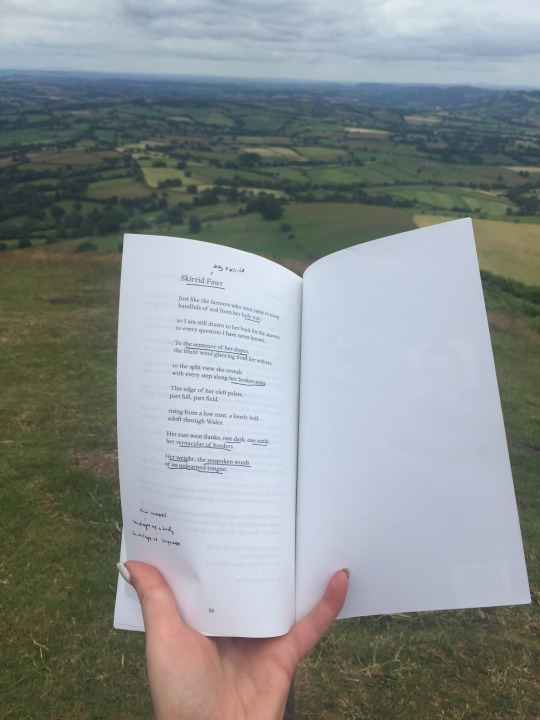
Probably the coolest thing I ever did to enrich my reading- taken from the top of skirrid hill, or in welsh, skirrid fawr
#english literature#studyblr#a levels#owen sheers#skirrid hill#we met him after this in a pub#and he signed my text#studyspo
6 notes
·
View notes
Text
Books I Read In 2018:
1. A View from the Bridge - Arthur Miller
2. Lord Of The Flies - William Golding
3. The Hiding Place - John Burley
4. A Streetcar Named Desire - Tennessee Williams
5. Field Work - Seamus Heaney
6. Skirrid Hill - Owen Sheers
7. The Perks Of Being A Wallflower - Stephen Chbosky

#a view from a bridge#reading#booklover#2018#lord of the flies#the hiding place#a streetcar named desire#field work#skirrid hill#the perks of being a wallflower
2 notes
·
View notes
Photo
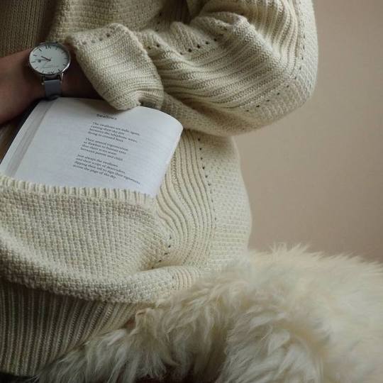
poetry in my pocket
#puppy in my pocket#look if you didn't read that like the jingle you're wrong#I don't care if that doesn't exist in your country#paperbackphoenix#photography#books#bookstagram#booklr#book#reading#read#reader#book photography#photo#poem#poems#poetry#autumn#owen sheers#skirrid hill
329 notes
·
View notes
Text
I’m such an idiot. So I lost my skirrid hill book and was really upset, especially as Owen Sheers signed it. Anyways I just found it, was so excited, opened it up and was slapped with my dead name
#I forgot he wrote a message and obvs address it to me but I wasn’t out so#anyways Sheers is an absolute gem he was so nice to talk to and his poems are really good I would recommend reading them
2 notes
·
View notes
Text
Top 5 Summer things to do in Abergavenny
1. Explore the castle and museum
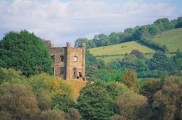
The ruins of the town’s Norman castle are set high above the river Usk with super views to the Blorenge mountain. On fine days you might see paragliders launching from the top of the Blorenge and landing in Castle Meadows alongside the river. In a Victorian hunting lodge built on the site of the original keep (which was destroyed during the Civil War in the mid-17th century), you’ll find the town’s museum. Throughout the summer holidays, there are free explorer trails and family activities here.
To delve further into Abergavenny’s history, follow the Trails and Tales for families route around the town. Start at any point on the walk (noting that the Tourist Information Centre has moved to the Tithe Barn near St. Mary’s Priory Church) and look out for the heritage plaques. Stop off at St Mary’s Priory Church to see a superb selection of medieval monuments including the 15th century Jesse Tree.
If you’ve time to venture outside Abergavenny, you can see magnificent birds of prey in action at Raglan Castle on 21 August and meet 15th century re-enactors at Tretower Court and Castle on 24-26 August.
2. Climb a mountain

Take your pick from the three mountains surrounding the town: Sugar Loaf, Blorenge and Skirrid Fawr. The highest, Sugar Loaf, standing at 1,955 feet (596 metres), has a distinctive cone-shaped peak and is a 9 mile (14.5 km) circular walk from the centre of town. Known as Pen-y-Fal in Welsh, it is cared for by the National Trust and has a car park at Llanwenarth on its south side which makes it an attractive choice if you fancy a shorter hike to the top.
From the summit on a clear day, you’ll have breathtaking 360° views which extend as far as the Brecon Beacons to the west, Hatterall Hill to the north-west and the Severn Estuary to the south.
3. Visit the market

Hardly a day goes by when there isn’t something for sale in the Victorian market hall – crafts, local food, antiques and so on. It’s also one of the main venues for the annual Food Festival held in September. You’ll need to use the rear door while renovation works are taking place on this historic building during 2019 but no visit to Abergavenny is complete without a browse around the market.
4. Enjoy a picnic

Linda Vista Gardens is a beautiful picnic spot, with green space, well-kept flower borders, specimen trees and meandering pathways. Originally a private garden, it has amazing views across Castle Meadows towards the Blorenge mountain. The grounds of Abergavenny Castle is another popular picnic place with plenty of benches. Families also enjoy picnicking in Bailey Park in the centre of town – complete with play-ground for children, vast green spaces and a path around its circumference which is great for running and gentle cycling.
But, before you head for your picnic spot, pick up a tasty selection of food from the independent cafés, delis, butchers and bakers in town. You’ll be spoilt for choice.
5. Wander along the riverbank

The river Usk which flows through Abergavenny is a Site of Special Scientific Interest and one of the UK’s best rivers for salmon fishing. But you don’t need to be a keen angler to appreciate this stretch of water – just head down to Castle Meadows, a glorious spot between the river and the town, criss-crossed by walking paths and with small wooded areas. It’s a popular area for dog-walking, late-evening strolls or simply sitting on a bench overlooking the river.
Just a 5-minute stroll from the high street, Castle Meadows are managed traditionally, being left to grow through spring and early summer then mowed and the hay collected for animal feed. Through the second half of the year, you’ll see cattle grazing here to keep the grass short. The meadows attract a wide range of birds, butterflies, dragonflies and other wildlife and otters are regularly spotted in the river.
Explore the river Usk and Castle Meadows by following this gentle 1.6 mile (2.4 km) walk which takes in Linda Vista Gardens, too. A great way to start is with a home-made soft-serve ice cream from The Angel Bakery in Lower Castle Street. The delicious flavours – such as malted milk, dark chocolate and fresh mint - change almost daily.
For more things to do while in Abergavenny, check out our other suggestions.
1 note
·
View note
Note
hmm 4 or 5 perhaps? (you have excellent book recs btw)
aha thank you! i just have very long reading lists for my course lol
4. a poetry book that reads like a story
a little lesser known, but i always thought 'skirrid hill' by owen sheers had a certain cinematic quality about it. working through that collection really did feel like watching a movie play out
5. something in fiction that reads like poetry
i haven't actually read this yet but i've heard that ocean vuong's 'on earth we're briefly gorgeous' reads like poetry rather than prose!
1 note
·
View note
Text

„Interlude“ ~Owen Sheers (Skirrid Hill)
Mittwoch 05.07.2020
#owen sheers#poetry#owensheers#skirrid hill#poem#skirridhill#literary quote#quotation#quotations#dark academia#dark academia aesthetic#nature#academia#romantic academia#literature#books and literature#books
17 notes
·
View notes
Text
The first excavations near the mysterious Arthur's Stone have revealed its true origin
https://sciencespies.com/humans/the-first-excavations-near-the-mysterious-arthurs-stone-have-revealed-its-true-origin/
The first excavations near the mysterious Arthur's Stone have revealed its true origin
Archaeologists have finally figured out how Arthur’s Stone, the famous Neolithic monument that inspired the ‘stone table’ in The Chronicles of Narnia, came to be.
Ever since the large quartz conglomerate rocks were first assembled, sometime around 3,700 BCE, this double-chambered tomb has remained a mysterious beacon of the past, perched on a Welsh hillside all by itself.
In that entire time, the highly protected, UNESCO World Heritage-listed site, known locally as Maen Ceti, has never been directly excavated, which means we know very little about how it was first built. Other similar sites in the region, found with skeletons, suggest it is probably a tomb of some sort.
Various myths surrounding the stone involve King Arthur, including one where the stone is a pebble cast from the fabled monarch’s shoe.
Another story involves the 6th century Welsh bishop, Saint David, who is said to have broken the stone with a swipe of his sword, angered by local Druid worship.
Yet apart from these myths and legends, historians and archaeologists have had little else to work with. Now, the first proper excavations slightly to the south of the monument have revealed a different story – one that extends far beyond a single lonely hillside.
The findings, which have yet to be published in a peer-reviewed journal, suggest Arthur’s Stone was once part of a much larger ceremonial landscape.
When the tomb was first built, archaeologists say it was probably covered in a mound of compressed turf, with a series of posts to hold it in place. This long mound stretched into the nearby field, but rot caused it to collapse over time.
The mound was then rebuilt with a slightly different orientation.
While archaeologists say the second structure pointed to an area between Skirrid Hill and Garway Hill, the first mound likely faced Dorstone Hill.
In 2013, the hillside of Dorstone was also discovered to house three similar burial mounds, containing two ‘halls of the dead’, built roughly 6,000 years ago.
The date, structure, and orientation of Arthur’s Stone suggest these two hillside sites were closely connected.
“Each of these three turf mounds had been built on the footprint of a large timber building that had been deliberately burnt down,” says archaeologist Julian Thomas from the University of Manchester.
“Indeed, the block of upland between the Golden Valley and the Wye Valley is now becoming revealed as hosting an integrated Neolithic ceremonial landscape.”
Arthur’s Stone is not the only odd stacking of rocks found in the United Kingdom, but it’s probably the most famous. While the site looks like a lot of effort to build, its appearance is somewhat deceiving.
Instead of stacking these large stones on top of one another, the ground underneath the main rock was probably dug out to allow supporting rocks to slide underneath.
A long mound of dirt was then added over the top, extending all the way into the field to the south, which is where the recent excavations occurred.
What’s left today is probably only a fraction of what once existed.
“Although Arthur’s Stone is an iconic Megalithic monument of international importance, its origins had been unclear until now,” says Thomas.
“Being able to shine a light on this astonishing 5,700-year-old tomb is exciting, and helps to tell the story of our origins.”
The results from the recent excavations have yet to be published.
#Humans
0 notes
Text
Secret Campsites in Wales
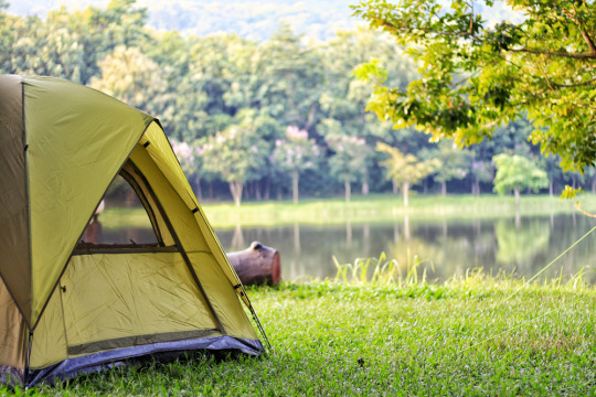
Camping is becoming ever more popular, and as a result many campsites can feel crowded with tourists and bland. Despite this, there are still a number of campsites in Wales that are hidden gems.
Aberafon, Llyn Peninsula
At the base of Gyrn Goch, the Aberafon campsite occupies a corner of the Llyn Peninsula. The site sits between mountains and the sea and has its own private beach. Aberafon is an ideal camping destination for surfers, and keen anglers such as Nishat Gupte.
Eastern Slade Farm, Swansea
Eastern Slade Farm is a peaceful location that offers outstanding views across the bays of Horton and Port Eynon. On-site facilities are limited; this is an intimate, family-run campsite. The area is home to a range of coastal walks, and Rhossili – the local tourist trap – can be easily avoided by those looking for a peaceful getaway.
Middle Ninfa, Monmouthshire
Middle Ninfa sits on the hills at the foot of the Blorenge, not far from the market town of Abergavenny. The campsite is eco-friendly, sustainable, and offers stunning views over Usk Vale and the Skirrid mountain. Campers can reach the site on foot up a steep path from Llanfoist. Campervans, cars and trailers are not permitted on the site.
Trellyn Woodland, Pembrokeshire
Trellyn is a tiny campsite, comprised of just five pitches across sixteen acres of woodland. The Trellyn campsite is so secluded that the Milky Way can be seen clearly at night. Stargazing is a popular activity, and the site has star charts available for campers to borrow. For campers who enjoy good food, the site has an outdoor pizza oven and field kitchen.
Ty Gwyn Farm, Ceredigion
Ty Gwyn offers sea views, a hidden beach, and an open field. The location may not offer much in the way of activities, but it encourages every visitor to relax in nature. The site itself is relatively unknown, and the owner has no intention of allowing it to become an overcrowded tourist trap in the future.
Outer Bounds, Ceredigion
As the name suggests, the Outer Bounds campsite is tucked away in the Ceredigion countryside. Pitches are spaced out for privacy, and the trees surrounding the site offer an interruption-free camping experience. This small site only offers the basics, and is therefore targeted at more experienced campers.
0 notes
Text
Hiking the Offa’s Dyke Path
June 8 – 14, 2021
After 11 days hiking in Iceland (essentially my quarantine period for traveling from the USA to the UK) I was on my way to the UK to visit my son, Luke, in London and the rest of my family in Sheffield. I would have a couple of spare weeks though to get some more hiking in and the Offa’s Dyke Path had always been on my bucket list. The path of 177 miles follows an ancient earthwork along the English-Welsh border from Chepstow to Prestatyn. Built in the 8th century by the Anglo Saxon King Offa of Mercia to keep the Welsh celts out, it started out as a high embankment with a ditch to the west – 1200 years on it varies in size from up to 25 feet high to no more than a few feet or less.
My plan had been to hike the whole path over 12 days, unless I could get to France for a few days to see my other son, Alex. In the event Macron did get his act together and I was allowed into France without quarantine, thus ending my hike at Buttington after seven days and 107 miles.
I navigated using a combination of old-school (way markers and Tony Gowers guide book) and high tech (AllTrails electronic maps), while having my luggage transported between accommodations (mainly Walklite) so I only needed to carry my day pack.
The typical landscape of gently rolling verdant hills up to 3000 feet altitude stretching to the horizon, much of it farmland crisscrossed with lines of hedgerow and darker patches of woodland, sat under an azure blue sky, where the floating cumulus clouds mirrored the abundant white flowering hawthorns below. A perfect example of what William Blake once described as ‘England’s green and pleasant land’ -- obviously applying to Wales also in this case.

And this was all interspersed with stretches of the dyke (akin to walking along to top of a disused and wooded railway embankment), ancient oak woodlands and patches of moorland and heathland.

On the way to Pandy from Monmouth I’d been looking forward to a thirst-quenching lunchtime pint at the Hogshead in Great Treadam, but found the pub locked up and dark. I was so grateful when Dale, the owner, saw me loitering outside in need of refreshment, and opened up just for me – the kind of personal touch I’d never had in NYC! We sat in the dark, chatting, while I downed a couple of beers, and he immediately locked up again when I left. All the pubs, restaurants and accommodation I visited along the path, in these small, out-of-the-way villages, were only just starting to open up after a very long pandemic hibernation period, and the owners all seemed kinda shell-shocked from the whole experience – it was as though they were now only just starting to take a peek down the road, not sure if there was another truck bearing down upon them.
Mary, the owner of Goytre View B&B near Pandy, was the most interesting person I met on the hike. An active 84 years young eccentric with a mild Welsh accent, she gave me lifts to a haunted pub and back, the Skirrid Inn, while honking at every house en-route, and almost veering into the hedge every time she turned to talk while speeding along those narrow country lanes – some even got two or three honks depending on who they were, and then she would laugh, explaining “they’ll be saying “here comes Mary”!!” She insisted I accompany her on a tour of her extensive collection of pot plants, watch her round up her chickens for the night and see the sun go down over the border in England. I’m so glad I met her.
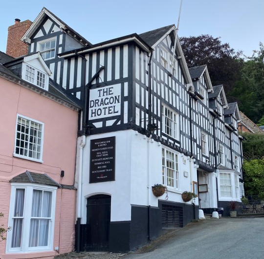
I mainly stayed in old, half-timbered pubs in small villages and towns -- Chepstow, Monmouth, Hay-on-Wye (second-hand bookshop capital of the UK), Kington and Knighton were all full of character and definitely worth a visit. The small village of Montgomery was probably my favorite though and I was thankful that I ended up there after the toughest leg of all from Knighton – 18 miles of many steep hills in a seemingly endless succession on a very hot and humid day, ending with a cold beer at the Dragon Hotel, a beautiful 17th century half-timbered building and my accommodation for the night.
Montgomery, which grew up around the 13th century castle guarding the River Severn crossing from the invading Welsh, had many interesting 16th and 17th century half-timbered buildings and later Georgian additions. There were many other 12th/13th century Norman castles on this hike, all built to keep the invading Welsh out – Chepstow, White Castle (between Monmouth and Pandy), Hay-on-Wye – and all a natural progression from Offa’s dyke.

It had been an enjoyable week hiking through England’s (and Wales’s) typical green and pleasant land, even though my trip to France had cut it short -- I vowed to hike the remaining 70 miles of the path from Buttington to Prestatyn as soon as I got the chance.
0 notes
Photo
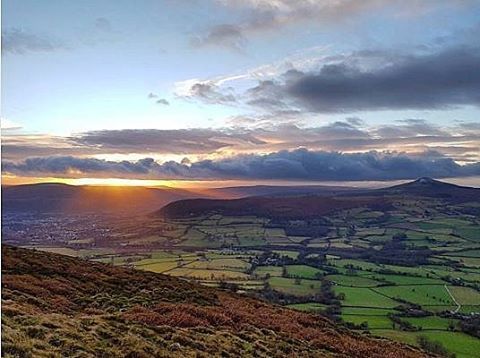
Skirrid Fawr #UnitedKingdom #Wales #landscape #mountain #outdoors #travel #traveling #visiting #instatravel #instago #nature #sky #scenic #tree #agriculture #fog #volcano #grass #daylight #panoramic #valley #hill #wood #cloud #monmouthcounty #skirrid #skirridfawr #daffodils (at Skirrid Fawr) https://www.instagram.com/p/BwJJRJbD9AA/?utm_source=ig_tumblr_share&igshid=peor8abjzmti
#unitedkingdom#wales#landscape#mountain#outdoors#travel#traveling#visiting#instatravel#instago#nature#sky#scenic#tree#agriculture#fog#volcano#grass#daylight#panoramic#valley#hill#wood#cloud#monmouthcounty#skirrid#skirridfawr#daffodils
0 notes
Photo
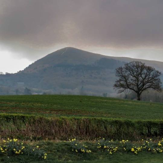
The sun sets, as shot from the Skirrid @ntbreconbeacons. The name ‘Skirrid’ is derived from the Welsh ‘Ysgyryd’, which means to shake or tremble - it’s easy to see where this name came from, with the massive landslide on the hill’s northern tip. The Skirrid is still prone to small mud flows and landslides today. Thanks to Laura Gibson for braving the elements – and quite a lot of mud – to get this image! #nationaltrust
15 notes
·
View notes
Last Seen Blogs

eruditetyro
I guess I'll have to do it while I'm here.

scarletimania99
Imania Margria

galacteas
kris


blonde-wreckage-blog2
blonde-wreckage